This an offset cache. The co-ordinates above
are not the final location
Following the route of
the newly-opened “Mourne Granite Trail” (4/5/05) which
runs from the old harbour to quarries on the eastern slopes of
Millstone Mountain. The final destination gives great views over
Newcastle and Dundrum
Bay.
Having found the cache (with a bit of luck!) you can
enjoy the rest of a circular walk via the Glen River and Donard
Forest. There is another cache
GCKNNN - Annesley's Ice House which can be found by taking this
route.
|
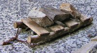
A “slipe” is a
roughly-fabricated wooden sled, usually horse
drawn.
Many types were used in
Mourne for transporting quarried or worked stone, and also to carry
seaweed (“wrack”) to the upland fields for use as a
fertiliser.
Two types can be seen on
the way to the cache.
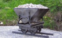
One of the cast-iron tilt
trucks (“bogies”) which ran on Mr. Lynn's
railway.
The bogies were often
overloaded, or worked out of gauge on the steep gradient. Accidents
were not uncommon.
|
This cache is a companion
to
GCN1Y9 Plugs and
Feathers, which also relates to the granite-working
industry in this area.
For many hundreds of years,
Mourne granite has been a highly sought-after building
material.
Granite is a hard igneous rock, of relatively low density and
usually containing felspars, quartz and other decorative minerals.
It is capable of being worked and polished to a high finish.
Several distinct types of granite are found in the high Mournes,
and two of them can be observed near the cache location. In
geological terms these are the most recent rocks, and were formed
by volcanic intrusion around 45 million years ago.
In 1824, a rope-drawn (funicular) narrow-gauge railway was
installed to carry stone from the quarry on Thomas's Mountain to
the quay at King Street. The route to the cache site follows the
line of this railway. Though it has since been dismantled, some of
the original drilled base slabs now form part of the path, or can
be seen beside it.
The upper part of the cache route leads through land used for
grazing livestock. Dogs should be kept on a lead at all
times.
      |
|
Although this
route starts in town, the path is steep and, on the upper sections,
can be wet and muddy in winter. Please ensure that you have
adequate footwear and take the normal precautions as for any upland
hike. Take care near the final cache
location, as the rock shards underfoot are loose, and slippery when
wet.
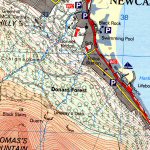
Directions:
From Newcastle town centre: Follow the one-way system to the
traffic lights at Bryansford Road. Bear left (South Promenade) and
continue 1 km (0.7 mi). Find the entrance to the harbour/lifeboat
station on left, and park here. (N54º 11.836 W05º
53.131)
Leave the car park, cross the
A2 (with care) and up a short footway leading to King Street. The
start of the Granite Way path is at N54º 11.813 W05º
53.250
|
Click
below for a map of the area (Multimap.com)
|
The Cache: The co-ordinates on this page will take you to
an interesting structure which was installed as part of the
“Granite Way” project. Using the clue below, work out
the final co-ordinates to find the cache, which is about 240m away.
Because of the particular local terrain, it is not easy to obtain a
good GPS fix, and you may need to spend some time on this.
|
|
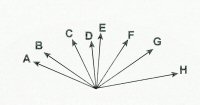
The cache coordinates are... N54
11.JKL, W005 53.XYZ in miles
of...
J=F/B K=(H-E)/G L=F/G
X=C/D Y=E-G Z=A+A
|
These co-ordinates were surveyed using three GPS receivers and
WAAS/EGNOS differential corrections. They are accurate to within
two metres. The cache itself is a tab-lock box 20x15x10 cm, wrapped
in black material and hidden at ground level. It contains a
selection of swap items, including a set of unregistered Travel Bug
tags for the first finder.
When replacing the cache, please make sure
that it is not visible from above.
Tks.
