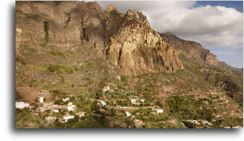
Risco Blanco, an igneous intrusion
Geology
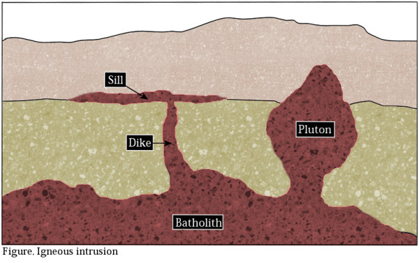
An intrusion is simply liquid rock (magma) that is slowly pushed upwards from deep within the earth. It forces its way through cracks and fissures in the pre-existing rock and eventually reaches the earth's surface. These fissures can be parallell to the existing strata (sills) or cutting through them (dikes) and can clearly be seen after erosion has worn away the surrounding softer rock. Depending on several factors the magma either solidifies before it reaches the surface due to a decline in the magma suppply (an intrusion) or continues to flow until reaching the surface as in a volcanic eruption (an extrusion). Huge dome shaped bodies of rock can be created underground this way. These intrusions can become exposed after millions of years due to erosion or gravitational collapse of the surrounding rock as is the matter with the Risco Blanco. Spectacular pillars, towers and domes can be created this way. The creation of the intrusion itself can also take millions of years, making it a very slow geological process. When the magma solidifies the different parts of it slowly crystallizes into minerals. A slow cooling generally means larger crystals. Volcanic rock, crystallizing on the surface of the earth has been cooled quickly and therefore only contains microscopic crystals. An example of this is volcanic ash where the crystals are mere dust particles. Larger crystals are therefore bound to be found deeper in the surface of the earth and generally don't come into view until after several millions of years. One of the worlds largest known crystals, over 10 meters across, has been formed in this way. Many mountain ranges, generally made from granite or related rock, are formed mostly by intrusive rock. The size of intrusions vary widely, so called batholiths are mountain range sized (over 100 square kilometres) and some vein-like fracture fillings are only a few centimetres thick. Plutons often rise in groups so a batholith can be composed of several merged plutons. A striking example of an originally globular pluton is the Half Dome mountain in Yosemite National Park in California.
The Risco Blanco igneous intrusion is situated in the northern wall of the Tirajana caldera (depression) at the centre of Gran Canaria. It is only one of a significant number of these formations on the island but it is by far the largest of them all. With a height of 400 m the white cliff is visible for miles around. The intrusion is dated to be 3.8 million years old and was originally covered by the older Roque Nublo lavas. During the last 2.5 million years the Tirajana caldera was created by gravitational collapse and erosion and the Risco Blanco intrusion therefore exposed.
The coordinates lead to a bend in the road with a good, close look up the cliffside.
To log your visit you have to email me the answers to these questions:
1. What is the approximate base diameter of the visible part of Risco Blanco?
2. Near the coordinates (in the uphill embankment just after the bend towards the village Risco Blanco) there is a layer of rock, lighter in colour than the surrounding layers. What is the colour of this layer?
3. With what would you compare this layer's hardness: A. Chalk (very soft), B. Sandstone (medium soft) or C. Flint (very hard)?
4. A photo of yourself and the cliff would be much appreciated but is not necessary to complete the logging.
Send your answers to the cache owner and wait for an OK before you log your visit, please.
Good luck!
Tareas para registrar el caché: envíame un correo-e con las respuestas a estas preguntas:
1. ¿Cuánto aproximadamente es el diámetro de la base de la parte visible del Risco Blanco?
2. Cerca de las coordenadas del caché (en la parte arriba de la carretera, después de una curva yendo hacia el pueblo de Risco Blanco) encontrarás un estrato de roca de color más claro que el que está alrededor. ¿De qué color es este estrato?
3. ¿Con qué compararías la dureza del estrato: A. creta (muy blando), B. arenisca (medianamnete blando), C. sílex (muy duro)?
4. Te agradecería mucho una foto de ti en frente del risco (no obligatorio). Por favor envía las respuestas al propietario del caché y espera una confirmación antes de registrar tu visita. [Traducción al español: Dulsineja]
1. Wie groß ist der ungefähre Durchmesser des sichtbaren Teils des Risco Blanco?
2. In der Nähe der Koordinaten (auf der dem Berg zugewandten Seite; unmittelbar hinter der Kurve in Richtung des Dorfes Risco Blanco) ist ein Felsabschnitt zu sehen, der heller als der restliche Fels ist. Welche Farbe hat dieser Felsabschnitt?
3. Womit würdest Du die Härte dieses Felsabschnitts vergleichen: A. Kalk (sehr weich), B. Sandstein (mittelhart) oder C. Feuerstein (sehr hart)?
4. Ein Bild von Dir und dem Felsen wäre nett, ist aber keine Logbedingung.
Sende Deine Antworten an den Cache Owner und warte auf die Logfreigabe.
 The most exciting way to learn about the Earth and its processes is to get into the outdoors and experience it first-hand. Visiting an Earthcache is a great outdoor activity the whole family can enjoy. An Earthcache is a special place that people can visit to learn about a unique geoscience feature or aspect of our Earth. Earthcaches include a set of educational notes and the details about where to find the location (latitude and longitude). Visitors to Earthcaches can see how our planet has been shaped by geological processes, how we manage the resources and how scientists gather evidence to learn about the Earth. To find out more click HERE.