
Artle Beck separates the two modern-day villages of Caton and Brookhouse. Confusingly, the name Caton originally referred to the settlement now known as Brookhouse. (The change occurred in the nineteenth century as a part of a reorganisation of addresses by the General Post Office and Lancashire County, when the older name was transferred to the growing development of dwellings and mills originally known as Town End.) Artle Beck was central to the development of the new Caton; its rapidly flowing waters providing the power for numerous mills.
The earliest mills hereabouts probably date from Roman times; a Roman millstone was discovered in the beck in 1803 and is now on display in Lancaster City Museum. In less ancient times, after providing power for Crossgill Mill (higher up the valley in Little Dale) and the Gresgarth Corn Mill, Artle Beck fed a mill race which took water from the beck to supply, in turn, Forge, Rumble Row, Willow and Low Mills before discharging into the River Lune. Another, Ball Lane Mill, was located further downstream on Artle Beck, beyond the old railway line.
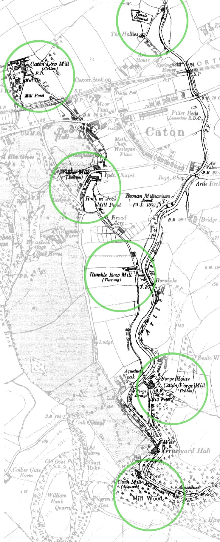
Sites of Caton's former mills, Artle Beck and its mill race (1919 survey, courtesy of The Ordnance Survey)
Ball Lane Mill burned down in 1846; Rumble Row and Forge Mills were closed down in the 1930s; Willow and Low Mills continued to operate until the 1970s, although by then, of course, they had turned to more modern sources of power. During their two centuries of working, these mills manufactured a variety of textiles — silk, flax, cotton — and in the case of Forge and Willow Mills, bobbins for the textile industry (and the other mills).
With the exception of Rumble Row and Ball Lane Mills, many of the former mill buildings still remain, now converted into residential properties and commercial office units. The old millponds above Low Mill now house a fishery. Rumble Row Mill was demolished to make way for a post-war housing development; the former site of Ball Lane Mill is now occupied by the Lunesdale Tennis Club.
The old mill race still remains more or less intact and can traced for some of its length. Originating at a weir across the beck on the private Gresgarth Hall estate, it makes its way through estate woodland on the east side of the beck to the site of Forge Mill. The first accessible glimpse to be had of it now is below Forge Mill, where it crosses Artle Beck on an ancient iron aqueduct, after which it rapidly disappears again beneath the newer development at the head of Broadacre. Shortly after Broadacre Cottages, the race emerges once more from under a road bridge, to run along the roadside, first of Broadacre and then of Kingfisher Court, heading for Willow Mill, through which it is now piped. Beyond Willow Mill, it runs through private properties, to reappear briefly at The Croft, passing the Fish Stones, before entering another culvert taking it under the main road on its way to the mill ponds above Low Mill. From these ponds, the old race turns west to enter the River Lune at the Crook.
This cache is a simple two-stage multi. You will find the coordinates of the final stage hidden at the published coordinates. It is a short walk away.
There is no need to disturb anything to locate either stage of the cache; please rehide carefully.
ACCESS NOTE: If approaching this cache from Forge Mill, please note that there is no vehicular access beyond the Forge Mill residential complex (and no public parking there to speak of). The footpath does continue along the drive to the old equitation centre as far as a stile into the field on the right (at Waypoint STILE) with the right of way crossing the field to a kissing gate at a bearing of 20°. Don't go through the kissing gate, however; instead, bear left to cross the field again, to a stile in the fence beyond the cow barn.

Congratulations to highbarn2 for a very fast FTF - within 2 hours of publication!