Hemr Rocks

(ENG)
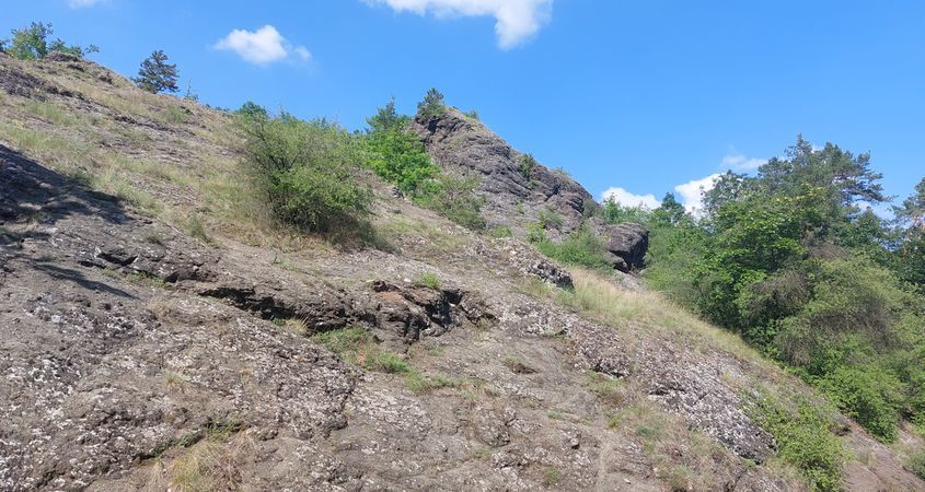
The Hemr Rocks are composed of older volcanic minerals, which have penetrated to the bottom of the sea in the course of Silurian Period, some 423 million years ago. These minerals made basis for a submarine volcano; the top of this volcano is probable to have reached the level of the sea. The origin of the volcano was preceded by origin of a supply fissure which was several metres wide and approximately five kilometres long. Through this fissure, magma was penetrating to the bottom of the sea and it was cooled very rapidly by means of contact with sea water. This activity was accompanied by eruptions connected with belching of volcano ashes of pieces of solidified magma as well as of minerals from the whole fissure; this process was always terminated by magma exudation.
The Hemr Rocks constitute just the southern slope of the volcano. The length of the volcano was about 5,5 kilometres, its width is approximately 2 kilometres and its height amounted to 200 to 300 metres above the sea bottom. The mass of volcanic eructated mass has been estimated, in the course of measuring, to one cubic kilometre. In the course of its activity, the volcano has lifted the sea bottom and enabled development of sea fauna.
The rocks are only the southern slope of the volcano, on which there are very unfavorable conditions for the growth of vegetation on its southern side. Rocks are not able to hold a large amount of water, temperatures have a relatively large range during the day and night. These conditions are extreme for vegetation and can be compared to rocky steppe and semi-desert. Plants take root mainly in rock crevices and on moving debris. On the surface, which is mostly bare, there are tufts of grasses and rich carpets of motherwort, sedge-flowering gray sedges (Helianthemum canum), dry-loving mountain sedges (Alyssum montanum). Stonecrops (Sedum album and Sedum sexangulare) can also be found on the rocks. Thanks to the diabase base, the highly endangered garlic (Allium strictum) is also found here, which is classified as a glacial relic. Another interesting plant is the Czech meadowsweet (Pulsatilla pratensis subsp. bohemica). Blooming Hemra rocks can only be seen in the spring months, in autumn and winter there are more lichens and mosses on the rocks. On the northern side, where the temperature differences are not extreme, there is relatively rich afforestation, which was also made by man, the afforestation reaches as far as the Jinonické stream.Because of the fact that the slope of Hemr rocks is just thinly covered by vegetation, the dark colour of volcano products is thus visible. The North Slope above the valley of the Jinonice brook is covered, thanks to more favourable climatic conditions, with much greater quantity of plants. Out planting of wood species has been performed here.
To log this cache you have to:
In the log, insert a photo from the coordinates of the earthcache or its stop, at which you are or it is clearly recognizable which hunter it is, i.e. a photo with GPS and a nickname, a trackable object that accompanies you and a nickname.
Answer a few questions via email via profile:
- In what period were the Hemra Rocks formed? Listing
- At the starting coordinates, opposite the oak, there is a rockery, when viewed looking at her there, there is basalt colored in two shades of colors, what? A visible rift separates them. How does such a crack widen and what aids erosion in place? An example is right on the given rock.
- At the second stop, there is lava pillows under the rocks themselves. How many pillows are there to see?
- What kinds of plants live here? It depends only on you whether you use the listing or rely on your observation.
Hemr rocks is a Nature reserve where it is forbidden to ride a bicycle and tear anything, walking is only allowed on footpaths or paths. Respect it.
Hemrovy skály
(CZE)
Hemrovy skály jsou složeny ze starších vulkanických hornin, které v Siluru před zhruba 423 miliony let vyvřely na mořské dno a vznikla z nich podmořská sopka, vrchol sopky pravděpodobně dosahoval až k mořské hladině. Sopku předcházel vznik přívodní pukliny široké několik metrů a dlouhé přibližně pět kilometrů. Touto puklinou na mořské dno proudila basaltová láva, která se rychle ochlazovala při styku s mořskou vodou. Tuto činnost provázely erupce doprovázené vyvrhováním sopečného popela, kusů již ztuhlé lávy a hornin z celé pukliny, toto vždy zakončil výron lávy.
Hemrovy skály tvoří pouze jižní svah sopky. Délka sopky byla okolo 5,5 kilometru, šířka přibližně 2 kilometry, výška činila okolo 200 až 300 metru nad mořským dnem. Hmota vulkanických vyvrženin byla během měření odhadnuta na 1 kilometr krychlový. Během své činnosti sopka zvedla mořské dno a umožnila rozvoj mořské fauny.
Skály které jsou pouze jižním svahem sopky, na kterém jsou na jeho jižní straně velice nepříznivé podmínky pro růst vegetace. Skály nejsou schopny udržet větší množství vody, teploty mají během dne a noci poměrně velký rozsah. Tyto podmínky jsou pro rostlinstvo extrémní a dají se přirovnat ke skalní stepi a polopoušti. Rostliny zakořeňují převážně ve skalních puklinách a na pohyblivé suti. Na povrchu, který je vesměs holý se nacházejí trsy trav a bohaté koberce mateřídoušky, žlutě kvetoucí Devaterníky šedé (Helianthemum canum), suchomilné tařice horské (Alyssum montanum). Na skalách se též dají nalézt rozchodníky (Sedum album a Sedum sexangulare). Díky diabasovému podkladu se zde vyskytuje i silně ohrožený česnek tuhý (Allium strictum), který je přiřazován ke glaciálním reliktům. Další ze zajímavých rostlin je koniklec luční český (Pulsatilla pratensis subsp. bohemica). Rozkvetlé Hemrovy skály je možné spatřit pouze v jarních měsících, na podzim a v zimě jsou na skalách spíše lišejníky a mechy. Na severní straně kde nejsou rozdíly teplot extrémní se nachází poměrně bohaté zalesnění, které bylo uskutečněno i člověkem, zalesnění sahá až k Jinonickému potoku.
Pro uznání logu musíte splnit:
Do logu vložte fotografii ze souřadnic earthcache nebo její zastávky, na které jste Vy nebo jasně rozpoznatelné o jakého lovce jde tj, foto s gps a nickem, trackovatelným předmětem co Vás doprovází a nickem.
Odpovězte na pár otázek emailem pres profil:
- V jakém období Hemrovy skály vznikaly? Listing
- Na výchozích souřadnicích naproti dubu se nachází skalka, při pohledu na ní se tam nachází basalt zbarvený dvěma odstíny barev, jakými? Rozděluje je patrná trhlina. Jak se taková trhlina rozšiřuje a co napomáhá erozi v místě? Příklad je přímo na dané skalce.
- Na druhé zastávce se nachází pod samotnými skalami polštářová láva. Kolik polštářů tam je k vidění?
- Jaké druhy rostlin zde žijí? Záleží jen na vás zda využijete listing nebo se spolehnete na své pozorování.
Hemrovy skály jsou Přírodní rezervace kde platí Zákaz jízdy na kole a trhání čehokoliv, chůze je povolena pouze po pěšinách nebo cestách. Respektujte to.
Source and other information: http://botany.cz/cs/hemrovy-skaly