MA Ghost Town Multi-Cache
-
Difficulty:
-

-
Terrain:
-

Size:  (small)
Please note Use of geocaching.com services is subject to the terms and conditions
in our disclaimer.
Preface
The original cache was a multi with a container near the parking area that contained laminated pages of historical images of the center of Dana. The final cache was placed half-way to Graves Landing. The containers were traditional ammo cans hidden in stone walls.
V2 of the cache resulted in the containers being moved from the walls to inconspicuous ground locations (as the dcr requested we remove cache containers from the walls).
V3 of the cache is the latest hide. As caching is no longer permitted in the Quabbin the cache is now a small container that will hopefully keep this cache alive. While it could be considered a park and grab the hope is you'll still take the time to visit the center of Dana. And no need for the laminated cards as you'll now find posts with pictures showing what some of the buildings and area looked like before the town was dissolved and dismantled.
Welcome to the MA Ghost Town Cache!
After finding this cache you can explore some of the wilderness areas of the Quabbin Reservation and the old town of Dana - now a ghost town!
Background
 In the early 1900's it was determined that eastern Massachusetts was going to need a long term reliable source of water. Legislation was passed that called for the building of two large dams that would block the Swift River and flood most of the former towns of Dana, Greenwich, Enfield and Prescott. This cache is dedicated to all those who sacrificed their homes and way of life.
Dana MA was one of the four towns that was lost in the creation of the Quabbin Reservoir. Unlike the other towns of the Quabbin, the center of Dana was never submerged and today remains a ghost town. The Town of Dana was incorporated on 18 February 1801 and was dissolved on 28 April 1938. Although the buildings have long since been removed the foundations, roads and even sidewalks remain for you to explore.
Access
Dana (and the cache) is located in the Quabbin Reservoir watershed system, which is maintained by the Mass Department of Conservation and Recreation (formerly the Metropolitan District Commission or MDC). Please abide by all rules and regulations which are posted at access gates. Information is also available at the visitor's center (see info below).
Access is allowed from one hour before sunrise to one hour after sunset. Bicycling is allowed on the paved roads (including those around this cache). Animals are NOT allowed. Temporary restrooms are usually setup near the parking area, the center of Dana as well as near the reservoir west of the center (see Quabbin map). (NOTE: due to COVID-19 the restrooms may not be available.) During appropriate seasons bug spray and tick precautions are advised.
To visit Dana proceed to the Gate 40 parking area (N 42 26.457 W 72 12.570) on Hardwick Road (Route 32A) in Petersham MA. This area is also known as Nichewaug; many maps may still indicate this name. (Quabbin gates are sequentially numbered in a clockwise location around the reservation).
The Cache
The cache can be easily found from the Gate 40 parking area. If you do take the hike to Dana we'd love to see photos with your log.
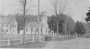
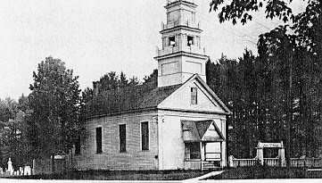 Dana Common
As you venture into the center of Dana you will find on the north side of the common Dana's town hall and school - today only the foundations and memories remain. In the field behind the school's foundation was the town cemetery. Now all that remains are the granite posts that once lined its borders. (The people interred in the four towns' cemeteries were moved to other facilities; many ended up at Quabbin Park Cemetery located at N 42 16.750 W 72 18.333)
At the west end of the common was the Eagle Hotel. Opened in the early 1800's this facility boasted 15 rooms - quite something for a small rural town who never had more than 900 inhabitants.
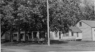 On the south side of the common, along a road that leads out into a field and eventually the reservoir, is the foundation of Edgar Vaughn's home. It is unique in the fact that it is constructed of small stones most likely from nearby streams. See if you can find the foundation shown in the lower right hand corner of the picture!
To appreciate what it may have been like please see the photos and maps that can be found in the first note logged for this cache (you may need to click on the View them all on one page link and scroll all the way to the bottom to see that log). The cache description photos can be found there as well.
Duration
A round trip to the center of Dana is approximately 4 miles and is fairly level on an old paved road. If you want to continue on to Graves Landing the round trip is 8 miles; you should also expect some significant elevation changes on that road. Dana common is suitable for year-round visitation and family friendly - its a beautiful place. Of course, the best time may be in late fall when foliage is gone and more of what has been left behind is evident. And speaking of left behind, please remember to cache in - trash out!
Additional Information
Quabbin Visitor's Center
285 Ware Road
PO Box 628
Belchertown MA 01007
413.323.7221
9:00 AM to 4:30 PM daily
emergencies / violations: Mass State Police 413.323.7561 (cell: *MSP or 911)
rangers: 413.323.0191
Mass DCR East Quabbin Reservation Bicycle Access map: http://www.mass.gov/dcr/waterSupply/watershed/documents/eastquabbike.pdf
Friends of Quabbin: http://www.friendsofquabbin.org
WBGY Under Quabbin documentary: http://www.wgby.org/localprograms/pages/quabbi n.html
Good Luck!
Additional Hints
(Decrypt)
TEP T40