
 Check the tides before trying this one. If you get the timing wrong you are going to get wet.
The Ovens are a series of natural sea caves that are the result of the horizontal layering of the rock, vertical fractures, and a series of faults.
The Ovens are carved out of the Bar Harbor Formation. This formation is generally made up of thin layers of siltstone and sandstone that were deposited in a shallow ocean in the late Silurian to Mid Devonian (~410 -380 million years ago). This layering can more easily be seen east of the Ovens especially near the pier in Bar Harbor. However at the Ovens, the layering is very difficult to see and is described as more massive.
Layering can be recognized in the cliff side based on how the rock erodes. Near the base of the cliff, there is a layer of rock that is more easily eroded than the rock further up the cliff. It is in this more easily eroded layer that the ovens form.
The second feature that helps form the Ovens are the vertical fractures in the rock. Fractures are natural cracks in the rock that form from change in pressure or temperature (kind of like ice cracking when you put it in water). These can be seen on the rock outcrops that poke out through the rocky beach. These fractures create weak points in the rock where erosion occurs more rapidly.
The final feature is the slightly inclined faults that can be traced all the way up the cliff. There appears to be little movement along the faults, but there has been enough to decrease the strength of the lower layer that already was more easily eroded.
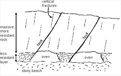 These three features combine to create areas in the rock that are much more easily eroded creating the cave features called the ovens.
Logging requirements:
Send me an EMAIL, (not a message) via the user profile link above with the following information:
- The text "GCZ5JA The Ovens–2 if by land, 5 if by sea" on the first line
- The number of people in your group and if anyone is logging separately, their login name(s)..
- Estimate the distance between two of the faults.
- What are the three features of the rock formation that contributed to the development of the ovens?
- Within 1 foot of the ovens along the fault, describe the condition of the rock.
- Optional: Post a photo of you with your GPS while inside the largest oven of the floors, wall or ceiling
Be sure to check the box to include your email address with your answers so that I can send you the OK to log. Any logs posted before I receive your email and qualify your find or logs containing spoilers will be deleted without prior notice.
The following sources were used to generate this cache:
- Maine Geological Survey, Department of Conservation, The Ovens, Bar Harbor, http://www.maine.gov/doc/nrimc/mgs/explore/bedrock/sites/jul03.htm, last updated 10/6/2005
- Gilman, Richard A., Carleton A. Chapman, Thomas V. Lowell, Harold W. Borns, Jr., The geology of Mount Desert Island A Visitor’s Guide to the Geology of Acadia National Park, Maine Geological Survey Department of Conservation, 1988