Harts Pass is one of the most scenic spots in the Methow Valley.
Visitors can continue another 1-1/2 miles to a spectacular view
from the highest point to which you can drive in Washington State.
Vehicles can drive to within 1/4 mile of Slate Peak and hikers can
hoof it to the 7488 foot lookout atop the peak. Slate Peak provides
visitors with an unparalleled view of the North Cascades, including
Mt. Baker to the west. At Slate Peak Lookout, Geocachers will enjoy
finding
DEW Line cache by Barnabirdy(s) at
the lookout tower.
The Hart's Pass road is rock-surfaced, passable by passenger
cars. However, due to the steep, narrow roadway, and lack of large
turnouts, the road is closed to all trailers.
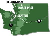
The Hart's Pass road begins at Mazama, 17 miles north of
Winthrop, on a paved country road, turning to dirt at Lost River
bridge. Travel time from Mazama to Hart's Pass is about 45 minutes
on busy weekends. Slate Peak is another 15 minutes from Hart's
Pass.
Points of interest on the Hart's Pass road:
- Robinson. The frontier town of Robinson, near the mouth of
Robinson Creek, began its life in 1887 as "Camp Troublesome." No
trace of the town is left, but there is a Forest Service campground
nearby.
- Viewpoint. The upper Methow Valley is a classic glacier-carved
valley with steep sides and a flat bottom. The bottom is filled
with glacial rubble hundreds of feet thick. Ice receded from the
area some 14,000 years ago, leaving a few small glaciers on high
peaks.
- Last Chance Point. Gateway to the Robinson Creek drainage. A
huge rockslide can be seen stretching from the craggy summit to the
valley bottom.
- Deadhorse Point. Local legend says the place was named when
horses in a pack string panicked and ran down the narrow trail.
More trail-wise mules tried to stop, but the horses proved stronger
and pulled the whole string over the edge to its death.
- Salt lick. Animals often can be seen below the road above
Deadhorse Point. It's not a good idea to stop on the narrow
road.
- Pasayten Driveway. A livestock trail along which sheep were
herded from the Columbia Basin to high mountain pastures.
- Tilted strata. Near Hart's Pass, look south to see tilted
layers of rock exposed in the steep mountainsides. It was laid down
at the bottom of an ancient sea.
- Guard station. A lookout point during World War II and the
Cold War.
- Road to Barron and Chancellor. The road splits at Hart's Pass,
with one fork (to the left) diving into Slate Creek and the
remnants of two old mining towns. Barron is on private land behind
a locked gate. The road ends shortly beyond Barron at a washed-out
bridge three or four miles before the ghost town of Chancellor.
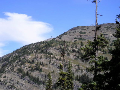
- Slate Peak. A small parking lot perches on the divide just
below Slate Peak, elevation 7,488. It's a short, somewhat steep
hike on a graveled road to the summit, which boasts a fire lookout
and panoramic view of the North Cascades. Interpretive signs at
Slate Peak Lookout identify the major peaks and mountains in the
United States and Canada, which include:
Mt. Baker (elevation 10,778 ft), Jack Mountain (elevation 9066
ft), Gardner Mountain (elevation 8897 feet - once the highest
lookout in the state of Washington located there), Silver Star
Mountain (elevation 8876 ft), The Needles (elevation 7925 ft),
Tower Mountain (elevation 8444 ft), Golden Horn Mountain (elevation
8366 ft. - made of granite found only in this area), Azurite peak
(elevation 8420 feet - partly made of azurite, a blue green copper
ore), Mount Lago (elevation 8745 ft), Mount Carru (elevation 8595
ft), and Devil's Peak (elevation 8081 ft - one of the most rugged
in the Pasayten Wilderness).
There are no restroom facilities at the summit or parking lot,
but there are farther down the road. Snow stays on the road well
into late spring and begins falling again in early fall.
Hart's Pass provides access to a number of trails, including the
Pacific Crest
Trail.
Hope you enjoy the hike to the cache. Here is a picture taken
from the cache looking toward Slate Peak Lookout, home of
DEW Line cache.