A
Earthcache
No texto abaixo, assim como no local das coordenadas, onde irá encontrar um painel informativo, poderá obter as informações necessárias para responder às seguintes questões. Estas devem ser respondidas para o meu
email de modo a poder fazer o registo como encontrada. Se tal não for feito o registo será apagado sem qualquer tipo de aviso. Não necessita de esperar pela minha autorização para efectuar o registo. Se existir algum problema será contactado(a) de modo a resolvê-lo.
- A que períodos é actualmente atribuído a origem e evolução das ilhas barreira da Ria Formosa?
- De que zonas geológicas e sensíveis se fala no painel?
- Que animal está na fotografia (não no símbolo do Parque Natural) do lado esquerdo do painel?

The Earthcache
In the text below, as well in the place pointed by the coordinates, where exists an informative panel, one can find the necessary information to answer the following questions. These should be sent to my email in order to make a found log. Failing to do this will result in the deletion of your log without notice. You don't need to wait for permission to log. If there is a problem you will be contacted to resolve it.
- To what periods are currently attributed the origin and evolution of the barrier islands in Ria Formosa?
- What geological and sensitive zones are referred in the panel?
- What animal is in the photo (not the Natural Park symbol) on the left side of the panel?

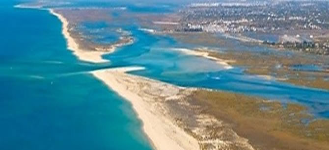
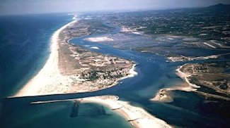
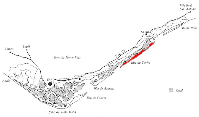
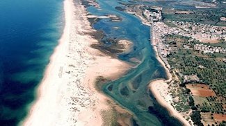
Ilha de Tavira
O sistema barreira da Ria Formosa é constituído por uma série de penínsulas e ilhas que delimitam um ambiente lagunar interior. A Ilha de Tavira é a maior do sistema. Tem forma alongada segundo o eixo SW-NE, comprimento aproximado de 11 quilómetros e largura máxima de cerca de 800 metros na parte central. Estreita progressivamente para SW, existindo indícios, nesta extremidade, de forte erosão. Na maré vazia são nítidos, nesta ponta, afloramentos de materiais silto-argilosos com elevado conteúdo vegetal típico de ambiente de sapal, a que se sobrepõem as areias que constituem a ilha. Testemunham, por um lado, a progressão da ilha sobre a laguna e, por outro, a erosão que esta ponta tem vindo a sofrer. A extremidade oriental da ilha está estabilizada artificialmente pelos molhes da Barra de Tavira, o que levou à acumulação de sedimentos, a ocidente da barra.
É actualmente aceite que a origem e evolução das ilhas barreira, na Ria Formosa, está relacionada com variações relativas do nível do mar ocorridas, principalmente, durante os períodos glaciários e interglaciares. O máximo glaciar ocorreu há 18.000 anos e as temperaturas da água chegaram a atingir valores inferiores a 4
o C. Globalmente o nível médio das águas do mar desceu, levando os rios a rejuvenescerem e a aprofundarem os seus vales. A erosão fluvio-glaciar, a fusão estival de gelos e a precipitação primaveril combinaram-se para conferir caudal elevado a estes rios, que por isso tiveram energia suficiente para transportar grandes cargas sedimentares de calhaus, que foram depositados intercalados com areias e argilas. Há cerca de 10.000 anos a desglaciação acentuou-se significativamente e com ela começou também a subida do nível do mar. Isto provocou o início da rectificação da costa com erosão de cabos e acumulação de sedimentos nas reentrâncias, bem como o início da formação de barras submersas que evoluíram para ilhas barreira de um sistema lagunar - a Ria Formosa, com extensos campos de dunas.
O sistema de ilhas-barreira da Ria Formosa apresenta algumas características peculiares, tais como a inexistência de um grande rio, as condições de amplitude de maré a que está sujeito e a disposição geral do sistema, em forma de triângulo escaleno com vértice virado a Sul. As marés têm regime de meso-marés, com uma amplitude máxima de aproximadamente 3,5 metros nas marés vivas, encontrando-se no limite máximo para a formação de ilhas-barreira.
Tavira Island
The Ria Formosa’s barrier system is a group of peninsulas and islands that delimit an interior lagoon environment. The Tavira island is the biggest of all the system. Has an elongated shape in the SW-NE direction, with approximately 11 kilometres of length and a maximum width of 800 metres in the middle. It narrows progressively to SW, where is visible some signs of strong erosion. In the low tide it is clear, in this edge, some outcrops of clay silt materials with high levels of vegetal content characteristic of saltmarsh systems, overlapped by the sands that form the island. This show, on the one hand, the advance of the island over the lagoon and, on the other hand, the erosion that this edge has been through. The east end of the island is artificially stabilised with the Tavira sea mouth breakwaters, which led to the accumulation of sediments, at west of the sea mouth.
Nowadays is accepted that the origin and evolution of the barrier islands, in Ria Formosa, is related with the sea level variations occurred, mainly, during the glacial and interglacial periods. The glacial maximum happened 18,000 years ago and the water temperature reached values below 4
o C. Globally the mean sea level dropped, which made the rivers gain new life and deepen its valleys. The erosion fluvio-glacial, the ice summer melting and the spring rain combined gave a heavy current to these rivers, which because of that had enough energy to carry a big amount of rock sedimentary loads that were interspersed deposited with sand and clay. About 10,000 years ago, the deglaciation aggravated significantly and with it started also the raise of the sea level. This cause the beginning of the coast adaptation with the erosion of capes and sediment accumulation on the cavities, as well as the beginning of the underwater sea mouth formation that evaluated to barrier islands of a lagoon system - Ria Formosa, with extensive dune fields.
The barrier island system of Ria Formosa has some peculiar characteristics, such as the fact that there is not a large river, the tidal range conditions that its exposed to and the system general line-up, in the shape of a scalene triangle with the vertex pointing south. The tides have a meso-tidal condition, with maximum amplitude of approximately 3.5 metres during the spring tides, being this the extreme limit for the formation of barrier-islands.