The top of the bluff has Platteville dolomite with a thin layer of till and several erratics. The till and erratics indicates that this bluff was glaciated.
The Baraboo Range, located in south-central Wisconsin, is an oval ring of hills approximately 30 miles long and 10 miles wide. The range, which formed over 1.6 billion years ago is one of the oldest rock out crops in North America. The Devil’s Lake gorge is one of several gaps that cut the Baraboo range. It is generally believed that the Wisconsin River once flowed through this gorge. 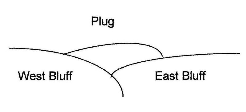
Approximately 15,000 years ago, a glacier flowed over the eastern half of the Baraboo range. The driftless (unglaciated) area lies to the west. The glacier wrapped around the eastern bluffs and advanced into both the north and south end of the gorge. When the glacier melted back, it deposited a terminal moraine at the two open ends of the gorge. These moraines acted as plugs to create the Devil’s Lake basin in between. The northern plug blocked the flow of the Wisconsin River and caused it to be re-routed from a southerly to an easterly direction.
The glacier acts like a conveyor belt to carry debris. A moraine is an accumulation of the debris (ranging from silt-sized grains to large boulders) deposited at the end of the glacier. The longer the end of a glacier stays in one place, the more debris will accumulate. The moraine at the southern end of the Devil’s Lake basin is approximately 130 feet thick. This moraine can be seen from the hill you will be standing on at the coordinates for this cache by looking north-westerly (300-315°). It is 5-6 miles away.
>p>
 IATCC is the cache designation to highlight a series of EarthCaches along the Ice Age National Scenic Trail grouped into a special category called "ColdCache."
The Ice Age Trail is one of eleven National Scenic Trails designated by the National Park Service. This unique trail is entirely within the state of Wisconsin and follows along the terminal moraine of the most recent glacier which retreated about 10,000 years ago.
This project is supported by the Ice Age Trail Alliance (IATA). The goal is to bring more visitors to the trail and promote public awareness, appreciation, and understanding of Wisconsin’s glacial landscape.
The IATA has created an awards program to encourage visits to the trail and ColdCache sites. This awards program is separate from, and in addition to, any other Geo- or EarthCache awards program.
A current list of approved ColdCache sites can be found on the “IATCC Bookmark List”. More information on the Ice Age Trail Atlas, the Companion Guide, the ColdCache Project and Awards Program can be found on the “ColdCache Webpage”
The Geocache Notification Form has been submitted to Steven Schmelzer of the Wisconsin DNR. Geocaches placed on Wisconsin Department of Natural Resource managed lands require permission by means of a notification form. Please print out a paper copy of the notification form, fill in all required information, then submit it to the land manager. The DNR Notification form and land manager information can be obtained at: www.wi-geocaching.com/hiding
Resources:
The Baraboo Ranges and Devil’s Lake Gorge – A Geological Tour; by Keith Montgomery, Dept. of Geography-Geology, University of Wisconsin, Marathon County
Wiki Books: Geological Features of Wisconsin – Devil’s Lake
Wikipedia
Wisconsin DNR
Look northwesterly 300-315° with binoculars. Study the west bluff, plug, and east bluff.
Rank the relative heights from highest to lowest from this perspective.
Imagine how high the glacier would need to be in order to deposit moraine as high and thick as the plug.