New Orleans Levee Breaches Part II
Also see New Orleans Levee Breaches Part I for more information
D. London Canal
E. Industrial Canal (9’th Ward)
Coordinates:
D. N 30° 00.521 W 090° 04.113 : London Canal
E. N 29° 58.350 W 090° 01.327 : 9’th Ward, Industrial Canal
If you do both levee EarthCaches plan on the trip taking over an hour, possibly several hours if you take time to look around at devastation caused by the failure of the levees within New Orleans. This is a daytime only cache, Do not walk around these areas after dark ( the national guard is still patrolling these areas ). Since this is a geologic cache, you will be tested on your observations at the end. Due to on-going construction at some of these locations, I did not post the exact coordinates of the breach. Rather, you will be on a sidewalk right in front of the new levee wall.
You are free to walk around in these areas and I would encourage it, but if you do please be considerate. Every family around here lost everything they had. Some even lost family members due to the flood. Due to the 9'th ward being a poorer section of town, there was a greater loss of life due to this breach. Not everyone could afford transportation out of town; they had to stay here to ride out the storm and paid the ultimate price.
This is just a very brief over views of the levee failures. For detailed information, please see the references.
Hurricane Katrina levee breaches in New Orleans

Figure 1. Map of New Orleans showing the major levee breach locations.
Location D : London Canal : Undercutting of the levee
Here on the London Canal the canal wall breached towards the east. The forces at work here can be seen by the large amount of sand deposited between the houses (figure 2). The sand was quickly removed after the levee breach was plugged. Since this area of Louisiana was once a beach ( over 1000 years ago ), there are nice layers of sand fairly near the surface. It is thought that the water within the canal somehow came in contact with this sand layer. The clay layer protecting the bottom of the canal was either removed by water flowing down the canal or by previous deepening of the canal through dredging. Since sand is very porous, it allowed the water to push under the wall. The pressure/weight of water in the levee caused the water to flow underground coming up by the houses on the other side of the levee. The flowing water eventually undercut the wall by removing the sand grains under the levee causing it to collapse. After the water was pumped out of the city, there were thick sand deposits throughout the neighborhood. It is estimated that almost 1,000,000 cubic feet of sand was now in and around the houses. It is estimated that the hole the Army Corps of Engineers plugged to fix the levee can only account for 1/3 of this sand volume. Presently, it is unknown where the other 600,000 cubic feet of sand came from.

Figure 2. Sand deposited looking north up Warrington drive. Up to 5 feet of sand was deposited in some locations. The majority of this sand has since been removed; you may be able to find a little if you look around enouph.
Location E: Erosion: 9’th Ward
This is the site of the most famous, or infamous, levee breach in New Orleans. It is concluded through ground observations that the floodwall here did not actually “fail”. When the levee was originally constructed is may have been a little short of its intended height. This and through the natural subsidence of the ground left this levee a couple feet shorter then it should have been. It is thought that the water surging down the Industrial Canal overtopped the levee here. The resulting water falling down the backside of the levee eroded a trench on the protected side on the sheet piling. This erosion eventually allowed the entire levee wall to collapse. This sent a huge wall of water rolling through the lower 9’th ward. The water had enough force to lift most the houses off their foundation, smashing them together to form large piles of rubble. The sheet piling used to strengthen the levee was forced out into the neighborhood (Figure 3). The maximum water depth here was 10 to 15 feet which completely submerged the roof of some single story houses. The force of the water was so strong that it pushed a large river barge through the breach in the levee into the neighborhood.
A temporary earthen dam placed here by the Army Corps of Engineers also failed when hurricane Rita passed by. This flooded the lower 9'th Ward a second time.
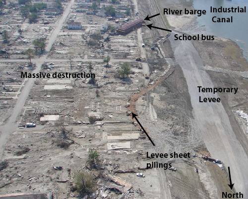
Figure 3. View of the southern 9’th Ward levee breach. The force of the water removed most of the houses and pushed the levee sheet piling far into the neighborhood. Photo by. L. Harder – ILIT Final Report(2006).
The Great New Orleans Flood of 2005
It total between 2000 and 3000 people lost their life due to Katrina. This will be the most expensive "natural" disaster in national history and one that will be remembered beside the 1906 Alaskan Earthquake, 1900 Galveston TX. Hurricane, the 1930’s Dust Bowl and the California Earthquakes. 85% of the entire city was flooded (Figure 4) and still today, only 50% of the people have returned to Orleans Parish. St. Bernard Parish was also hit hard and only 30% of its residence have returned.
Figure 4. Taken from the Times-Picayune Web site: Maximum standing water level. The maximum water level in paces was deeper at times, but the water moved on to flood other parts on the city.
Sources:
I obtained most of the following information from a field trip that Dr. Stephen Nelson from the University of Tulane put together. He produced a terrific Field trip guide (www.tulane.edu/~sanelson/Katrina/Hurricane Katrina Field Trip 11-12-06.pdf). I would recommend reading if you are interested in the levees and how they failed.
The Times Picayune (www.nola.com) has several reports over the flood. I grabbed the flood depth map from their Animated Flood time line (http://www.nola.com/katrina/graphics/wide.ssf?/katrina/graphics/flashflood.swf)
I also received some of this information from ILIT or the Independent Levee Investigation Team Final Report 2006. You can download their entire report (65 Megs) from the Berkley web site (http://www.ce.berkeley.edu/~new_orleans/). This is a detailed in-depth study of what went wrong and what can be done about it.
To log this Earth Cache:
To get credit for this cache, you must do the following. Please send me the answer to the last question, do not post on-line. Please post your picture in your find.
1. Location D: See if you can find the location of this picture ( hint: Sorry, the house with the green roof was demolished ). What does the area look like now? Take your picture looking down the street towards the new levee wall. Post your picture in your find.
2. Location E: Estimate the length of levee replaced in the 9’th Ward. A rough estimate will work; no need to get out the tape measurer. As you drive around, remember that there was 10+ feet of water here due to the break in the levee.
The reason for these caches is not to show the destruction, but to show the devastating effect on people and structures when a complete understanding of the geology is not taken into consideration. The sand deposits and the peat deposits under the levee are well known, but were partially ignored. The height of the levees was known to be to low and the sheet piling in places was known to be to high. Years before Katrina, scientists repeatedly said something like this would happen. They were ignored. With enough work, all of these levee breaches could have been prevented.
We all know better now, Right? Let us see what will be done about these problems.
I hope you learned something along the way.
Help thy Neighbor during times of trouble.
Take care, and keep on caching,
Oilman w/ Fuzzylogic.