Schwäbischer Muschelkalk EarthCache
-
Difficulty:
-

-
Terrain:
-

Size:  (not chosen)
Please note Use of geocaching.com services is subject to the terms and conditions
in our disclaimer.
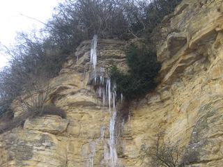
D: die Muschelkalkwand im Bietigheimer Enztal
E: the triassic shelly limestone wall in the Enz valley in
Bietigheim.
Deutsch:
In Bietigheim gibt es nahe des Eisenbahn-Viaduktes eine geologisch
ganz interessante Sache: Eine Muschelkalkwand, davor ein Lehrpfad
zur Erdgeschichte.
Die Wand ist 300 m lang und 20 m hoch und wurde durch Erosion von
der Enz abgetragen. Sie ist aus der Gesteinsschicht des oberen
Muschelkalks.
Vor etwa 215 - 205 Millionen Jahren, im Erdzeitalter der Trias,
entstand der Muschelkalk durch Meeresablagerungen. Fossile Muscheln
sind Namesgeber für diese Schicht. Das Gestein ist charakterisiert
durch hellgraue bis beige Farbtöne. Er ist nahezu überall im
Umkreis anzutreffen. Die Schicht wird grundsätzlich unterteilt in
Oberen, Mittleren und Unteren Muschelkalk. Interessant hierbei ist,
daß der mittlere Muschelkalk kaum Fossilien enthält, dagegen der
obere und untere zum Teil sehr viele. Ursache für die
Fossilienarmut der Mittelschicht war die Abtrennung des Gewässers
vom offenen Meer zu diesem Zeitpunkt!
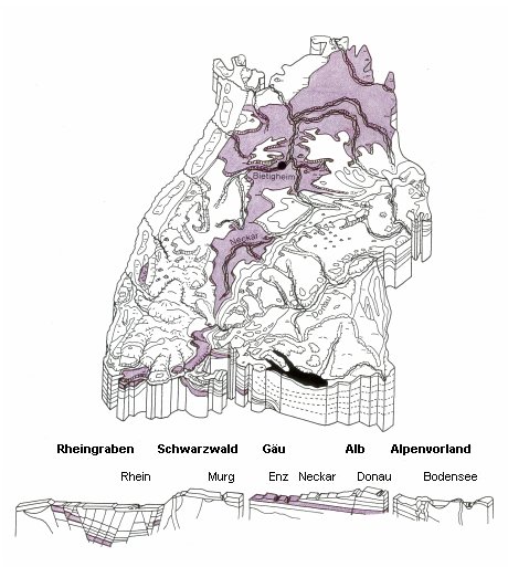
Vor der Wand liegt der geologische Lehrpfad. Er gibt Dir einen
Einblick in die Baden-Württembergische Schichtstufenlandschaft.
Hierbei spielt gerade im mittleren Neckarraum der Muschelkalk eine
zentrale Rolle. Mehr davon siehst Du auf den Tafeln des
Lehrpfades.
Um den Cache zu loggen, ist folgendes zu tun:
Informiere Dich anhand der Schautafeln über die geologische
Geschichte Baden-Württembergs.
Mache am besten auch ein Foto von der Wand, von einer der
aufgebauten Gesteinsformationen oder von der Erdzeituhr mit Dir
oder Deinem GPS.
Beantworte folgende Fragen anhand der aufgestellten
Schautafeln:
1. Durch welche Schichtstufe (außer Muschelkalk) fließt die
Enz?
2. Böden über Muschelkalkgestein sind oft sehr steinreich. Welche
Gäulandschaften haben mit ihrem Namen indirekt etwas mit
Muschelkalkgestein zu tun?
Schicke mir über GC die Lösung zu den beiden Fragen. Damit erteilst
du Dir selbst die Logfreigabe. Du brauchst keine Antwort von mir
abzuwarten. Du darfst nach dem mailen direkt loggen. Es wäre schön,
wenn Du auch ein Foto mit hochzulädst. Logs bei denen die Fragen
nicht beantwortet wurden, werden gelöscht!
Viel Spaß beim Erkunden.
English:
In Bietigheim near to the railway viaduct there is an interesting
object: A shelly limestone wall and infront of this a geological
trail.
The wall has a length of 300 m and a height of 20 m and was formed
by erosion of the river Enz. It is a shelly limestone layer of the
so called "Higher Muschelkalk"
215 - 205 million years ago, in the period of Trias, the shelly
limestone layer "Muschelkalk" was built by oceanic sediments.
Fossile shells were eponyms for this layer. It is characterized by
light grey to beige tones. It is found nearly all over around. The
layer is classified in Higher, Middle and Lower Muschelkalk. An
interesting detail is that the middle layer encloses nearly no
fossils, but the other layers a lot. Reason for this is the
separation of the water from the open see in this period of
time!
In front of the wall there is the geologic trail. It gives you an
overview of the escarpment landscape of Baden-Württemberg.
Especially in the region of middle Neckar triassic limestone plays
a main role. More of this you can see on the presentation boards on
the trail.
To log the cache you have to do following:
Visit the trail and inform you about the geological history of
Baden-Württemberg.
It would be nice to take a photo with you or your GPS either in
front of the wall, one of the installed rock formations or the
geological era clock.
1. What geological layer passes the river Enz (besides the
triassic limestone)?
2. Soil above triassic limestone very often is very stony. Which
name of ("Gäu-") landscapes has indirectly something to do
with triassic limestone?
Send a mail to me with the solution via GC. With this mail you give
yourself the approval to log. You don't have to wait for an answer,
you are allowed to log directly after mailing. Logs with missing
answers will be deleted! (If you have problems to answer the
questions because of the German descriptions on the presentation
boards plaese don't hesitate to contact me!)
Have fun with exploring!
Additional Hints
(No hints available.)