saga village portes artemisiou-ancient road Traditional Geocache
saga village portes artemisiou-ancient road
-
Difficulty:
-

-
Terrain:
-

Size:  (regular)
Please note Use of geocaching.com services is subject to the terms and conditions
in our disclaimer.
A very interesting and challenging cache found in the village Saga,( in the place "Portitsa") one of the most beautiful villages of mountainous Arkadia..(altitude:1100m.) I recommend to you visiting this beautiful region. Follow the waypoints to find the cache ! Leaving, you make sure that you have hidden well the cache.Happy geocaching !!
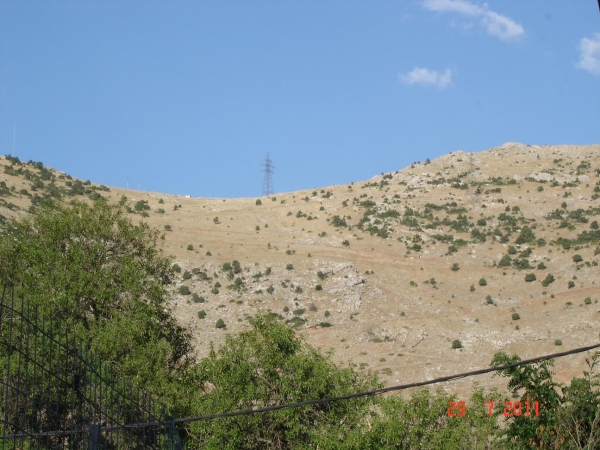 GREEK:προετοιμαστείτε κατάλληλα φέροντας τον απαραίτητο εξοπλισμό αφόυ η πεζοπορία διαρκει περιπου 1 με μιάμιση ώρα..Δίοδος Πορτίτσας ή Μαρμαρένια Σούδα Σύμφωνα με Έλληνες και ξένους ερευνητές: Ότι πιο σημαντικό έχει να παρουσιάσει η Πελοπόννησος από το αρχαίο οδικό δίκτυο. Πρόκειται για ένα γιγάντιο τεχνητό άνοιγμα ανάμεσα από τους Βράχους που λάξευσαν οι αρχαίοι. Μοναδικό μνημείο στον ελλαδικό χώρο. Βρίσκεται λίγο πιο νότια από τις Πόρτες ακριβώς στην κορυφογραμμή του βουνού σε υψόμετρο 1097,50 μ. Στη δίοδο της Πορτίτσας είναι εμφανή τα ίχνη της τεχνητής διάνοιξης, όπως ίχνη από «χονδρό βελόνι» και συναφή εργαλεία, καθώς και οι κάθετες αυλακώσεις του δαπέδου για να μη γλιστρά ο δρόμος. Πριν από την είσοδο της διόδου στη δυτική πλευρά της κορυφογραμμής (προς Σάγκα) σώζεται η κοίτη της αρχαίας οδού. Έχει πλάτος 2,20 μ. έως 2,50 μ. και ανεβαίνει με μικρή κλίση από τις Πόρτες. Επίσης είναι ορατά τα ίχνη του εκβραχισμού στο κράσπεδο της οδού. Το άνοιγμα του βράχου σε πλάτος είναι από 3,20 μ. μέχρι 5 μέτρα. Το ύψος της τομής του βράχου είναι από 1,50 μέτρα μέχρι 6 μέτρα. Το μήκος της διάβασης είναι 22 μέτρα. Στην περιοχή κοντά στη Δίοδο της Πορτίτσας έχει εντοπισθεί από τον ερευνητή Ηοννard, Ιερό των γεωμετρικών χρόνων, ίσως του Ερμή, γεγονός που αποδεικνύει τη διαχρονικότητα της διάβασης αυτής. Στην περιοχή, κατά την διάρκεια των ερευνών από την ομάδα εργασίας του αρχαιολόγου Γ.Α. Πίκουλα, βρέθηκαν λίγα άβαφα και ένα μελαμβαφές όστρακο (εντοπίσθηκαν όμως και ίχνη λαθρανασκαφής). Στα ίχνη της Διαδρομής της Κλίμακας πέρασε ο Φειδιππίδης, ο Αθηναίος ημεροδρόμος, στη μνημειώδη πορεία του προς τη Σπάρτη κατ' εντολή του Μιλτιάδη για να ζητήσει βοήθεια για λογαριασμό της Αθήνας που βρισκόταν προ της Περσικής απειλής.Η προσπάθεια αυτή του Αθηναίου αγγελιοφόρου Φειδιππίδη αναβιώνεται ως γνωστόν από το 1983 στα πλαίσια του υπερμαραθώνιου αγώνα με το όνομα «ΣΠΑΡΤΑΘΛΟΝ». Η διαδρομή της Κλίμακος από το Σάγκα μέχρι την Δίοδο της Πορτίτσας είναι μοναδική εμπειρία για τον επισκέπτη. Η θέση του Βράχου της Πορτίτσας στην κορυφογραμμή προσφέρει πανοραμική θέα στην περιοχή και στην Εθνική οδό που βρίσκεται χαμηλότερα. ENGLISH:Prepare your equipment well: take with you enough water and food, good hiking shoes and clothes, because the hiking time is about 1,5 hour.I hope you will enjoy this cache, and the view, and sure it will be one of your favorites! .This is the Passage of “Portitsa” or “Marmarenia Souda”. According to Greek and foreigner researchers it is the most important and remarkable that Peloponnese has to present from the ancient road network. It is a gigantic artificial opening between the Rocks where ancient greek people hewed. Unique monument in the hellenic space. It is little more southernly found by the point “Portes” precisely in the ridge of mountain in altitude 1097,50 m.In the passage of “Portitsa” the traces of artificial opening up are obvious, as traces from a large carving , and relevant tools, as well as the perpendicular grooves of flooring in order to to prevent slippage on the road. Before the entry of passage in the western side of ridge (to [Sagka village]) the watercourse of the ancient] road is saved . Also the traces of rock-removal are visible in the fringe of the road. The opening of rock in width is from 3,20 m. up to 5 metres. The height of section of rock is from 1,50 metres up to 6 metres. The length of crossing is 22 metres,In the traces of Way of Scale passed Pheidippides , Athenian runner, in his monumental course to Sparta at command of Miltiadis in order to ask help on behalf of Athens that was found before the Persian threat.This effort by the Athenian messenger Pheidippides is revived as you know, since 1983,under ultra marathon race with the name "Spartathlon".The route to the cache is a unique experience for visitors. The position of the Rock Portitsa the ridge offers panoramic views of the area and the highway is lower. From up there, the eye is gone, lost and travel freely back to the past and things to come in the future.... Watch out for muggles and try not to be seen by them,(hunters, shepherds,etc.),beacause they may follow you and destroy the cache....Please, after visiting and logging, hide well the cache exactly as you found it. The ancient road:
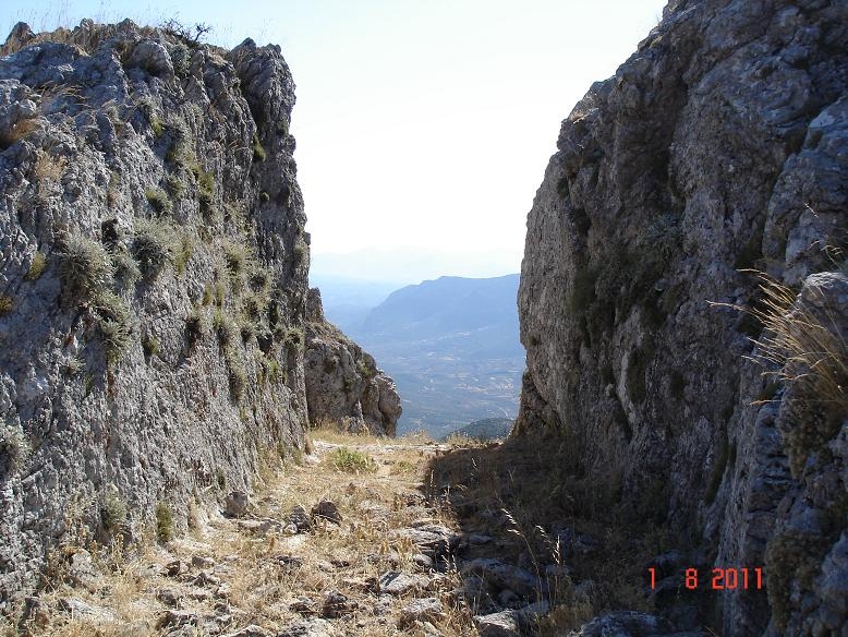
Additional Hints
(No hints available.)