|
   |
|
|
| Map |
 |
| Budapest |
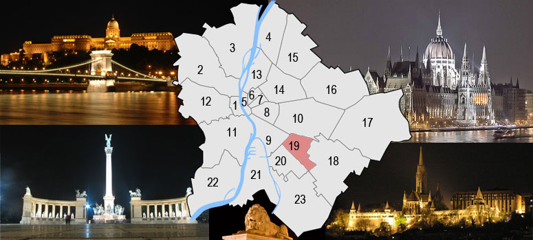
Budapest is a city of multiple characters, different geographical areas and of wide variety of architectural styles. The current city was established on 17th November, 1873 by the unification of the settlements of Pest, Buda and Óbuda on the banks of the Danube river. Budapest had 10 districts after coming into existence in 1873, numbered 1 to 10. In the 1930s, 4 new districts were organized, numbered 11 to 14. On 1st January, 1950, Budapest was united with 7 neighbouring towns and 16 villages, hence the number of its districts increased to 22. In 1994, one of the former villages left district 20 in order to form the 23rd district. Budapest's current 23 districts extend to an area of 525 square kilometres (202.7 sq mi). Most of the districts have a special flavour - from a posh downtown area one can get easily into the hilly districts of Buda or to the green suburbs of Pest. Several districts still bear the marks of the enforced industrialization of the 50s and 60s. City parks, forests of the Buda Hills, boat-houses along the Danube, flowery islands, shipyards and chemical plants, the Royal Castle and prefab housing estates are all part of this wonderful city.
The Great Budapest Geocaching Adventure guides you through all 23 districts with the goal of displaying the most typical or most unique sites in each of them. In each cache there is a code you need to uncover for the real coordinates of the bonus cache. You can find the codes on the inside of the lids of each cache container and in the logbooks. Happy caching. |
| 19th district |
| Kispest (literally Little Pest) is the 19th (XIX) district of Budapest,. It lies to the south-southeast of the historical Pest city. It was founded in 1871 on rural land as a small village beside the city limits of Budapest, so it was named Kispest (Little Pest). From 1880 to 1990 Kispest's population increased from 1820 to 72,838. Kispest became part of Greater Budapest in 1950. The district is served by the Metro 3 (Kobánya-Kispest and Határ út stations), so the connection with the Downtown is rapid. Ferenc Puskás played football for Kispest F.C. (then called Kispest Honvéd FC) in the 1950s. Kispest is graced by an elegant residential area called Wekerle (named after the Hungarian premier at the time of the development in the 1920s, Sándor Wekerle). This kilometer square of quiet criss-crossing streets has much greenery. |
 |
|
|
| The hiding place |
| Wekerle Estate, XIX district. The 'Hungarian Garden Suburb' was built to house more than 20,000 people (lower middle class public servants). It does not only provide residential units but has been planned to provide for all the needs of people settling there. Apart from shops and schools, adult education and cultural amenities were also provided. This estate for industrial and white collar workers occupies a unique place in the architectural history of Hungary. The idea of the housing estate was initiated by Prime Minister Sándor Wekerle. The winning design drew up a ring street system composed of diagonals. All these street led to a central square. The special lane system of the street resulted in stressed intersections street corners and triangular squares. These points marked the sub- centres where the public buildings were erected. The main square with the surrounding biuldings were nearly ready by 1912, however the entire project was completed by 1926. Its architect, Károly Kós (1883-1977) was a Transylvanian born Hungarian architect, etnographer, designer, writer and politician. He graduated from the Budapest Technical University. He started his studies as an engineer, but he finished as an architect. He took a study trip back to Transylvania, when he was an university student. The young architect worked in different architectural studios and took interest in the Transylvanian vernacular architecture. He has produced many significant buildings over his long career, including residential buildings, schools, churches and specail buildings (like the ones in the Zoo). |
| Approaching |
 BUS 148 from Kobánya-Kispest or BUS 99 from Blaha Lujza squre (visit Bus 148 link). BUS 148 from Kobánya-Kispest or BUS 99 from Blaha Lujza squre (visit Bus 148 link).
or (visit Bus 99 link)
 Accessible by bike. (visit link) Accessible by bike. (visit link)
 free parking close to the cache free parking close to the cache
|
| Budapest |
| Budapest ist eine Stadt bunten Charakters, unterschiedlicher geographischer Zonen und einer breiten Vielfalt an architektonischen Stilen. Die heutige Stadt wurde am 17. November 1873 durch Zusammenschluss der Städte Pest, Buda und Óbuda, die an beiden Ufern der Doanu liegen, gegründet. Budapest hatte damals 10 Bezirke, nummeriert von 1 bis 10. In den 30er-Jahren kamen 4 weitere Bezirke (11-14) hinzu. Am 1.Jänner 1950 wurde das Stadtgebiet um angrenzende 7 Städte und 16 Dörfer erweitert, die Zahl der Bezirke erhöhte sich damit auf 22. 1994 wurde eines der früheren Dörfer aus dem 20. Bezirk ausgegliedert, womit ein neuer 23. Bezirk enstand. Die derzeit 23 Bezirke haben eine Ausdehnung von insgesamt etwa 525km² (202,7mi²). Die meisten dieser Bezirke haben ihren unverwechselbaren Charakter - von repräsentativen Innenstadtbereichen über die hügeligen Bezirke von Buda bis hin zu den erholsamen grünen Vorstädten von Pest ist alles zu finden. Einige Bezirke stehen bis heute im Zeichen der stark forcierten Industrialisierung der 50er- und 60er-Jahre. Stadtparks, die Wälder der Budaer Berge, Bootshäuser entlang der Donauufer, blütengezierte Inseln, Werften und Chemiebetriebe, die königliche Burg und auch Fertigteil Wohnhausanlagen sind alle Teil dieser wundervollen Stadt. Das Große Budapester Geocaching Abenteuer wird durch jeden der 23 Bezirke führen und versuchen, in jedem etwas Typisches oder Einzigartiges zu zeigen. Jedem, der alle 23 Caches besucht, winkt als Draufgabe ein BONUS-Cache. Happy Caching. |
| Bezirk 19. |
| Kispest („Klein Pest“) ist die Bezeichnung für den 19. Bezirk in Budapest. Das Gebiet war bereits vor der Zeit der Landnahme besiedelt. Es wurden beispielsweise Spuren awarischer Siedlungen gefunden. Zur Zeit des Mongolensturms wurden die Siedlungen zerstört. Danach diente das Gebiet jahrhundertelang als königliches Jagdrevier, zum Beispiel unter Matthias Corvinus. Im Jahr 1723 geriet der Szentlorinc puszta genannte Bereich in den Besitz von Antal Grassalkovich I., mit dessen Namen unter anderem der Bau einer Kapelle verbunden ist. Nachdem die Familie Grassalkovich ausgestorben war, wechselten die Besitzer des Gebiets mehrmals. 1880 betrug die Zahl der Einwohner 1800 Personen, die verschiedenen Nationalitäten angehörten. Kispest erlebte während der industriellen Revolution einen Aufschwung. Diese Entwicklung wurde auch nicht gebremst, als Pestszentlorinc 1909 von Kispest abgetrennt wurde. Kispest ist am 1. Januar 1950 mit dem Anschluss der bis dahin eigenständigen Stadt Kispest entstanden. Gleichzeitig ist es der Name des größeren der beiden Stadtteile, aus denen sich der Bezirk zusammensetzt. |
|
| Das Versteck |
| Wekerle-telep (ungarisch für Wekerle-Siedlung) ist ein Stadtviertel im Südosten Budapests neben Kispest und Pest-Erzsébet. Die Gartenstadt aus ungefähr 1.000 Häusern wurde zwischen 1908 und 1924 für öffentliche Bedienstete der Stadt Budapest errichtet und besteht aus mehrheitlich einstöckigen Häusern mit Gärten in einem Geflecht breiter rechwinkliger und diagonaler Alleen. Sie ist ein sehr frühes Beispiel einer tatsächlich gebauten Gartenstadt außerhalb Großbritanniens und wird auch heute noch mehrheitlich von mittelständischen Beamten bewohnt. Das Zentrum bildet ein Park, der nach dem Hauptarchitekt der Siedlung, Károly Kós benannt wurde, um den herum die öffentlichen Gebäude angelegt sind. Die Siedlung wurde nach Dr. Sándor Wekerle, dem ersten nichtadeligen ungarischen Ministerpräsidenten, benannt. |
| Verkehrsverbindung |
mit dem Bus 148 bis Kós Károly tér(visit link).
Fahrrad-Zugang (visit link)
Free parking next to the cache
|
| Budapest |
| Budapest ezerarcú város, melyet földrajzi változatossága és építészeti sokszínusége varázsol egyedivé. Az 1873. november 17-én Pest Buda és Óbuda egyesítésével létrejött akkori fovárosnak 10 kerülete volt, amely az elkövetkezo évtizedek során fokozatosan bovült a mai 23-ra. A város ma 525 négyzetkilométeren terül el. A különbözo kerületek a folyamatos fejlodés és átalakulás mellett továbborzik sajátosságaikat, a Belváros csillogó bevásárló utcái, Buda dombvidéke vagy a pesti zöldövezet lakónegyedei mind sajátos hangulattal bírnak. A város arcát továbbra is sebhelyként csúfítják az 50-es 60-as évek eroltetett iparosításának "emlékmuvei". Zöld parkok és ligetek, a Budai hegyvidék erdoi, Duna-parti csónakházak, virágos szigetek, hajógyárak és vegyi üzemek, a Budavári palota és panel lakótelepek - ez mind Budapest. A Nagy Budapesti Geocaching Kaland végigvezet mind a 23 kerületen bemutatva az adott városrész legjellegzetesebb vagy éppen a legfurcsább vonását Ha mind a 23 ládát megtalálod, indulhatsz a BONUS csésze megkeresésére. Kalandra fel! |
| 19. kerület |
131 éves városrész Dél-Pest szívében. A 9.38 négyzetkilométer területén, közel 70 ezer lakosa van.
A mai Kispest és környéke a 18. sz. közepétol a 19. sz. közepéig a gödölloi Grassalkovich-uradalom Szentlorinci majorsági központjához tartozott. Kispest 1871. június 11-étol önálló kisközség lett. 1873-ban a szomszédos Törökfalva, majd a Vecséstol különvált Pestszenlorinc csatlakozott Kispesthez. 1874-ben nagyközség lett. 1950. január 1-jén csatolták Kispestet Budapesthez. |
|
| A rejtek |
A láda Kispest egyik legjellegzetes részére, a Wekerle-telep közepén található park szélére került.
A telep tervezésekor, s építésekor kiemelten törekedtek a kertvárosi hangulat megteremtésére.
Széles utak, gondozott fasorok, parkok teszik kellemessé az itt élok mindennapjait.
Aki nem járt még itt, annak is érdekes látvány lehet térképrol a városrész szabályos uthálózata.
A Pénzügyminisztérium megbízásából Gyori Ottmár készített kivitelezheto tervet, a nyertes pályamuvek felhasználásával. Gyori Ottmár lett a telep foépítésze és elso gondnoka. A típusépületek tervezésében a díjnyertes pályamuvek alkotói vettek részt.
A Wekerlérol bovebben |
| Megközelítés |
|
148-as busszal Kobánya-Kispesttol a Kós Károly tér-ig (menetrend).
vagy 99-es busszal a Blaha Lujza térrol a Kós Károly tér-ig (menetrend).
Bicajjal megközelítheto (térkép)
Ingyenes parkolás a közelben
|