Kapt Undies spotted this article in an old tramping book, and
brought it to my attention. Damn, now we had to do it! But to
really do it justice, we decided to leave it until the middle of
winter. With three consecutive storms in a week passing through and
leaving the Coromandel all but cut off due to flooding and
landslips, we decided then was the perfect opportunity. We mustered
together a motley crew of five alpine club masochists and headed
out into the abyss. After the exciting drive through the mostly
submerged Hauraki plains, we were a little disappointed with the
much anticipated mud wallow. The bush bash, however, exceeded all
our expectations. We completed the mere 14km in the blistering time
of 7 hours. Not bad considering that when this article was
published all those years ago, there was still a track up there!
Needless to say, it is now much, much worse.
In fact we ‘enjoyed’ it so much, Kapt Undies and I
did it again. This time in the summer, and the mud was still there.
This time it took us 9 hours after taking in the scenic side
excursion to Moss Creek campground, placing the cache, and
"exploring alternative destinations" (yeah, OK - getting lost).
Kapt Undies enjoying one of the easier sections -
this is as good as it gets!
Warning - this is no woosie drive by cache placement. To
complete this mission you not only need to be both physically and
mentally tough (sick?), but you also really need to know what the
hell you’re doing out there - if anyone can work out the
answer to that one I’d love to know! You will not be able to
see any landmarks to navigate by, so make sure you have your
waypoints loaded, spare batteries, and a map and compass as a back
up. Oh, and a headtorch for when you get lost anyway, and sticking
plasters for when you fall over and grab the cutty grass by mistake
- again. A PLB could be useful for when you simply give up and
can't take any more. The one saving grace is that I found satellite
coverage to be excellent!
Park your car at the end of the road and head towards the
Pinnacles hut. Turn off left after 20 minutes towards Moss Creek
campground. There is a steep scramble up to the Mt Rowe turnoff.
You can either carry on for 10 minutes to the campground where
there is a cute two bunk hut ("sorry ladies, this is only a two man
hut" - yeah right!) with pots, plates, cutlery, water, gas, and
actual dry tent sites; or turn left towards Mt Rowe. The campsite
is signposted 3 hours from the carpark, but it only took us about
half that. I would recommend skipping the campsite, because you
REALLY don’t want to be lugging a big pack the rest of the
way. A better idea would be to camp down nearer the carpark so you
can get an early start in the morning and travel light. Remember
the times I've mentioned only apply to gerbils - you may find it
takes considerably longer!
Slime your way up Mt Rowe, and savour the track while it lasts.
If you think this is bad, prepare yourself for the terror that is
about to unfold. After the summit, it is bush bashing like
something from your worst nightmare come true, right across Table
Mountain and down the other side. It took us 6 hours to walk the
4kms from Mt Rowe to the other side! You will be either wading
through mud or climbing over and under fallen trees whilst bashing
through cutty grass most of the way. Mind you, on our last trip, we
did it in shorts and short sleeves, so you can probably still
simply follow our trail of blood...
The cache is a 10 litre pail hidden under an overhanging tree
(see spoiler photo) right in the middle of the Table Top (see map).
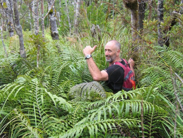
You may notice something very unusual about this tree:
Yes, a track marker! This is quite possibly the only one you
will see the whole way between the two tracks. We did manage to
find a little bit of the old track here, complete with marker lying
on the ground nearby, so I thought this would be a good spot to
bring you back to when you have absolutely no idea where you are
anymore. Plus I can honestly say "you do not need to step off the
track to retrieve the cache" (he he). The cache even contains
useful things you may need, such as a torch, sticking plasters, dry
socks... Please ensure the lid is clicked down completely and the
bucket covered again - I really don’t want to come back here
any time soon!
At the far end of the Table , there is an old DOC log book on a
stand (see coordinates below). When we opened the lid, a huge weta
jumped out, followed by an enormous gecko, which, going by previous
logs is obviously a resident here. From here it’s all
downhill, but the nightmare is only just beginning. The terrain is
steep initially and you’re then faced with bastard grass and
walls of impenetrable supplejack. Maybe even a bit of bush lawyer
to make it interesting. But don’t worry, the track is near at
hand...
When you do eventually find ‘the track’ (look
carefully for the white markers), this will lead you to a nice
Kauri, after which the track is actually maintained. Yeah Baby!!
Eight easy stream crossings later and you’re back at the
road.
Special thanks to Kapt Undies for being the bulldozer out front
and slapping me when I started screaming 
This is extreme geocaching, and you need to be one
seriously sick puppy to even think about doing this. Although no
specialised equipment is required (a machete and snorkel may be
useful though), this still gets a genuine GuanoGerbil 5 star
terrain rating for sheer pointlessness.
IT MUST BE DONE!!
Congratulations to TFM and Boges on your FTW (first to
wallow)!
Update February 2011 I still can't believe I got talked
into doing this again - for the 3rd time! Calling me a wimp,
threats of vandalising my cache and taunts of me never actually
bagging the true summit before (how can a swamp have a summit?!)
all conspired against my better judgement of previously vowing
never to return. This time around we were somewhat disappointed to
find an actual track marked by pink tape from Mt Rowe up onto the
Table top. It was beginning to look like the name may have to be
changed to merely The Somewhat Unpleasant Tramp. We were oddly
relieved to find the track stopped up on the top and still left us
with a couple of hours of good old fashioned full-on bush bashing
across to the other side. Check out Vinodrinkers
epic video of the day to get an idea of what you will be
confronting.
We found the new marked track down the other side too this time,
complete with the couple of oddly placed cables. Turn left at the
DOC logbook a short distance (if you reach the landslip you've gone
too far). Follow the markers down the ridgeline (if you get bluffed
out, backtrack briefly and look for the marker going down on the
right when facing downhill) which brings you to an awesome new
superhighway at the bottom. This links up with the old track at the
second kauri tree. No stream crossings now - beautiful new bridges
and track the whole way back.