
 Outcrops of the Neenach Formation are located on private land. This Earthcache is to give perspective to the Pinnacles Eartchcaches (GC70468 and GC70465) about 195 miles to the north. There is safe ample parking by the mailboxes on the west side of the road.
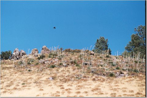
Near the top of the hill to the east of this stop are a few outcrops of the Neenach Formation. It is a dark reddish to purplish brown andesite. Unfortunately, because all the outcrops in the area are on private land you can't get a close look at them.
From a distance, the weathering and geomorphology of these outcrops looks similar to the pinnacles of the Pinnacles National Monument, only much smaller.
The formation of these rocks begins about 60 million years ago. At that time, an oceanic plate (a piece of the crust of the earth) called the Farallon Plate and the continental North American Plate were moving toward each other. Instead of crunching together like two cars, the Farallon Plate was directed down into the earth while the North American Plate stayed on top. This plate movement of an oceanic plate diving down under a continental plate is called subduction.
During the subduction, portions of the Farallon Plate were scraped off the top and pushed up against the edge of the North American Plate forming much of the north-south coastal mountains. As the Farallon Plate went deeper in to the earth, it began to melt under the North American Plate. The melting Farallon Plate formed large amounts of magma (melted rock) that moved up through weak areas along the edge of the North American Plate forming volcanoes.
It is estimated that the volcano that formed became active about 22 to 23 million years ago, the Miocene. While it was active, it formed an estimated 8,000 foot high mountain, 15 miles long and 5 miles wide. David Warburton of Florida Atlantic University puts that as a little smaller than Mt. St. Helens.
At some point, the North American Plate migrated over the spreading center that was the boundary between the Farallon and Pacific Plate. The spreading center is a plate margin where the plates are constantly moving away from each other and magma is continually filling in the space between them. Once that happened, the Farallon Plate no longer existed, and the volcano became extinct.
Instead of moving toward each other, the Pacific Plate was moving northwest relative to the North American Plate. This changed the plate boundary to the transform fault we are familiar with today. As it happened, the volcano ended up straddling the fault line that formed between the plates.
It is estimated that the Pacific Plate has moved approximately 1.5 inches per year resulting in the portion of the volcano on the Pacific Plate moving 195 miles northwest to become the Pinnacles National Monument relative to the rest of the volcano that is on the North American Plate, where you are now.
An additional location to see outcrops of the Neenach is at N34 46.639 W 118 40.409. The outcrop is up the hill to the south way across the field on private land. I would suggest binoculars for this one.
Logging requirements:
Send me a note with :
- The text "GCQ5FZ Neenach Formation - Other Half of Pinnacles" on the first line
- The number of people in your group.
- where you see outcrops of rock similar to the one at the coordinates.
- Why the outcrops tend to be at the elevation they are and why you think the Neenach formation doesn't look like the Pinnacles.
The above information was compiled from NPS documentation and the following sources:
- National Geologic Map Database, USGS, Summary of Citation: Neenach Publication: Dibblee, T.W., Jr., 1967, Areal geology of the western Mojave Desert, California: U.S. Geological Survey Professional Paper, 522, 153 p., (incl. geologic map, scale 1:125,000) (http://ngmdb.usgs.gov/Geolex/Refsmry/sumry_11424.html)
- Geology of National Parks, GLY 3164, © 2004 by David L. Warburton (http://www.geology.fau.edu/Resources/CourseWebPages/Fall2004/GLY3164/NPPINNNM.htm)
- San Francisco Bay Area Network I & M Program Monitoring Report: Phase I October 2002 version 8/15/2005 Jennifer Bjork http://www2.nature.nps.gov/geology/parks/pinn/#geology
- Stanley, Richard G., et. Al. , 2000, Locaitons and Ages of Middle Tertiary Volcanic Centers in Coastal California, Open-File Report 00-154, USGS http://vulcan.wr.usgs.gov/LivingWith/VolcanicPast/Places/volcanic_past_california.html