Vanovsky vodopad/Vanovsky waterfall EarthCache
Vanovsky vodopad/Vanovsky waterfall
-
Difficulty:
-

-
Terrain:
-

Size:  (other)
Please note Use of geocaching.com services is subject to the terms and conditions
in our disclaimer.
Vanovsky vodopad/Vanovsky waterfall
[EN]
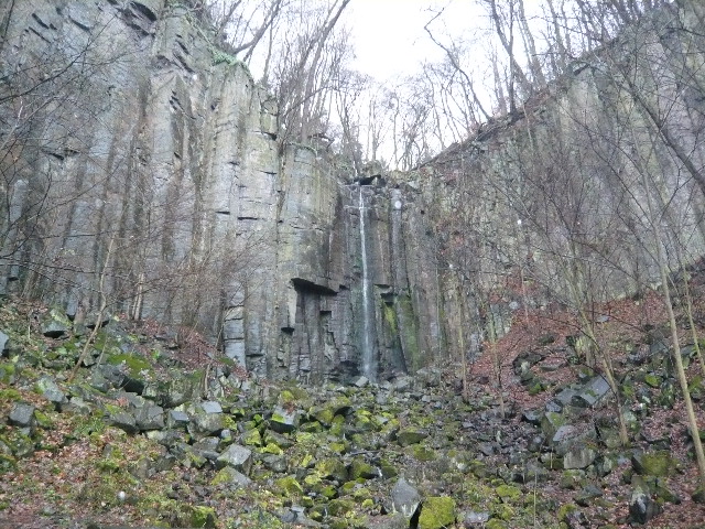
This is a natural monument, which is located near Usti nad Labem.Situated in a wooded area near the national nature monuments Vrkoc (441.mnm) and is the largest waterfall in the Czech Stredohorí. Basement natural attractions is made up of santons sandstones, the youngest sediments chalk Central Bohemian Highlands. They pale ocher, even white sometimes tinged iron compounds. Have a significant clay content of impurities and easily weather.V Miocene basalt punctures were magmatem. His spread on the surface sandstone were coping, freezing inside the sandstone layers of veins.Cool down rock burst on pillars oriented perpendicular to the surface freezing point. Cap, hold the edge of the waterfall in the impressive rock amphitheater, has a huge vertical, each other perfectly parallel columns with a diameter of one to two meters.
The variety of shape and landscape individual nature occurred gradually volcanic activity, but not all at once. The first phase occurred more about 25 million years in the Tertiary, when it was in connection with the massive vrinkle in southern Europe this area strongly tectonically violated. Created the fractures extends into the depths 60-200 km. Such breaks have become natural channels for output of hot liquid magmatu on surfaces. The first phase of volcanic fairly drops pans in which there was a strong coal activities. The second, but much weaker phase of volcanic activity occurred about 10-15 million years.
In winter, when the waterfall freezes is a common objective mountaineers climbing. Green tourist path leading from the foot of the waterfall to the prospect. Right at the start on the right side of the road is carved into the rock date of the 19th 3rd In 1916 with an inscription to the memory of Austrian engineer who built this way.
For the recognition of the logs is a need to find the following information:
1)How is the height of the waterfall
2)What is altitude river and the river Elbe
3)Latin name snail living in the creek and its size
4)Take photo of you and your GPS with a waterfall in the background.
All the necessary information can be found on the board of the waterfall. Send answers via a profile on geocaching.com.
The logs which will not comply with the requirements will be deleted.
[CZ]
Jedná se o prírodní památku, která se nachazí nedaleko od Ústí nad Labem.Leží v zalesnené oblasti poblíž Národní prírodní památky Vrkoc(441.m.n.m.) a je nejvetším vodopádem v Ceském Stredohorí. Podloží prírodní památky je tvoreno santonskými pískovci, nejmladšími krídovými sedimenty Ceského stredohorí. Mají svetle okrovou, místy až bílou barvu obcas zabarvenou železitými slouceninami. Mají znacný obsah jílovitých prímesí a snadno zvetrávají.V miocénu byly proraženy cedicovým magmatem. Jeho rozlivem po povrchu pískovcu vznikly príkrovy, tuhnutím uvnitr pískovcových vrstev žíly a pne.Chladnoucí hornina rozpukala na sloupy orientované kolmo k ploše tuhnutí. Príkrov, z jehož okraje prepadává vodopád v impozantním skalním amfiteatru, má svislé mohutné, vzájemne dokonale soubežné sloupy o prumeru jeden až dva metry.
K tvarové pestrosti a krajinnému osobitému rázu docházelo postupne sopecnou cinností, která však neprobehla najednou. První silnejší fáze nastala asi pred 25 milióny let ve tretihorách, kdy byla v souvislosti s mohutným vrásnením v jižní Evrope tato oblast silne tektonicky porušena. Vytvorily se zlomy sahající do hloubek 60-200 km. Tyto zlomy se staly prírodními cestami pro výstup žhavého tekutého magmatu na zemský povrch. První vulkanickou fázi vystrídaly poklesy pánví, v nichž došlo k silné uhlotvorné cinnosti. Ke druhé, ale již podstatne slabší fázi vulkanické cinnosti došlo asi pred 10-15 milióny let.
V zime, když vodopád zamrzne je castým cílem horolezcu holdujícím ledovcovému lezení. Zelená turistická cesta vede od úpatí vodopádu k vyhlídce. Hned na zacátku na pravém strane cesty je do skály vytesán datum 19. 3. 1916 s nápisem na pamet rakouských zákopníku, kterí tuto cestu postavili.
Pro uznání logu je treba zjistit následující informace:
1)Jaká je výška vodopádu
2)Jaký je výškový rozdíl potoka a reky Labe
3)Latinský název plže (prichycen na kamenech) žijícího v potoce a jeho velikost
4) Vše potrebné lze najít na informacní tabuli u vodopádu.Odpovedi posílejte pres profil na geocaching.com.
V souladu s pravidly budou smazány logy, nesplnující uvedené podmínky.
[S logováním nemusíte cekat na schválení odpovedi,postupne vše prekontroluji.]
[Posílejte odpovedi zjištené na tabuli.Informace získané z internetu nekdy neodpovídají tem které požaduji.]

Tato earthka je zarazena do serie Vodpády 
Additional Hints
(No hints available.)