
A Powerful Stream
This cache was brought to you with the help of the geoslider
that likes rocks, fossils, and everything geological. It is in the
small Ashford Glen Preserve, nestled between the roads of a
development and property that is owned by the Latham Water
District. Please respect the area as the stewards of this preserve
have had to deal with vandals in the past. Stay on the trails as
long as you can and do your best not to create any herd paths.
For this Earthcache you will need to read the information below
an, using your own skills of interpretation, find the correct
areas, do a couple of calculations and offer your best educated
guess at some questions. There are no signs to find for the answers
– just read, learn and do. Part 2 involves some significant
terrain that must be done carefully, hence the terrain rating.
Please note that there are two parts to this Earthcache.
To claim this cache you will need to do all five parts.
Most of us are familiar with how stream erosion works. We know
that the scale can be small or amazingly large, such as Grand
Canyon. This Earthcache will show you two stages of stream
erosion.
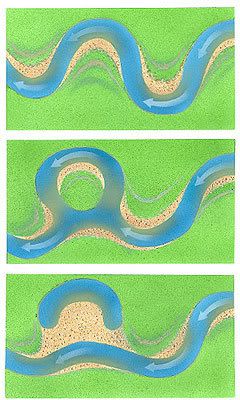
OXBOW LAKE FORMATION
In a stream, water flows the fastest at the outside bends and
the slowest on the interior bends. As it flows along the outside
bend it erodes away soil, small rocks and other particles. Over
time, the outside bend is eroded into a “river cliff”
which is visible at this locale. Also, over time the river deposits
material along the inside bends – this is also evident at
this locale.
As the river continues to erode its outer banks and deposit
along its inner banks, it begins to “meander”.
Meandering is the classic snake like river shape commonly seen in
many river environments. The erosion and deposition continue and
new areas of bank are formed while the outside bend is eroded to
the point where only a small neck of land is left separating the
two channels.
Eventually, typically during a flood event, the small strip of
land is broken through and an island area is created. You can see
this process at work at this locale as well – the neck is
still present and you can see where the island will be.
The last stage is where the oxbow has finally formed. Now that
the river has a straight path to follow (path of least resistance)
it no longer flows through the curved portions of the river. As it
flows through the straight channel it deposits soil and debris
along the banks. This deposition eventually cuts off the old
meandering portion of the river and forms an Oxbow Lake. Oxbow
Lakes often fill in over time and are only seen with water during
flood events.
Here is a picture demonstrating the steps described above:
So, now you have some background – how do you earn a
smiley? Answer the following three questions for the first part and
the two questions for the second part.
- Locate a river cliff section (more of a stream cliff here),
take a picture of it and upload the picture with your log
- Locate an area of deposition, take a picture of it and upload
it with your log
- Determine how long it may take for the stream to cut through
and form an oxbow. To simplify this calculation, we will assume
that the flow of the river erodes the banks at a rate of 6 cm per
year. Use this to determine how long it will take (measure the
current width/6cm)
Which came first the Valley or the Meander??
Stream/Rivers go through typical life cycles just like the rest
of us. For a stream, the cycle happens over and over again
throughout time. Although Geologists argue about certain portions
of the life cycle, the general stages are:
Stage 1: In the beginning a stream has a sharp, deepening
V-shaped valley, there may be waterfalls and/or rapids and
floodplains have not developed (deposition on interior bends
forming new land).
Stage 2: As the stream begins to age floodplains begin to form,
the valley widens, sand bars begin to form and the down cutting
(deepening) of the stream lessens.
Stage 3: In the next stage the valley has widened, a narrow
floodplain is evident and continues to develop and the river begins
to meander.
Stage 4: In the final stage, overall relief of the area is
generally flat, the river meanders significantly and oxbow lakes
may have formed. The river straightens out, and the cycle begins
again.
Using the information above go to N 42 46.108 W 073 50.007. At
this location:
- Measure the depth the stream has eroded down, take a
measurement at the bottom of the hill (near the stream bed) and the
top of the hill (trail-highest point) – email the difference.
This may be done more easily by walking along the stream bed to the
right point and then walking back along the bed to the trail and
taking the trail back up to the top.
- Email which stage of development you believe this portion of
the stream is at and WHY.
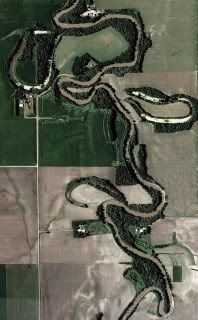
Here is a picture from Oxbow, ND. I wonder why they named it
Oxbow?
Please visit my other Earth Caches:
| I am a proud |
  |
Disclaimer: You, and all members of your party must read and
agree to the www.geocaching.com disclaimer. In addition, you all
must agree to hold the cache owner, www.geocaching.com, and the
landowners harmless from any and all causes for action. You and all
other members of your party must individually and collectively
determine your/their physical fitness and outdoors/hiking skill
levels, decide whether or not to visit the various cache locations,
and whether or not it is safe and prudent to do so under the
conditions that will be encountered. Cache seekers assume all risks
involved in seeking these cache locations.
People that do not wish to do a cache because of any danger they
might perceive to be present is certainly within their right to not
proceed. However you do not have the right to try to ruin the
enjoyment of others in attempting a find that is beyond your
capabilities, but not beyond theirs. This goes for almost every
caching event there is. After all one might run into spiders,
snakes, poisonous plants, trips and falls and the list goes on.
Safety First! .......Take a friend, Look out for others, take a
cell phone if possible, watch where you're stepping, NEVER UNCOVER
ANY CACHE WITH YOUR HANDS OR FEET, USE A STICK! If you feel
uncomfortable in doing a cache, for any reason, just walk
away!!!