Důl Jeroným / The
Hieronymus Mine
Důl Jeroným
Cínový důl Jeroným severozápadně od zaniklé obce
Čistá eviduje báňský úřad již v roce 1548. Roku
1551 propůjčuje král Ferdinand I. Čisté horní právo
a privilegia královského města, která byla dalšími
panovníky potvrzena a rozšířena. Město mělo
vlastní cínovou váhu, cínovou huť a právo volné
těžby dříví v královských lesích. Přes velmi
rychlý rozvoj těžby byly na počátku 17. století doly
ztrátové a udržovali se jen proto, aby Čistá
nepřišla o statut horního města. V roce 1847 se o
nich mluví jako o sešlých a také pokusy o obnovení
těžby v 19.-20. století skončily bez valného
úspěchu.

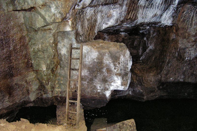
Podle odhadů poskytl důl Jeroným za celou historii asi
??? - ??? tun
cínu. Nebyl proto nikdy tak bohatý a věhlasný jako jiná díla v
okolí, ale zato se zachoval v původní podobě. V centrální
části dolu se nacházejí impozantní komory ze 16. století. V
řadě prostornou stěny a stropy zbarveny
černě od sazí, které se usadily při sázení
ohně. Stěny jsou zbrázděny rýhami po želízkách
a špičácích tehdejších havířů. Svou
rozlohou nemá důl konkurenci ani v saských cínových revírech.
Některé důlní komory dosahují délky třiceti,
šířky deseti a výšky až osmi metrů.
Jsou v nich patrné stopy po ohňové metodě dobývání rudy a
po práci želízkem a mlátkem.
V únoru roku 1990 byl důl Jeroným prohlášen za
státem chráněnou kulturní památku a v současné době
probíhají práce na jeho zpřístupnění veřejnosti.
Důl je významnou lokalitou Česko-bavorského geoparku,
jehož hlavním cílem je všestranně informovat o
geologické minulosti regionu, jeho nerostném bohatství, hornické
historii a přírodních zajímavostech. Česko-bavorský
geopark poukazuje na geologickou stavbu jako na podmiňující
faktor historického, ekonomického a kulturního vývoje lidské
společnosti. Podporuje přeshraniční spolupráci,
zvyšuje turistickou atraktivitu regionu a prohlubuje
sounáležitost lidí s jejich krajinou v srdci Evropy.
Pro uznání logu musíte splnit následující
úkoly:
- Přiložit k logu vaší fotografii nebo foto GPSky
u dolu Jeroným. (vstup nebo infotabule)
- Odpovědět na otázky:
1) Kolik se za celou historii v dole
Jeroným vytěžilo cínu? (infotabule)
2) Jaké další dva nerosty se
těžily kolem Horního Slavkova?
3) Kolik kamenů tvoří
portál vstupu do dolu?
The Hieronymus Mine
The Hieronymus tin mine southwest of the former town of Cistá
was already registered by the mining office in 1548. In 1551, King
Ferdinand I. granted Cistá mining rights and the privileges of a
royal town, which were acknowledged and expanded by subsequent
rules. The town had its own tin scale, tin smeltery and unlimited
logging rights in the royal forests. At the start of the 17th
century, the mines were not profitable in spite of the quick
development of mining, and were sustained for the sole purpose of
retaining the mining town status of Cistá. In 1847, they were
regarded as being dilapidated and attempts to revive mining
operations in the 19th and 20th centuries ended without any
significant success.

During the course of its history, the Hieronymus mine produced
approximately ??? - ??? tons of tin. Although the mine was never as rich
and renowned as other workings in the area, it has survived in its
original form. Imposing underground chambers from the 16th century
are located in the central part of the mine. In many places, the
walls and ceilings are blackened by soot, which accumulated from
fires that had been set. The walls are grooved by the moyles and
picks of miners from the past. Even mines in Saxon tin mining
districts could not rival its size. Some of the mine´s chambers,
which are up to 30 m long, 10 m wide and 8 high, contain noticeable
traces left by ore extraction methods using fire (firesetting),
moyles and malls.
In February 1990, the Hieronymus mine was declared a protected
cultural monument by the state and, currently, work is under way to
make it accessible to the public. The mine is a significant part of
the Czech-Bavarian Geopark. Its primary purpose is to provide
comprehensive information about the region´s geological history,
mineral wealth, mining history and natural landmarks. The
Czech-Bavarian Geopark shows that geological structure is an
underlying factor in the historic, economic and cultural
development of human society. It also promotes cross-border
partnership, increases the region´s tourist appeal and strengthens
the unity of people and their region in the heart of Europe.
To validate your log you need to accomplish
the following tasks:
- Attach a picture of yourself or your GPS near the Hieronymus mine
to your log. (entrance or information board)
- Answer the questions:
1) How much tin was extracted in the
history of Hieronymus mine? (information board)
2) Which two minerals used to be
extracted in the vicinity town of Horni Slavkov?
3) How many stones create the entry
portal to the mine?
Další informace / Other information:
Dějiny dolování cínu v Slavkovském
lese
Důl Jeroným
Zdroj / information: Česko-Bavorský Geopark
Foto: Island968