Update: The Falls Trail is closed beyond the Upper Falls. A major flash flood event in August, 2011 destroyed a portion of the trail leaving no safe access to areas beyond Upper Falls. This area will be closed to all access. Expect a shorter and easier hike and know that requirement 2 is no longer necessary or safe. Don't even think about it.
Bandelier National Monument is located in north-central New Mexico on the eastern side of the geologically young Jemez Mountains. Situated on the gently sloping Pajarito Plateau, Bandelier is bordered on the south by the Rio Grande and to the west by the San Miguel Mountains. Beginning about 30 million years ago, tension caused by movement in the earth's mantle created a huge valley, an immense tear that runs across New Mexico from Colorado to northern Mexico. Now known as the Rio Grande Rift, this pulling apart of the earth's crust resulted from separation along two parallel fault zones. The area near Bandelier is also crossed by the Jemez Lineament. The lineament is a line of young volcanoes that represent a weakness in the earth's crust running from east-central Arizona to northeastern New Mexico. These volcanoes include Mt. Taylor, the Jemez Mountains, and Capulin Volcano.
The Jemez Mountains are best known for two major volcanic eruptions, the first of which occurred more than 1.4 million years ago, and the second, a little over one million years ago. Together these eruptions were 600 times more powerful than the 1980 eruption of Mount St. Helens. Over 100 cubic miles of material was spewed out, covering over 1500 square miles with volcanic ash that was up to 1,000 feet deep in some areas. Ash clouds drifted as far as Iowa, Oklahoma, and Texas.
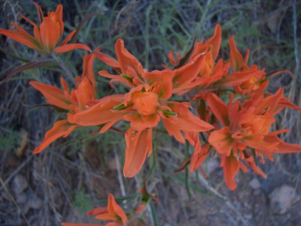
This EarthCache will take you along the Falls Trail following El Rito de Los Frijoles or Frijoles Creek through Frijoles Canyon where the creek eventually joins the Rio Grande. Frijoles Creek begins on the snowy slopes of the 10,199-foot-high Cerro Grande Peak. Carving its way down through the Pajarito Plateau for over fourteen miles before entering the winding Rio Grande, Frijoles Creek drops about 4,000 feet. This dramatic change in elevation on the Pajarito Plateau creates climate differences that support a wide diversity of life. This diversity made the area livable for the Ancestral Pueblo people, providing them with food, medicine, clothing, and supplies.
On your way down the trail you will notice the pinkish rock in the cliffs all around you. This is Bandelier Tuff. The tuff represents two very thick layers of volcanic ash. The bottom and top of each layer of the tuff cooled more rapidly than the interior layers and as a result remained fairly soft and easily eroded while the interior layers cooled much more slowly and became much harder and erosion resistant. The rock is composed of many bubbly fragments of volcanic ash, hard shards of volcanic glass, and irregular lumps of other volcanic material. In places it fills in older stream channels in older lava flows. As you descend into the canyon and get closer to the Rio Grande you will see darker layers in the walls composed of lava flows predating the Bandelier tuff.
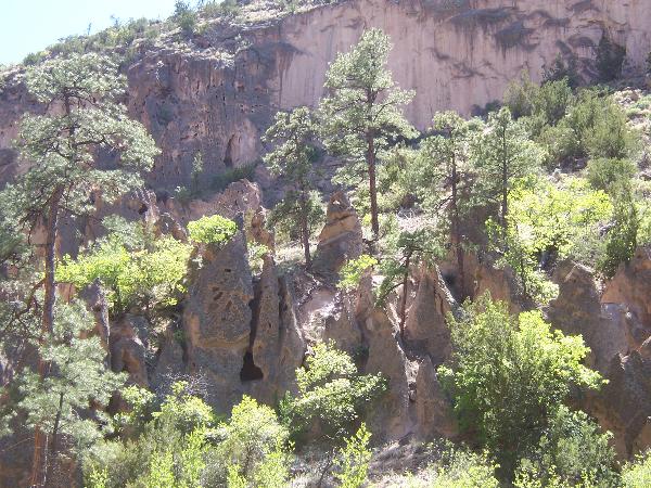
Along the trail in a couple of places you will notice cone shaped rocks, known as "tent rocks." These eroded remnants of tuff cliffs show the position of canyon walls at a previous time. There are several possible reasons why they form. Some may have been near an escape route of hot gases, where the additional heat welded the ash more tightly. Some still bear a capstone of harder material, which has slowed their erosion. Others may be protected from erosion by a resistant rind created by minerals deposited by ground water.
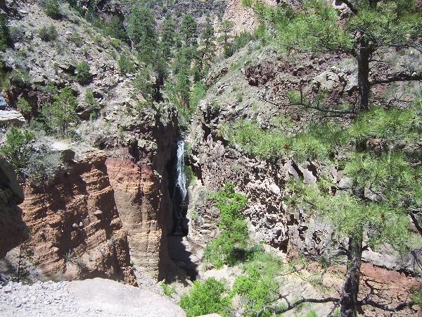
Along the trail you will also encounter the two waterfalls that give this trail its name. This area has the two main things needed for waterfalls - naturally water, and a gradient or change in elevation. At the Upper Frijoles Falls coordinates you will see the upper falls drop 80 feet over a resistant layer of basalt. As you descend below the first waterfall you will notice red-orange layers in the canyon walls resembling sandstone. This is also volcanic rock left by an ancient maar volcano. A maar volcano is a volcano that ejects lava through water such as a lake or stream. This volcanic material cooled very quickly as the lava was spit into the air and formed tight thin layers. At the Lower Frijoles Falls coordinates you will see the lower falls drop 40 feet over another resistant layer of basalt.
Please CHECK HERE for information about entrance fees, passes accepted, and seasonal closings.
From the parking area you may want to head into the visitors center where brochures for the self-guided trail are available for a small fee. I believe less than two dollars. Then head to the trailhead at the posted coordinates. The falls trail is narrow and uneven with sheer drops. The round trip distance to the lower falls is about 3.5 miles with a drop in elevation of over 600 feet that you will have to go back up on the return trip. Hikers should be in good physical shape and carry as much water as possible. The total round trip distance to the confluence of the Rio Grande (optional) is about 5 miles with a drop in elevation of over 700 feet. I have done the entire trail in the afternoon and would advise against going beyond the lower falls unless prepared. When I got down to the confluence the temperature was around 120 degrees and I used every last drop of the 160 ounces of water I carried in.
Parking Area - N 35 46.706 W 106 16.207
Upper Frijoles Falls - N 35 45.813 W 106 15.512
To claim this as a find:
1. Post a photo of yourself and your GPS with Upper Frijoles Falls in the background. (Optional but appreciated.)
2. Post a photo of yourself and your GPS with Lower Frijoles Falls in the background.
3. Post a photo of yourself and your GPS with tent rocks in the background. (Optional but appreciated.)
4. Estimate the circumference of the base of one of the tent rocks.
5. Use your log to describe, in your own terminology, the amount of water flowing over the upper falls (only) along with a quick description of the current weather conditions.
E-mail the answer to me for number 4, and post the photos and answer to number 5 with your log within a few days.
Good luck and good caching.
- Rev Mike