Sudbury Astrobleme! EarthCache
-
Difficulty:
-

-
Terrain:
-

Size:  (other)
Please note Use of geocaching.com services is subject to the terms and conditions
in our disclaimer.
-- THIS IS AN EARTHCACHE, READ BELOW FOR LOGGING REQUIREMENTS --
1.85 billion years ago, this was not a friendly place. Welcome to the crater rim of the second largest confirmed impact crater on earth.
The Sudbury Basin was created 1.85 Billion years ago when a 10km wide spacerock travelling 75 kilometers per second, gently nudged the area, causing this 250km wide crater, that was at one point 15-20km deep. Magma from the earths mantle filled the crater, creating the rich mineral deposits of Nickle, Copper, Platinum, Palladium, Aluminum and gold that Sudbury is best known for.
Astrobleme : "Star Wound", an ancient weathered impact structure
The impact was thought to be equivalent to 10 Billion Hiroshima Bombs, vaporizing the asteriod, and melting a large swath of the Canadian shield. Debris from the impact was spread over an area of 1.6 million square kilometers, and flung over 800 kilometers from the impact. If a similar incident were to happen today, the impact would instantly destroy all people, places and things within 800km of the impact, cause the earths atmosphere to be flooded with several thousand cubic miles of volcanic gas, sulpher, Carbon Dioxide and Monoxide, before igniting and wiping clean the entire continent in a bath of fire.
The impact crater is much smaller today (roughly 60km long, and 30 km wide). After 1.85 billion years of erosion, mountain building, a few hundred ice ages, and other natural events only the north-west rim of the crater remains fully intact. The formation of the Grenville and LaCloche mountains to the south pushed the southern rim of the crater northward, giving the crater and Oval shape. A subsequent meteorite impact 35 million years ago deformed the north-east section of the ridge - creating Lake Wanepeti.
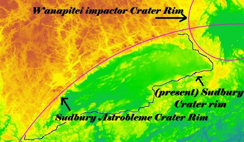
On the eastern side of the Sudbury Astrobleme is the Wanapitei impactor site - Another impact crater left by a much smaller impact only 37 million years ago. Local myths suggest that the lake is actually bottomless, but renowned oceanographer Jacques Cousteau determined that was not the case in various case studies of the odd lake. Contained within the lake is a gravitational anomaly called the Temagami Magnetic Anomaly, that generates a magnitude of over ten thousand nanoteslas - making it the strongest magnetic anomaly in North America. Some geologists believe the anomaly to be the original Wanepeti meteorite, while others believe it to be unrelated. One of many unanswered geology questions about the area.
The Sudbury Astrobleme is the second largest crater verified impact site on earth after the "Vredefort" in South Africa. It is larger then the much younger 3rd place contender "Chicxulub", the Dinosaur Killer in Yucatan Mexico.
Today the remenants of this impact run a 3 billion dollar a year mining industry in the area, producing over 900 million kilograms of Nickel, more then 10% of the world's consumption.
TO LOG THIS CACHE
Go to the Coordinates listed above. You will find a parking lot with many different types of stones, minerals and metal ores, with a description of how they were formed. Use the trail to travel down into the "High falls" area, and locate a "Wild" rock (there are plenty to choose from)
Take a picture of this "wild" rock, then identify it using the plaques and examples in the parking lot.
Your found log will need to contain:
- A picture of the "wild" rock (a rock in the wild) and coordinates
- A picture of the "captive" rock (a rock with a plaque in the parking lot)
- A brief description of what the rock is, use your own words! The plaque will help you with this, just put it into simple terms!

Click the logo to visit the COG website!
Additional Hints
(No hints available.)