
 This Earthcache uses a series of the nature trail stops
along the Palm Canyon Trail and expands on them to discuss the
specific aspects of the geomorphology, water cycle, and
weathering in the area. There are free nature trail guides
located at a kiosk near the trailhead that contain additional
information about the plants and wildlife you are likely to
see along the trail.
This Earthcache uses a series of the nature trail stops
along the Palm Canyon Trail and expands on them to discuss the
specific aspects of the geomorphology, water cycle, and
weathering in the area. There are free nature trail guides
located at a kiosk near the trailhead that contain additional
information about the plants and wildlife you are likely to
see along the trail.
Alluvial Fan
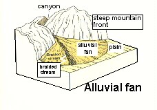 The initial location of the Earthcache is
located near the head (start) of an alluvial fan. An alluvial
fan is made up of sediment that is sporadically transported
out of a relatively narrow mountain canyon and deposited at
the mouth (end) of the narrow valley where it opens up into
flatter terrain. Typically, the streams in the canyons are
ephemeral (temporary) streams. However, you will find that
there is almost always water somewhere along this
stream.
The initial location of the Earthcache is
located near the head (start) of an alluvial fan. An alluvial
fan is made up of sediment that is sporadically transported
out of a relatively narrow mountain canyon and deposited at
the mouth (end) of the narrow valley where it opens up into
flatter terrain. Typically, the streams in the canyons are
ephemeral (temporary) streams. However, you will find that
there is almost always water somewhere along this
stream.
Image from wrgis.wr.usgs.gov/docs/usgsnps/
deva/9ADV-2.jpg (no longer active)
Water traveling in the narrow canyons moves quickly and carries
a lot of sediment, especially during flash floods. When the water
reaches the valley, it is no longer confined so it spreads out,
slows, and drops its sediment. Over time this generates a buildup
of sediment at the mouth of the narrow canyons that spreads out
relatively evenly in all directions. When viewed from the air, it
looks like a fan, with the central point at the mouth of the
canyon.
There is also a pattern to the size of the sediment in an
alluvial fan. Near the mouth of the canyon where the water is still
moving quickly, there are many large boulders. As you walk up the
canyon you will find boulders the size of small trucks. These large
boulders have been transported by powerful flash floods.
 As you move out into the valley (watch this as
you drive back out the road), the size of the sediment
gradually gets smaller and smaller. By the time you get beyond
the town to the bottom of the valley, there is only small sand
and silt. This is because the size of the particles water can
transport decreases as its velocity decreases. Once the water
reaches the lower slope of the alluvial fan, the water slows
and the larger particles begin falling out of the water.
As you move out into the valley (watch this as
you drive back out the road), the size of the sediment
gradually gets smaller and smaller. By the time you get beyond
the town to the bottom of the valley, there is only small sand
and silt. This is because the size of the particles water can
transport decreases as its velocity decreases. Once the water
reaches the lower slope of the alluvial fan, the water slows
and the larger particles begin falling out of the water.
 Groundwater Percolation
Depending upon the season, there may actually be a small amount of
water in one of the channels near this location. If not, you will
find water further up the canyon. If there is, somewhere down the
channel the water disappears into the sand. The water does not all
evaporate. It actually filters down into the sand and rocks of the
alluvial fan becoming part of the groundwater. This process of
surface water filtering down to become part of the groundwater is
called recharge or percolation.
Image from FM 5-484
 The groundwater continues flowing down into the
valley through the sand and rocks like a huge underground
river. The flow through the sand is much slower than at the
surface because the water can only move through the very small
spaces between the sand grains (called porosity). Because of
how slowly the water moves through the ground, it may take
centuries or millennia for water to go from surface water to
groundwater further down in the valley, depending upon the
path it travels.
The groundwater continues flowing down into the
valley through the sand and rocks like a huge underground
river. The flow through the sand is much slower than at the
surface because the water can only move through the very small
spaces between the sand grains (called porosity). Because of
how slowly the water moves through the ground, it may take
centuries or millennia for water to go from surface water to
groundwater further down in the valley, depending upon the
path it travels.
Image from FM 5-484
Flash Floods
Flash floods occur when a large amount of rain falls in the
mountains above the valley. This water is not adsorbed by the soils
or hard rock of the mountains, so it quickly flows down the canyon
to where it may not even be cloudy. These floods have a lot of
water traveling relatively fast. As a result, the water can pickup
and transport a lot of sediment and the size of the sediment can be
very large.
In fact, the mud and sand in the water help it transport even
larger boulders than just pure water can. Without getting into
complicated fluid dynamics, the general principal is, the denser
the fluid, the larger the particle that be floated in the fluid.
For example, a ship in seawater will float higher than in fresh
water because seawater is denser (since it has salt dissolved in
it) than freshwater. So muddy water can “float” larger boulders
than clear water.
An example of this is a large black boulder the size of a medium
sized pickup about 0.5 miles up the trail (I should have gotten the
coordinates, somebody please post). This is a different type of
rock than the surrounding mountains. Thus it must have been
transported down the canyon by flash floods. The numerous trunks of
palm trees scattered up and down the canyon and in the campground
is additional evidence of the energy in the flash floods.
Rounding
As you look at the rocks and boulders in the canyon and alluvial
fan, you will find that just about all of them are smooth and
rounded. This shaping of the rocks is from periodic smashing of the
rocks against each other as they are transported down the canyon by
flash floods. This is nature’s rock tumbler. The angular edges of
any rock are broken off quickly forming smooth rounded boulders.
This rounding of the rocks combined with the wide size range of the
rocks typify a high energy depositional environment (high energy =
flash floods; depositional = where sediment is dropped by
water).
Geologists have assumed that similar processes that are
occurring today have occurred throughout the history of the earth.
Thus when a sedimentary rock is encountered that has a wide range
of rock sizes and almost all the rocks are rounded (as discussed
above and you see all around you), one of the interpretations of
the environment that rock formed in is an alluvial fan. With
interpretations of how other surround rock was formed, a picture of
what the area looked like at the time the rock was formed can be
made.
 This image shows all the logged locations.
Click on it for a larger image.
This image shows all the logged locations.
Click on it for a larger image.
Image Source: Google Earth
Logging requirements:
Send me a note with :
- The text "GCZ5XM Alluvial Fan & Flash Floods - Anza Borrego
SP" on the first line
- The number of people in your group.
- Post the coordinates of the furthest point you found water in
the channel and describe what happened to the water
(no need to try to go further up stream than the
palm grove)
- Get a picture of you and your gps near a boulder in the stream
bed that is larger than you are and send me a note with how much
mud you think it took to float it there.
The following sources were used to generate this
cache:
- Anza Borrego Dessert State Park 2003, Nature
Trail Guide, Palm Canyon Trail
- FM 5-484, Multiservice Procedures for
Well-Drilling Operations, Navy Facilities Engineering Command
Pamphlet No. 1065, Air Force Manual No. 32-1072,
http://www.globalsecurity.org/military/library/policy/army/fm/5-484/
- wrgis.wr.usgs.gov/docs/usgsnps/ deva/9ADV-2.jpg
(no longer active)
- Winter, TC, Judson, WH, Franke, OL, Alley WM.
1998. Groundwater and surface water a single resource. Circular
1139, U.S. Geological Survey, Denver.
http://pubs.usgs.gov/circ/circ1139/