Versión española abajo
A river is a natural watercourse, usually freshwater, flowing towards an ocean, a lake, a sea, or another river. In a few cases, a river simply flows into the ground or dries up completely before reaching another body of water.
A river is part of the hydrological cycle. Water within a river is generally collected from precipitation through surface runoff, groundwater recharge, springs, and the release of stored water in natural ice and snowpacks (e.g., from glaciers). Potamology is the scientific study of rivers.
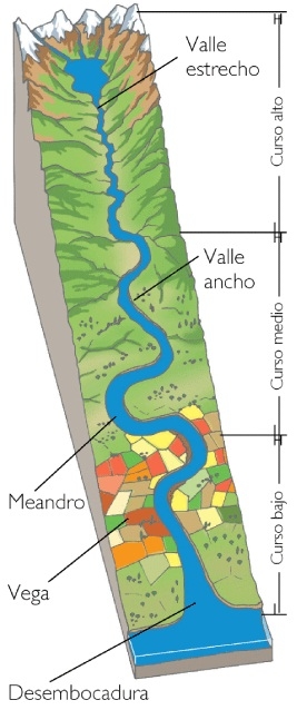
Parts of a river
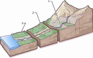
Each river has three parts:
- High course: it is the first part of the river, normally in the mountains. The water descends forcefully. The erosion is very strong.
- Middle course: the slope is smaller. The waters descend more slowly, carrying the eroded materials. The river can form meanders adapting itself to the obstacles.
- Low course: it is the final part where the river finishes its trip. It usually ends in the sea, sedimenting the materials which have been dragged.
The river's mouth can be of two types:
- Delta: land formed by the material accumulated by the river into contact with the sea.
- Estuary: the place where the river comes into contact with the sea, where sea water enters into the mouth of the river. It is submitted to strong tides.
Manzanares river
It is a river in central Spain, which flows from the Sierra de Guadarrama, passes through Madrid, and eventually empties into the Jarama river.
Course
The river Manzanares has its source near the Navacerrada mountain pass in the Guadarrama mountain range.
The upper river basin is protected as the Parque Regional de la Cuenca Alta del Manzanares, a nature reserve which is recognised as a biosphere reserve by UNESCO.
The Manzanares flows in a south-eastern direction from its source, and passes through Manzanares el Real where it is dammed to form the Santillana reservoir, one of the most important water supplies for the capital.
The river then takes a southern direction and enters the Monte del Pardo, an ecologically valuable area on the edge of Madrid.
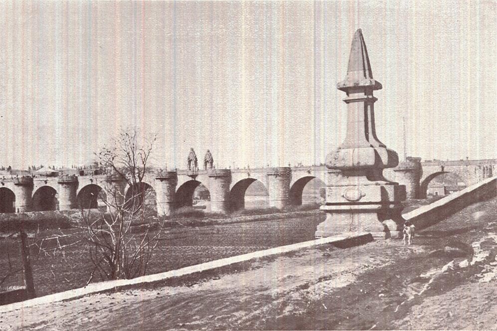
The river is canalised where it passes through the built-up areas of the city.
The Manzanares skims past the westernmost part of the city and further downstream serves as a dividing line between the old centre of the city and the Carabanchel and Usera neighbourhoods to the southwest.
It is along this stretch that it passes next to Atlético Madrid's football ground, the Vicente Calderón.
The river leaves the city at its southernmost tip, it makes a strong eastern turn which takes it past the village of Perales del Río and towards the river Jarama, into which it flows near the town of Arganda del Rey, ending its 83 km (51 mile) journey.
Historical importance
The river Manzanares, although small and relatively unimportant geographically, has had a great historical importance due to its close relation to the city of Madrid. The city was founded by the Moors as a citadel overlooking the river in the ninth century.
The Manzanares was also an important defence line for the Republican forces during the Siege of Madrid in the Spanish Civil War.
The Cache
To log this cache:
Send us an e-mail with the answer to this question: what happen with the eroded materials in this part of the river? Are they torn, transported or sedimented
Answer the folowing question: Around the coordinates there are four street lamps. Near the top of each one, there are some numbers in white. Please let us know the numbers.
Optional: Load a photo of yourself with your GPS at the coordinates.
English version above
Un río es un curso natural de agua, que fluye hacia un océano, lago, mar u otro río. En algunos casos, un río simplemente fluye hacia el interior de la tierra o se puede llegar a secar completamente antes de alcanzar otro mar, río, etc.
Un río es parte del ciclo hidrológico. El agua que lleva, generalmente proviene de precipitaciones, acuíferos, manantiales, deshielo anual y de grandes superficies heladas como los glaciares. Potamología es el estudio científico de los ríos.
Partes de un río
Cada río tiene tres partes:
- Curso Alto: es su primera parte, se encuentra normalmente en las montañas. El agua desciende con fuerza por su superficie, con lo que el efecto erosivo es muy alto.
- Curso Medio: el grado de inclinación es menor. El agua desciende mas lentamente, llevando materiales de erosión. El río puede formar meandros adaptándose de esta forma a los obstáculos.
- Curso Bajo: es donde el río termina su viaje, normalmente en el mar, donde sedimenta los materiales que ha ido dragando.
La desembocadura del río puede ser de dos tipos:
- Delta: tierra formada por los materiales acumulados por el río, cuando entra en contacto con el mar.
- Estuario: lugar donde el río entra en contacto con el mar; donde el agua de mar entra en la boca del río. En esta zona se dan fuertes mareas.
El río Manzanares
Es un río que se encuentra en la zona central de España, que fluye desde la Sierra de Guadarrama, atraviesa Madrid y termina en el río Jarama.
Curso
El Manzanares nace cerca de Navacerrada, montaña que pertenece a la Sierra de Guadarrama.
El curso alto del río es una zona protegida, al pertenecer al Parque Regional de la Cuenca Alta del Manzanares, una reserva natural que está reconocida como reserva de la biosfera por la UNESCO.
El Manzanares fluye en dirección sureste durante su curso, atravesando Manzanares el Real, donde se apresa en el embalse de Santillana, una de las más importantes reservas de agua para la capital.
Entonces el río toma dirección sur entrando en el Monte del Pardo, un área de gran valor ecológico en las cercanías de Madrid.
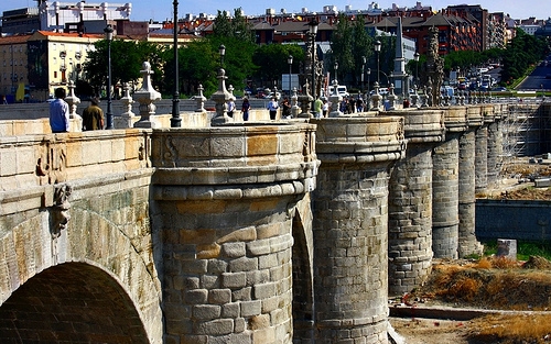
El río está canalizado al pasar por las áreas urbanizadas de la capital.
Toca ligeramente la parte mas occidental de la ciudad y mas abajo en su curso sirve como línea divisoria entre la parte antigua de la ciudad y los barrios de Carabanchel y Usera, que se encuentran en el suroeste.
En este estrechamiento pasa cerca del campo de futbol del Atlético de Madrid, Vicente Calderón.
El río deja la capital por su área situada mas al sur, realiza una gran curva hacia el este que le lleva a pasar por el pueblo de Perales del Río y fluye hacia el río Jarama cerca del pueblo de Arganda, donde termina su viaje de 83 kilómetros.
Importancia Histórica
El río Manzanares, aunque pequeño y geográficamente poco importante, ha tenido una gran importancia histórica debido a su relación con la ciudad de Madrid. La ciudad fue fundada por los árabes como ciudadela sobre río en el siglo noveno.
El río fue también una línea defensiva importante para las fuerzas republicanas durante el asedio a la ciudad de Madrid durante la Guerra Civil española.
El Caché
Para registrar este caché como encontrado es necesario:
Envíanos un correo con la respuesta a la siguiente pregunta: Qué crees que ocurre con los sedimentos en este curso del río, ¿son arrancados, transportados o depositados?
Responde también a la siguiente pregunta: Alrededor de las coordenadas hay cuatro farolas, y cada una de ellas tiene un número pintado en blanco en su parte superior. ¿Cuáles son esos números?
Opcional: Sube una fotografía tuya en el lugar de las coordenadas, con el GPSr en la mano.