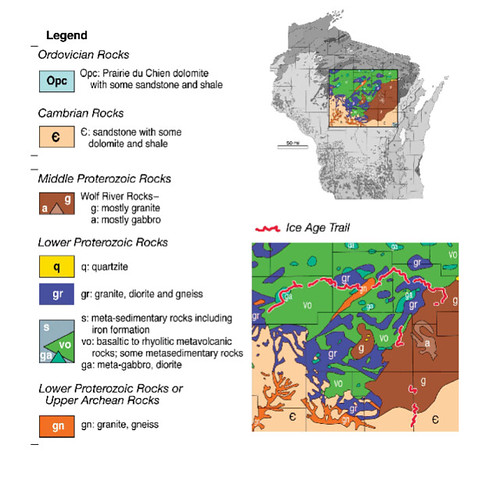
A boulder train consists of a line or fan-shaped spread of glacial boulders derived from one locality. At this location, the boulders are primarily from the Wolf River batholith. A batholith is a large mass of igneous rock that was once molten material that solidified below the Earth’s surface. Batholiths are usually granite with steeply inclined walls and no visible floors. They can be many miles in diameter. The extent of the Wolf River batholith is ill-defined, but it extends from Waupaca on the south to Lakewood on the north; from Wausau on the west to Shawano in the east.
©2011 by the Board of Regents of the University of Wisconsin System, Reprinted by permission of the University of Wisconsin Press.
The Wolf River batholith was created 1,450 million years ago beneath present-day central Wisconsin. It is similar in age to other granites in southeastern Missouri and the southwestern United States. Taken together, this indicates there was widespread tectonic and/or volcanic activity that existed throughout the southern part of the North American continent 1,400 to 1,500 million years ago.
The Wolf River batholith contains large grains of feldspar which is a common mineral in Earth’s crust. Batholiths usually have joints or cracks which break the rock apart when water penetrates and weathering takes place. Large boulders of this granite were picked up and carried a short distance and left behind by the glacier. The directional orientation of the boulder train shows the directional orientation that the glacier moved. These boulders can be found along the trail in the western Green Bay lobe and the northern Langlade lobe. Almost all of the rock is granite with an orange or pink cast because of the iron released by weathering.
 IATCC is the cache designation to highlight a series of EarthCaches along the Ice Age National Scenic Trail grouped into a special category called "ColdCache."
The Ice Age Trail is one of eleven National Scenic Trails designated by the National Park Service. This unique trail is entirely within the state of Wisconsin and follows along the terminal moraine of the most recent glacier which retreated about 10,000 years ago.
This project is supported by the Ice Age Trail Alliance (IATA). The goal is to bring more visitors to the trail and promote public awareness, appreciation, and understanding of Wisconsin’s glacial landscape.
The IATA has created an awards program to encourage visits to the trail and ColdCache sites. This awards program is separate from, and in addition to, any other Geo- or EarthCache awards program.
A current list of approved ColdCache sites can be found on the “IATCC Bookmark List”. More information on the Ice Age Trail Atlas, the Companion Guide, the ColdCache Project and Awards Program can be found on the “ColdCache Webpage”
The Geocache Notification Form has been submitted to Dawn Bishop of the Wisconsin DNR. Geocaches placed on Wisconsin Department of Natural Resource managed lands require permission by means of a notification form. Please print out a paper copy of the notification form, fill in all required information, then submit it to the land manager. The DNR Notification form and land manager information can be obtained at: www.wi-geocaching.com/hiding
Resources:
Answers.com
Geology and Age of the Wolf River Batholith, Wisconsin; Geologic Society of American Bulletin
Geology of the Ice Age National Scenic Trail; by David M. Mickelson, Louis J. Mahler Jr., and Susan L. Simpson
Roadside Geology of Wisconsin; by Robert H. Dott, Jr and John W. Attig
Wikipedia
1. What is the directional orientation of the boulder train? Based on this information, what direction did the glacier move at this location?
2. Look closely at some of the rocks. Do the rocks look like they are primarily the same type of rock?