SEA STACK DEFINITION: A sea stack is an isolated pinnacle of rock entirely surrounded by the sea at high tide.
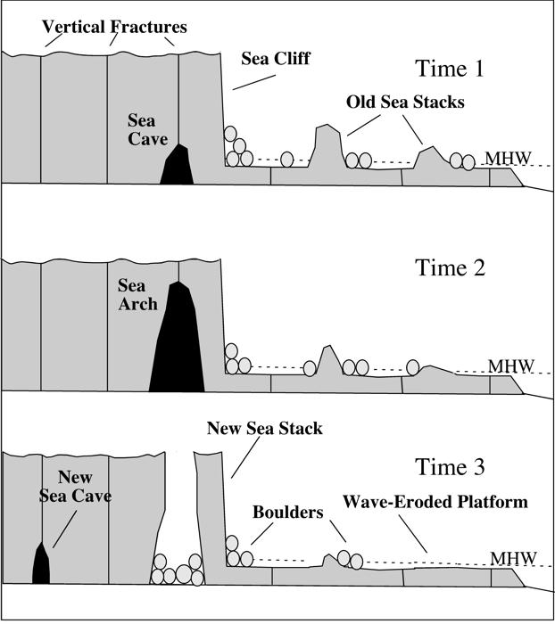
SEA STACK FORMATION: Sea cliffs around our coast receive a constant onslaught of erosional processes. The most important is Hydraulic Wave Action, which in simple terms is the process of waves hitting the rocks at incredible pressures and literally `exploding` in the joints and crevasses. Softer rock is exploited at a faster rate than harder rock and eventually the cliff will fall away unevenly to form headlands and bays.
Waves will continue to batter the headlands from both sides and in softer rock a sea cave will form with a single opening. The opening will continue to be exploited until the cave opens all the way through to form an arch.
Even with the formation of the arch the erosional processes do not stop. The waves continue to widen the gap until the rock above can no longer be supported. At this point the top portion collapses into the sea below. This leaves the furthest arch support standing out in the open sea as a SEA STACK.
If its summit has a larger diameter than its height, then it is an island.
The actual geology of the Lizard area is very complicated but to keep things simple Bumble Rock is made of `Hornblende Schist`.
SCHIST DEFINITION: This is a metamorphic rock which is defined as "Any of a class of rock that result from the alteration of pre-existing rocks in response to changing geological conditions, including variations in temperature, pressure, and mechanical stress". Basically, it was originally another type of rock that has been changed over many thousands of years and in our case become SCHIST which has a `flaky` type structure. It looks a bit like slate with lots of small horizontal layers! This means that they can split and therefore erode very easily when subjected to some kind of force. In our case `Hydraulic Wave Action`. Don`t forget that there will be lots of smaller bits of rock fragments thrown around in that huge `washing machine` called the Atlantic Ocean. `Every little bit helps` to smash the coast to pieces!
Not all rock types are even in their hardness and so the coast at the Lizard is very `jagged` due to different areas being worn away at faster rates than others. It just so happens that we have a slightly harder structure in Bumble Rock and hence a sea stack could form.
Bumble Rock is an excellent example of a Sea Stack found on the British coastline and if you go there on a stormy day and high tide you will experience the waves crashing over and exploding onto it. You will experience the power of the sea and just how it`s mighty force of water pressure actually erodes even the hardest of rocks.
PLEASE NOTE: I CANNOT ACCEPT JOINT ANSWERS FROM GROUPS OF GEOCACHERS NOR JOINT PHOTOS AS I DON'T HAVE THE TIME TO SORT OUT WHO HAS SENT WHAT FOR WHOM!. IF YOU WANT TO LOG MY EARTHCACHE PLEASE EXTEND ME THE COURTESY OF MESSENGING ME YOUR OWN ANSWERS INDIVIDUALLY AND ADD A PHOTO TO YOUR OWN LOG. THANK YOU
To log your visit to the Earthcache you must complete a task:
1. Optional - please take a photo of Bumble Rock with your GPSr in the foreground and upload it to your log. If you would like to be in the photo yourself that would be great.
2. Message me (via the link at the top of this page) the answers to the following questions. Do not put them on the `logged it` page. Metric or Imperial is acceptable.
a. Estimate the height of Bumble Rock.
b. Estimate the width of Bumble Rock at the base and top.
c. Estimate the distance from Bumble Rock to the main headland (which you are standing on), not the adjacent island.
WARNING: DO NOT be tempted to climb down the cliff as they are very dangerous. Keep away from all cliff edges and remain on the Public Footpath at all times.
ALL DOGS MUST BE KEPT ON A LEAD and CHILDREN MUST BE SUPERVISED AT ALL TIMES. THIS IS A DANGEROUS LOCATION. You have been warned!
Limited free parking for the Earthcache can be found at Lizard Point. More extensive pay parking is located at the NT car park just behind Lizard Lighthouse.
YOU MUST LOG AT THE SAME TIME AS SENDING ME YOUR ANSWERS VIA A GEOCACHING MESSAGE. If you can`t do both at the same time then wait until you can, otherwise I will just delete your LOG and you will have to do it all again as I DO NOT have the time to chase after you. AND be warned, I do check every one! Unfortunately, a few geocacher`s try to log the earthcache without completing the task and so I will maintain the right as the earthcache owner to delete any logs that do not fulfill the requirements or I entries that I believe to be false. I will ONLY contact you if there is a problem AND I will delete any logs for which I don`t receive answers or LOGS that I believe to be false.
This is No 7 in Snake Plissken`s Lizard Peninsula Earthcache Series!
SNAKE PLISSKEN -