Mill Road in Bromborough is home to a ‘Horst and Graben’ Fault Line. This means that tensional forces have pulled the rocks apart meaning the graben (middle section) has dropped downwards. Horst and Graben; elongate fault blocks of the Earth’s crust that have been raised and lowered, respectively, relative to their surrounding areas as a direct effect of faulting. Horsts and grabens may range in size from blocks a few centimetres wide to tens of kilometres wide; the vertical movement may be up to several thousand feet. They are bounded on both sides by steeply dipping normal faults, along which movement has been essentially equal, resulting in blocks that are scarcely tilted. The faults forming horsts generally dip away from each other: those forming grabens generally dip toward each other. Two or more horsts and grabens may occur adjacently. They are thought to be due to lateral tension possibly produced by regional uplift or salt dome formation; they often occur on the crests of domes or anticlines. Valleys formed in grabens are commonly called rift valleys and may exhibit features of vulcanism often associated with graben formation. Examples of grabens are the Jordan Dead Sea depression and Death Valley. The Vosges Mountains of France and the Palestine Plateau are typical horsts.
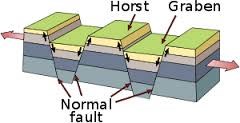
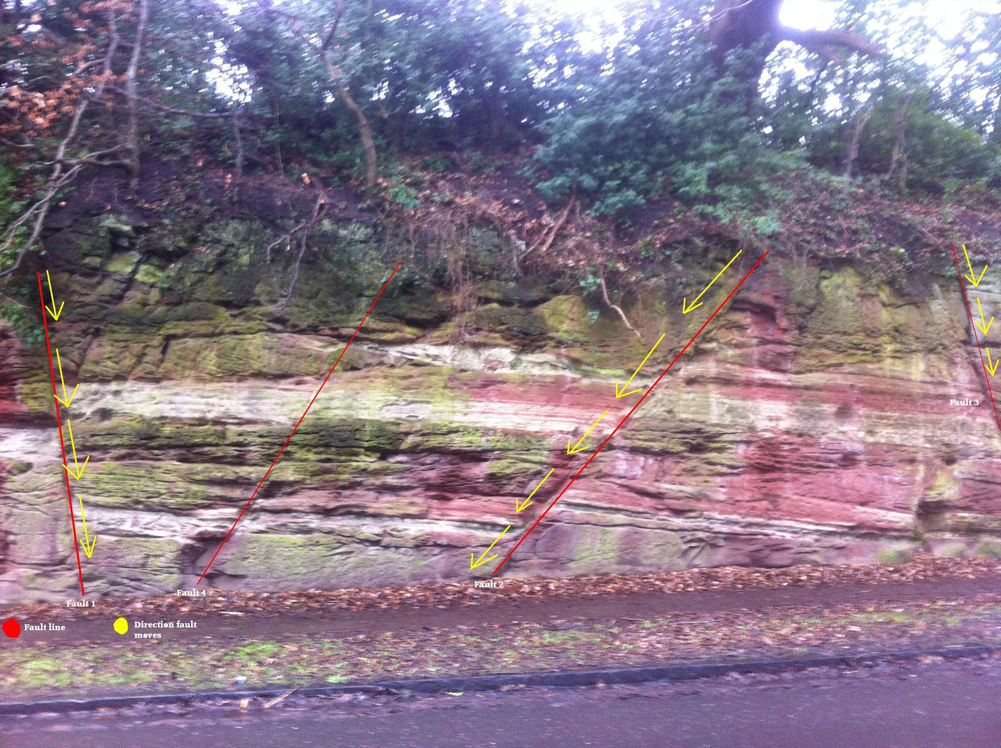
Horst and Graben are formed when normal fault of opposite dip occur in pair with parallel strike lines. Horst and Graben are always formed together. Graben are usually represented by low-lying areas such as rifts and river valleys whereas horsts represent the ridges standing between/on either side of these valleys. At the above co-ordinates, the main feature is the cliff face, as shown in the picture below. The faults have shifted down as a result of the tensional forces meaning the Graben (middle section) had dropped downwards.
To claim a find on this Horst and Graben fault EarthCache, we would like you to:
1) How many types of layer are there in the cliff face?
2) Compare the textures of the two types of layer, also explore their grain size and colour
3) What is the throw (distance moved) of Faults 1 and 2, labelled on the diagram? Also, what is the downthrow side (how far they have sunk)?
4) Again looking at Faults 1 and 2, estimate the angle of the faults
5) Optionally, take a picture of yourself and /or your GPS at the posted co-ordinates.
Please do not post the answers to these questions in your log, even if encrypted - send them to me via my profile. We hope you enjoy this EarthCache.