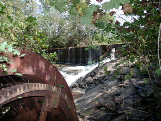
This water wheel is not as accessable as the first, and a little smaller, but equally interesting. The wheel has a large gear around its circumference, which apparently ran a smaller wheel to step up the speed and transmit power up to the mill. I'll post more as I learn more.
In studying the construction of the wheel there are signs that it was disassembled after construction, then reassembled on site. The gear segments are marked with punch marks to ensure that it's put together correctly: the end with five marks matches up with five marks on the adjoining segment, and so on. It appears that the wheel originally spun on brass or bronze bushings, with only one lower bearing shell remaining. If my count is correct there were originally 32 thin steel blades around the outside of the wheel impacted by the rushing water, but only one is still there. The rest have been pulled off or rusted away.
There's a cool dam and millpond upstream from the wheel, with an opening for the pipe that originally routed water to the wheel. The rocks below the dam can be slippery if they're wet, so be very careful.
If you look at the cache location using MapQuest or MapPoint you'll wonder if I've gone off the deep end. Don't freak out! If you use the older TopoZone map you'll see the original mill pond just south of the cache with a bridge over that millpond.
To get to the cache don't park near the old bridge visible from the expressway on - ramp. This is dangerous and illegal. There is a sign there that says to keep moving. Don't pull off there and park on the grass. It's also pretty marshy near that old bridge, so you'll regret going that way if you do.
Instead you can park behind the hotel at N34° 03.530 / W83° 59.753, walk across the empty lot, and down the embankment. Please make your own path down the hill rather than following an existing one to prevent eventual erosion damage. Or you can park at Michael's at N34° 03.672 / W83° 59.717, cross the bridge, then go down the embankment there. Either way the embankment is steep (be careful) and you'll intercept an old road bed that parallels the creek and will take you to the cache. You'll be walking far under the expressway ramps as you follow Ivy Creek. The cache is a .50 cal ammo can buried among rocks. Please cover it back up well.
If you want a quick look at your target as you drive by take the Hwy 20 East exit off I85 South and look carefully as you go around the loop. It's strange how such a neat spot was marooned in the name of progress, but luckily it can be reached safely if you know how.
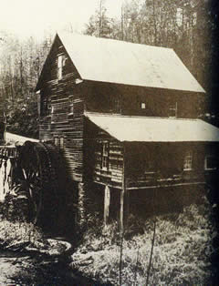
Geocacher Alan Rees / Leapgorf contributed the old map and photos of Woodward's Mill you can view by clicking on the attachments below. Thanks Alan!
Kenneth Pruett found the little photo below on the GwinnettForum.com web site. Thanks Ken!
Update 3/17/07: Judging from the lunch trash I picked up the workers had been sitting around the cache and discovered it. I've moved it to a more secure location. It is now in a small lock&lock container. It appears that a paved trail is being constructed to connect to the existing trail that runs behind the nearby apartments. For your safety and that of the cache please only hunt it on weekends when there are no workers present. There is no signage present indicating that this area is restricted in any manner, so I would assume the cache is as welcome as in any other public area.
Update 7/15/07. Checked on cache today. It's fine. The "Ivy Creek Greenway" is coming along nicely. You can access this cache by walking a mile from "mog's cache" on a nice level trail. Park at N 34° 03.715 W 083° 58.977 to do that. I am concerned about it's continued viability at this location though, as it's now between two pairs of benches on what will soon become a busy path. If it disappears again I'll have to move it into the woods away from the water wheel.
Update 10/29/09: High waters washed the cache away. A new one is back in the same place, but under a heavy rock. Please be gentle so as to not damage the lock & lock container with the rock.
Update: 3/3/10 High waters (or muggles) required replacing the cache yet again. It'll require a bit more clambering to get to it. Please be sure to cover it with rocks.
Please be wary of yellow-jackets building next under the rocks on the hillside. The cache is much closer to the water, but I've been stung, don't want you to.
Update 4/12/14 Replaced cache yet again. Same spot as before.
Be careful of yellow-jackets building nests in the rocks on the hillside. If they are active return after the first frost kills them off.
Update 5/21/17. Replaced cache again. Hidden higher up on the bank this time.
Update 8/7/20. Replaced cache yet again. Must be the sixth one...