|
This Earthcache is a hike up a cinder cone in the San
Francisco Volcanic Field.
This 2.4 mile roundtrip hike starts out on
a wide, well graded path through the pines. The initial climb is
gradual until you come to the switchbacks. The trail then turns
into single track and starts to get steep. When you reach a "T"
intersection on the east side of the crater near the saddle, turn
right to go to the caves. Heading left will take you to a higher
peak of the crater.
The views of the
surrounding area are amazing and well worth the hike. The elevation
gain is 430 feet and the summit sits at 7,183 feet, if you are
visiting from lower elevations you are in for a bit of
exertion.
These caves used
to be one of Flagstaff's best kept secret. Around 2004 the National
Forest Service built a trail and parking area and now the site is
better known. I say this with a little cynicism because the 800
year old Sinagua potsherds that used to be scattered about the peak
are dwindling. PLEASE don't take these home with you, once they are
gone they are gone for good and we would like the generations ahead
of us to be able to enjoy this area as much as we do
now.
Notice the area
directly around the pit caves, there is an abundance of igneous
rock in piles. These were once rooms of the village that sat here.
The pits are naturally formed by lava with the exception of some of
the passageways that had been carved out by the Sinagua.
Archaeologists believe these caves were probably used for storage
and that the area was occupied around 1250 to 1300
A.D.
The volcano
holds some geological mysteries too. Instead of the usual cinder
cone with lava at its base, Old Caves Crater has its lava on the
summit ridge. Furthermore the lava formed room-like chambers called
"bubbles" or vesicles. The Sinagua built their village above the
bubbles, using them as rooms, then carved out storage alcoves and
connecting passageways. The pueblo walls, built of unmortared
stone, have largely fallen down, but you can see the underground
chambers and sherds of the Sinagua's plain pottery. Archaeologists
found burials just below the pueblo and a ball court at the base of
the volcano. Visitors must take care not to disturb the pueblo or
remove anything from it.
A little
education about Cinder cones.
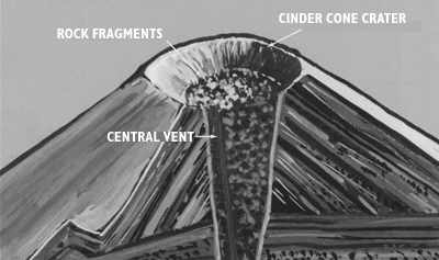
Cinder
Cones are among the simplest
volcano
formations in the world. They are built by
fragments (called ejecta) thrown up (ejected) from a
volcanic vent, piling up around the vent in the shape of a
cone with a central crater. Volcanic cones are of
different types, depending upon the nature and size of the
fragments ejected during the eruption. Types typically
differentiated are spatter cone, cinder cone, ash
cone, and tuff cone.

You are standing
in one of the most volcanic regions in North America. The San
Francisco Volcanic Field covers 1,800 square miles (4,700
km2) and is the southern boundary of the Colorado
Plateau. The area contains 600 volcanoes which range in age from 6
million years old to 1000 years old.

Directions:

To get there head north 5.5 miles on US 89 from I-40 Exit 201 to
Silver Saddle Road, which has a traffic light between Mileposts 422
and 423, then turn right half a mile on to the signed trailhead,
which will be on your left @ N35 16.199 W111 32.125. Follow signs
up to a trail junction on the summit ridge, then turn right to the
pueblo. Take the other fork on the summit ridge to reach the
highest point and a panorama of volcanoes to the north. The
moderate hike is 1.2 miles one way with a 430-foot elevation gain
to the pueblo, then another 100 feet to the 7,183-foot
summit.
Some of these
bubbles were frozen in the lava in what are called vesicles. Most
of the vesicles are small, but sometimes, the gas accumulates under
outer surface of the flow that has cooled forming large
vesicles.
These large
vesicles are what has formed the caves on the top of this cinder
cone.
To log this
EarthCache:
To receive credit
for this Earthcache you must send me a separate email with the
answer to these questions. In the email please post the title of
the Earthcache you will be logging. Please do not post the answers
here.
How does the
ground you are walking through change as you head up this Cinder
Cone?
How many caves
are there?
Estimate how
many cubic feet the largest cave is?
Posting pictures
is always welcome as well.
Please practice
leave no trace guidelines while searching for this Earthcache. They
are listed below.
Leave
No Trace Techniques for
Earthcaching
The essentials of responsible
geocaching:
-
Never bury caches.
-
Never leave food items in a cache.
-
Replace rocks & other natural objects lifted during a
search.
-
Find routes that minimize impact.
-
Leave places looking as if the seekers had never been
there.
-
Leave all Archeological remains as you found them for future
visitors to enjoy.
Enjoy this Earthcache and have fun.
To
find more Earthcaches in your area follow the link
below.

|