|
Please Note: The park is open from dawn 'til dusk. The park is also closed at peak geocaching times such as New Years Day, Presidents Day, Easter, Thanksgiving, Friday after Thanksgiving, Christmas Eve, and Christmas. So plan your caching accordingly!
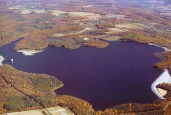
Merrill Creek Reservoir is located on top of Scotts Mountain, also known as Montana Mountain, in Harmony. Merrill Creek Reservoir is a 650-acre reservoir surrounded by a 290-acre Environmental Preserve and 2000 additional acres of woods and fields. Its basic purpose is to provide stored water that can be released to the Delaware River to make up for the evaporative water usage at certain electric generating units in times of low flow in the river. In addition to that basic purpose, Merrill Creek Reservoir provides a tranquil setting of water and land that allows people to interact with the natural environment.
Trail Information:
Length: 4.5 miles around the 650 acre reservoir
A pristine scene along the shores of Merrill Creek Reservoir is punctuated by a pair of nesting eagles perched high in the tree tops. Bring binoculars along for spotting distant wildlife such as birds, deer, squirrels, chipmunks, or occasional bears. Various trails link the Visitor Center to the circumference trail that loops around the reservoir. Traveling counterclockwise around the reservoir, you will first hike through the trail complex until you finally cross Merrill Creek, the namesake of the entire reservoir. Now you are out of the trail complex and on the loop trail.
The trail skirts the reservoir's northern shoreline, passing dozens of bare, skeletal "drowned trees", great shelter for fish. Ospreys, and even eagles, perch on the dead trees, surveying the reservoir for fish.
The trail emerges from the woods and passes over the top of the first of three dikes blasted out of the bedrock during the construction of reservoir. After walking a short distance, the trail crosses a large flat "field", constructed to be the spillway for the reservoir. Many nice wildflowers and butterflies may be seen here during the warm seasons. As you cross this area, look back and you will see the Delaware Water Gap to the north and Wind Gap to the northwest.
The trail turns left at the end of the spillway and crosses the parking lot for the inlet/outlet tower, one of the best vantage places on the reservoir, offering tranquil panoramic views of the reservoir and the Delaware Valley below. This is where bird watchers gather to watch the fall hawk migration, and eagles year round. In the winter, this is a great place to observe the various species of ducks that gather in open, unfrozen sections of water. Some years, many thousands of Canada geese and Snow geese gather here, offering spectacular views as the huge flocks take off, circle overhead, and then land again.
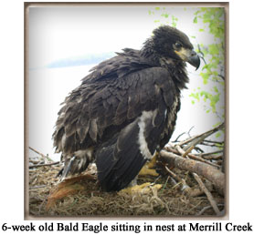
From the parking lot, the trail crosses the second dike, entering the woods at the other end. A trail merges from the left, coming up from the reservoir shoreline and leading to an observation platform along the shoreline from which the first eagle's nest can be seen. The reservoir hosts a pair of resident bald eagles. Over the past few years they have raised at least 6 young eagles and have had nests at two different locations, the latest nest being in plain view from the inlet/outlet parking lot.
The circumference trail emerges from the woods, leading down to the top of the main dam. After crossing the dam, the trail leads through more woods, some open shoreline, and the southeast dike. After a short walk, the trail leads to the parking lot for the boat ramp. Across the parking lot, the trail leads upward a short distance then back to the visitor center where it started.
Make sure to bring binoculars along on the hike. On the land, they will be helpful in spotting distant wildlife such as deer, squirrels, chipmunks, or even occasional bears. Along the shore or over the reservoir, binoculars help to see ospreys and eagles as they search for fish, various gulls, ducks, loons, grebes, and other birds. The types of birds seen here will vary with the season, although the eagles are here year round. Some of the rare or unusual birds seen here are snowy owl, pacific loon, sabine's gull, redhead duck, barrows golden eye, crossbills, pine grosbeak, bald and golden eagle, goshawk, cliff swallow, red necked grebe, rough legged hawk, peregrine falcon.
|
|
Eagles
Merrill Creek Reservoir's resident bald eagles have begun their eleventh nesting season in 2009.
The story of the Reservoir's nesting bald eagles began in the fall of 1997. Bald eagles are usually spotted gliding over our hawk watch during the fall. They are occasionally joined by golden eagles also passing through on their migratory journey.
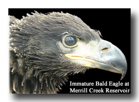
What was different about this pair of adult bald eagles was that they decided to hang around. Instead of using Merrill Creek as a pit stop to rest and refuel on some fish or waterfowl, they settled in. During the spring and summer of 1998, our optimism grew that they may indeed nest. Along the western shore of the reservoir, the eagles constructed three crude "house-keeping" nests. A biologist from the New Jersey Endangered and Non-game Species Program explained that these practice nests were almost always observed the year before a pair of bald eagles mate and establishes a real nest.
In the winter of 1999 continued observation of the eagles revealed that Merrill Creek would become only the second nesting location for bald eagles in the Northern half of the state!
The Merrill Creek Naturalists, Jane Bullis and Jim Mershon, have kept a close eye on the eagles ever since. Using a spotting scope and observing from across the reservoir at the I/O Tower parking lot, they are able to track the eagles nesting cycle without disturbing them.
| Activity Observed |
| 3/31/09 |
Female confirmed incubating (latest date recorded for MCR pair) |
| |
Confirmed hatch date. |
Have you seen Eagle Activity? Please share it with Merrill Creek Reservoir!
E-Mail: Jane Bullis or Jim Mershon
Please remember that these birds are very sensitive to human disturbance! Do not attempt to walk or boat within 300 yards of the eagle nesting area. The best observation point is from the Inlet/Outlet Tower parking lot.
To reach this area, park at the parking lot off of Fox Farm Road.
|