Geologic Highlights: Recessional cataract canyons, plunge
pools, flood bars, ancient dry lake beds; adjacent flood-swept,
upland plateau covered with potholes and giant grooves. Eroded
contact between ancient 50 to 100 million-year-old granite beneath
15-million-year-old Columbia River basalt.
Cache Elevation: 2,280 ft
Directions to trailhead: From SR 155, directly across
from Steamboat Rock, turn east onto Northrup Rd. Pass eddy flood
bar at mouth of canyon and ascend 0.6 mi to parking area and rest
room at end of gravel road ("P" in Figure 1). From the trailhead
it's a little over seven miles to the Earthcache and back.

Figure 1. Northrup Canyon area map. A tall
ridge of granite runs down the middle of the canyon. At one time
the granite was completely buried under basaltic lava flows but
later exhumed by Ice Age floods. Block arrows indicate flood-flow
directions.
Northrup Canyon is an idyllic, open-forested
canyon where cataclysmic Ice Age floods once ate through a pile of
layered basalt flows into granitic basement rock as they spilled
over a side canyon into Grand Coulee (Figures 1 and 2). The steep
walls of the multi-armed canyon tower up to 400 ft or more.
Megafloods eroded through the basalt bedrock exhuming a once-buried
ridge of granitic basement rock (50-100 million years old) that
parallels the canyon. Long ago (15-16 million years ago), during
the Miocene Epoch, basalt flows lapped up onto and around the
eroded granite ridge eventually burying it in lava. Since that time
the Ice Age floods eroded through the basalt cover locally exposing
the granite rock below. Successive floods exhumed the ridge by
taking advantage of the weaker, weathered rock along the contact
between the two rock units. The last megafloods, derived from
cataclysmic outbursts from glacial Lake Missoula, were about 15,000
years ago.
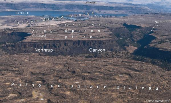
Figure 2. Aerial view of
Northrup Canyon. Everything in this image was overrun by hundreds
of feet of rushing water during the largest megafloods. Adjacent
upland plateaus were also swept clean by the floods, which carved
huge grooves and potholes into the basalt surface. Looking
northwest.
Ice Age floodwaters spilled over
into the Northrup Canyon both: 1) during earlier Ice Age floods
before the Upper Grand Coulee cataract had retreated all the way to
the head of Grand Coulee, and 2) when glacial ice of the Okanogan
Lobe blocked the Upper Grand Coulee. Figure 3 shows how the flow of
floodwater when glacial ice blocked the Upper Grand Coulee, forcing
all the floodwater into Northrup Canyon and across the upland
plateau above Grand Coulee. Northrup Canyon was probably not used
during the last floods after the head of the Grand Coulee was
breached; this event lowered the divide at the head of the canyon
by as much as 900 ft, probably causing all subsequent floods to
flow down Grand Coulee - bypassing Northrup
Canyon.
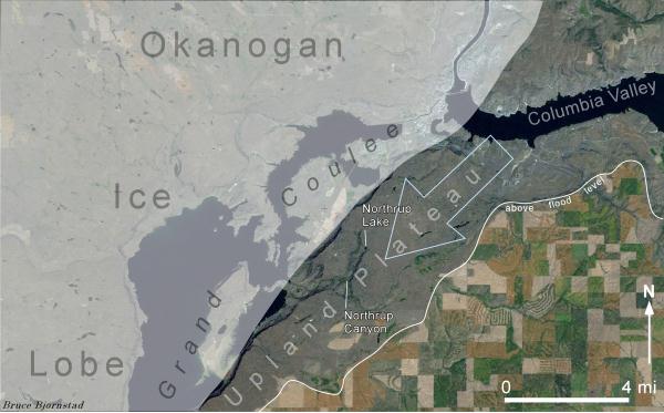
Figure 3. Aerial view showing how floodwaters
(block arrow) spilled over into Northrup Canyon from the Columbia
Valley when Grand Coulee was blocked by the Okanogan Ice Lobe.
Patch-worked farmland in lower right generally escaped erosion by
megafloods. The end result was a flood path that was confined to
the narrow upland plateau that parallels the Upper Grand
Coulee.
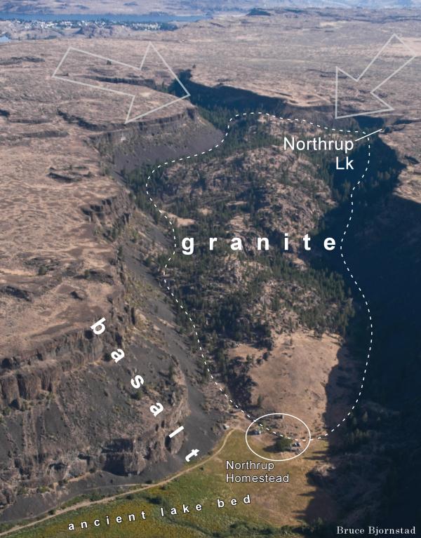
Figure 4. Upper Northrup Canyon. Dashed
outline is area of exposed granite. Block arrows show movement of
Ice Age floodwaters that spilled over from the Columbia Valley to
the north (visible at top of photo).
The trail to the Northrup Lake plungepool passes
the now-abandoned Northrup Homestead (Figure 4). Along the way to
the Homestead is a huge flood bar along the south side of the
canyon and a couple flat-bottomed, now-dry lake beds (Figure 1). At
Northrup Homestead, the canyon bifurcates into two main arms. One
arm trends north terminating on the upland plateau only about ½
mile from the edge of Upper Grand Coulee (Figure 4) – a
second arm branches southeast from the homestead. Both arms are
cataract canyons that receded across the upland plateau during
multiple megafloods. The trail to the Northrup Lake plungepool and
the Earthcache lies at the head of a short side canyon that
branches off the northern arm of Northrup Canyon. The canyon is an
oasis in the eastern Washington desert, which supports the growth
of quaking aspen and Douglas Fir - the only naturally-growing fir
here in Douglas County!
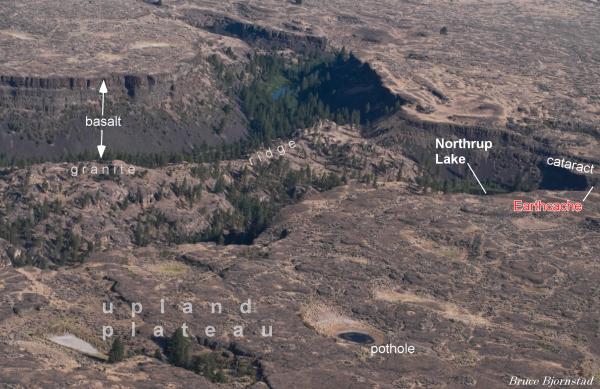
Figure 5. Upper Northrup Canyon, looking
north. A granite ridge, running down the middle of the canyon, was
exhumed during multiple Ice Age floods. The Earthcache lies atop
the cataract cliff above the Northrup Lake
plungepool.
To make the final approach to the Earthcache
continue along south side of Northrup Lake via an old jeep trail
that traverses diagonally up the east side of the cataract. Once
atop of the cataract walk north along the rim of the west-facing
cliff precipice a short ways to the Earthcache. To the north, east,
and south is the flood-swept upland plateau that surrounds all of
Northrup Canyon (Figure 5). To the southwest is a spectacular view
back down the canyon (Figure 6). During the largest megafloods
water rose to near 2,500 ft elevation, about 200 ft higher than the
level of the Earthcache and upland plateau.

Figure 6. Northrup Lake plungepool from
cataract cliff at head of Northrup Canyon. A ridge of more
flood-resistant granite runs up the middle of Northrup Canyon,
dividing it into two lesser subcanyons. Multiple flows of volcanic
basalt cover the upland plateau that surrounds the
canyon.
Recession of the cataract and headward growth of
Northrup Canyon probably occurred in multiple spurts from many
floods. Northrup Lake represents the plungepool that developed as
the floodwaters dropped over the receding cataract for the last
time. During a future Ice Age flood, the cataract will likely
continue its march northeastward toward the Columbia
Valley.
To receive credit for finding this Earthcache
answer the following question: What type of rock is underfoot at
the Earthcache? Is it: 1) massive, light-colored granite, 2)
layered black basalt, or 3) another type of rock?
Email answer to bjorn99352@yahoo.com.