Welcome to the next
edition of Doc.’s Roadside Geology Tour: Jackson
County!
"You're traveling through another dimension. A
dimension not only of sight and sound, but of mind. A journey into
a wondrous land whose boundaries are that of imagination. That's
the sign post up ahead. Your next stop...The Driftless
Zone….”
The above listed coordinates will bring you to a wide spot in the
road which offers a commanding view of one of Mother Nature’s
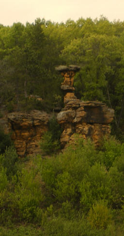
Unique and Fragile Creations ~ Table Rock and it’s little
sidekick, Bear Rock, named for it’s resemblance to a
bear’s head. This rock formation is on private property and
we can only appreciate this from the roadside pull-off.
Many have called this rock formation a “Balanced”
Rock. In actuality it is classified as a Pedestal” Rock ~ a
single piece of stone which has weathered in such a fashion that
its mid-section is narrower than its cap or its base. This
formation is one of the larger and more elegantly formed examples
of a pedestal rock east of the Rocky Mountains.
 Hundreds of millions of years ago an
ancient sea left sedimentation deposits here and all but the most
resistant of these layers were eventually worn away by wind, water
and ice. What you see here today are the last remnants of those
resistant layers.
Hundreds of millions of years ago an
ancient sea left sedimentation deposits here and all but the most
resistant of these layers were eventually worn away by wind, water
and ice. What you see here today are the last remnants of those
resistant layers.
The bluff which stands before you is one of many rocky treasures
spared from the bulldozing effects of the last glacier which
stopped only a few miles away. This formation is what is correctly
known as a mesa (Spanish for "table") as it is a large formation.
Smaller formations are known as buttes and pinnacles. Located in
the "Driftless" (not glaciated) area of Wisconsin, these mesas,
buttes and pinnacles escaped the land scouring activity of nearby
glaciers. It's likely that hundreds or even thousands of similar
formations (which were located outside the Driftless area) were
worn away during the last ice age.
Because the capping material on these bluffs is cemented better
than the under-laying material, erosion by wind and water wears
away the soft sides of these formations until the weight of the
overhanging cap causes it to fall. Frost is also major cause of
erosion and tends to break the formations along joints keeping the
tabletop appearance intact. This formation will continue to
decrease in size until it eventually blends in with the plain on
which it sits; this erosion accelerates once the resistant capping
material has been lost.
To claim credit for this EarthCache, please email to me:
1. Given that the elevation of the top of Table Rock 1135' above
sea level, please take an elevation reading where you are parked
and calculate the height of Table Rock.
2. What is the colour of the rock making up the tabletop? How
thick do you think this layer is?
3. Would you classify this formation as a mesa, pinnacle or
butte?
4. Honestly, do you see the Bear’s Head formation? Where
is it in relation to the Table Rock?
5. Please post a photo of Jackson County’s famous Table
Rock to document your visit to this site.
Buckle up for the next stop on our Roadside Geology Tour of Jackson
County, WI!