This Earthcache is located north of Henderson at a roadside park on State Highway 64.
GEOLOGY OF THE EAST TEXAS OIL FIELD
The East Texas Oil Field is a large oil and gas field in east Texas. Covering 140,000 acres (570 km2) and parts of five counties, and having 30,340 historic and active oil wells, it is the largest oil field in the United States outside of Alaska, both in extent and in total volume of oil recovered since its discovery in 1930. It is a component of the Mid-Continent Oil Province, the huge region of petroleum deposits extending from Kansas to New Mexico to the Gulf of Mexico.
The field includes parts of Gregg, western Rusk, southern Upshure, southeastern Smith, and northeastern Cherokee counties in the northeastern part of the state. Overall the field is about 45 miles (72 km) long on the north-south axis, and five miles (8 km) across. Interstate 20 cuts across the field from east to west, and the towns of Kilgore, Overton, and Gladewater are on the field. At one time, downtown Kilgore had more than 1,000 active wells clustered in a tight area, making it the densest oil development in the world.
The primary productive geologic unit is the Cretaceous-age Woodbine Formation, a regional petroleum-bearing unit which had been known since the early part of the 20th century. This sandstone unit was deposited during a period when East Texas was a shallow sea, approximately 100 million years ago. During a subsequent period it was uplifted, eroded, and then covered again by the sea, which this time deposited a layer of impermeable chalk, creating a stratigraphic trap – a situation where oil, which is lighter than water and migrates upwards, reaches a point where it can move no farther, and pools. The source rock for the oil in East Texas is the lower-lying Eagle Ford Shale. Water intrusion from deeper in Woodbine Formation is the mechanism pushing oil through the reservoir toward the producing wells. A 1932 study showed that oil wells stopped flowing when water pressure dropped below 800 pounds per square inch.
HISTORY OF THE EAST TEXAS OIL FIIELD
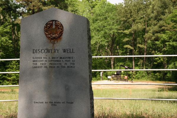
The easy-going rural life of East Texas changed drastically with the discovery of oil in 1930 and 1931 – years of hardship, scorn, luck and wealth which brought people, ideas, institutions and national attention to East Texas. In 1929, a 70-year-old wildcatter, Columbus Marion “Dad” Joiner, unsuccessfully drilled two dry holes south of Kilgore. Then in May, Joiner spudded a third hole on the Daisy Bradford farm in Rusk County. It was not until Oct. 3, 1930 that a production test was done, resulting in a gusher – the discovery well, Daisy Bradford No. 3.
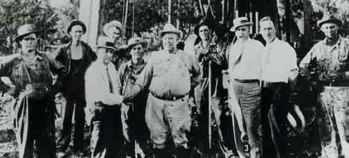
Dad Joiner is the figure in the center of the above picture
Two months later, oil fever had begun to mount with a production test by Bateman Oil Company on the Crim family farm, south of Kilgore. On Sunday morning, Dec. 27, while Mrs. Crim was attending church, the Lou Della Crim well blew in, flowing at 22,000 barrels a day. The well was only nine miles from Daisy Bradford No. 3, yet no one was aware that the two wells were part of what was then a geological phenomenon – an incredible deposit of oil in the Woodbine formation had “pinched out” as it tilted upward against the Sabine Uplift creating the massive East Texas Oil Field.
The initial “oil boom” was completed Jan. 26, 1931 when the J.K. Lathrop lease in Gregg County came in at 3,587 feet, producing 18,000 barrels daily. The Lathrop well was situated on land assembled by B.A. Skipper of Longview and taken over by the Arkansas Fuel Oil Company. Production of East Texas’ newest commodity increased rapidly from seven wells every other week, to seven wells daily, to more than 100 wells put into production each day. The first oil discovered sold for $1.10 a barrel, but prices plummeted to 15 cents as supply flooded the market and drilling activity spread to Upshur, Smith and Cherokee counties. Production swelled to more than 1,000,000 barrels daily and in August 1931, National Guardsmen were ordered into the area to keep peace between roughnecks, lease hounds, oil speculators and camp followers. These actions finally culminated in legislative action – a market-demand law, confiscation law, truck-tender law, the refinery control and felony bill, and the Connolly Hot Oil Act of 1935, which restored order and stability.
The East Texas Oil Field has produced more than 4.5 billion barrels of oil. Some of that gave the Allies the petroleum-reserve stability needed to win World War II. The resulting wealth produced new towns, new ways of living and a livelihood for thousands of East Texas citizens. And the wells are still pumping......
 To get credit for this earthcache, please email the anwers to the following questions to the cache owner:
Question 1. The East Texas Oil Field produces from the Cretaceous-age Woodbine Formation, which is composed of sandstone at a depth of approximately 3,500 feet below the surface. Look at the dirt and rock at the listed coordinates. Does the surface soil consist of oil bearing sandstone or is it primarily clay?
Question 2. There are two historical markers here. One is about the Daisy Bradford #3. According to this marker, how many gallons of oil have been extracted from the East Texas Oil Field (42 gallons equals one barrel)? Based on the current oil price range of $80/bbl, what would the value of that be today?
Question 3. What is the title of the other historical marker that was put there via an agreement between Lone Star Gas and the East Texas Chamber of Commerce? What is the significant date on the marker and what is it for?
Bonus (optional): Take a short1.2 mile trip to see the Daisy Bradford #3 at N 32° 11.728 W 094° 54.911 . The well is still producing as and there is a historical plaque there.
To learn more about earthcaches, including how to develop one of your own click here Earthcache.org. You can also obtain one or more of the following levels of the Earthcache Masters Program:
BRONZE (log three or more earthcaches in at least two or more states/countries),
SILVER (log six or more earthcaches in at least three or more states/countries and develop one earthcache),
GOLD (log twelve or more earthcaches in at least four or more states/countries and develop two earthcaches), or
PLATINUM (log twenty or more earthcaches in at least five or more states/countries and develop three earthcaches).