 |
CZ: |
Úvodní souradnice se nacházejí v míste, kudy probíhá
pražský zlom. Je zde prístupný jeho jediný odkryv, prírodní
památka Pražský zlom. Nejdríve si rekneme neco o zlomech
obecne, potom o pražském zlomu, a nakonec o prírodní památce
Pražský zlom.
Pár slov o geologických zlomech
Zlom je trhlina tektonického puvodu. Je to porucha hornin v zemské
kure, která prerušuje jejich puvodní spojitost a na které
došlo k vzájemnému posunu sousedních bloku. Tento posun
nekdy zanechává nápadné stopy. Bývají to vyhlazené plochy
(tektonické ohlazy nebo zrcadla), nebo systémy rýh
(tektonické rýhování) ci tenké šupinaté otrelky,
jež naznacují smer pohybu sousední kry. Velmi casto jsou
horniny na zlomech drceny a tvorí užší nebo
nekolikametrová pásma tektonických brekcií a
mylonitu. Sklon zlomových ploch je nejruznejší.
Nekteré jsou ležaté, jiné až vertikální. Na zemském
povrchu se dislokace projevují jako zlomové linie, které
dosahují délky až nekolika set kilometru. Velké poruchy bývají
tvoreny radou kratších zlomu, následujících tesne jeden za
druhým, takže vzájemne splývají. Jindy se skládají ze systému
približne rovnobežných poruch, které se casto vetví a
tvorí tak mohutná zlomová neboli poruchová
pásma.
Mnohé z velkých zlomových poruch jsou stále tektonicky
živé. Napr. na zlomu San Andreas, který probíhá podél
tichooceánského pobreží Kalifornie v délce kolem 1300 km,
došlo pri zemetresení v San Francisku v r. 1906 k
horizontálnímu posunu až o 6 m na délce 477 km, magnituda se
odhaduje na 7.8. Na tomto zlomu probíhají zemetresení s magnitudou
6.0 víceméne pravidelne. Poslední uderilo v roce 2004 v malém meste
Parkfield v Kalifornii.
Pro zlom, který není vertikální, se kra ležící nad zlomovou
plochou nazývá nadložní kra, kra ležící pod zlomovou
plochou se nazývá podložní kra. Podle pohybu oddelených ker po
zlomové ploše rozeznáváme ctyri typy zlomu: poklesy,
zdvihy (presmyky), horizontální posuny a zlomy
smíšeného typu.
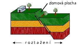 |
U poklesu kra v nadloží zlomu (nadložní kra)
poklesla proti druhé (podložní kre). Tento pohyb je zpusoben
tahovým napetím, dochází k rozširování deformovaného
prostoru. Zlomová plocha má zpravidla vetší úklon, nekdy je
až svislá. |
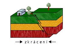 |
U zdvihu je presunována kra ležící nad zlomovou
plochou (nadložní kra) pres sousední kru (podložní kru).
Tento pohyb je zpusoben tlakovým napetím, dochází ke stesnávání
deformovaného prostoru. Podle úklonu zlomové plochy se
rozlišují presuny (úhel do 30°) a presmyky
(úhel nad 30°). U ležatých zdvihu (presunu) bývají nekdy
nadložní kry presunuty na velké, až kilometrové
vzdálenosti. Temto poruchám se také ríká nasunutí. |
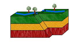 |
Horizontální posun se vyznacuje pohybem jedné nebo obou
ze sousedních ker v približne vodorovném smeru. Tento pohyb je
zpusoben strižným napetím. |
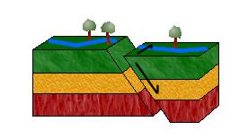 |
Smíšený typ zlomu je kombinací poklesu nebo
presmyku s horizontálním posunem - poklesové nebo
presmykové posuny. |
Posuny na zlomových plochách mohou být ruzne velké. Nekdy bývají
témer neznatelné, milimetrové až centimetrové, jindy metrové
až kilometrové. Velikost posunu vyjadrujeme pomocí
velikosti snížení jedné kry proti druhé (vertikální
amplituda) nebo pomocí velikosti jejich vzájemného
horizontálního posunutí (horizontální amplituda). Vertikální
amplituda poklesu se nazývá také výškou poklesu
(výškou skoku).
Pražský zlom
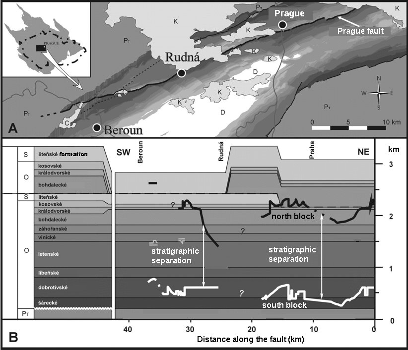
Pražský zlom je velkou poruchou zemské kury sv.-jz. smeru,
kterou lze sledovat z území Prahy až na Berounsko.
Pražský zlom je pokládaný za duležitý zlom aktivní behem
ordoviku a siluru. Pokles severnejší kry proti kre
jižnejší dosahuje tisícimetrového rádu.
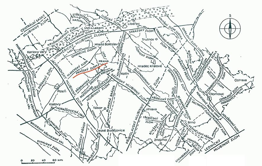
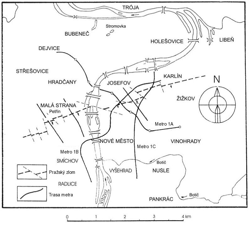
Pražský zlom je nejvýznamnejším zlomem v oblasti
pražské pánve. V bližším okolí Prahy ho lze
sledovat od Rudné pres Motol, Žižkov, Hloubetín až
ke Kyjím, kde se norí pod uloženiny svrchní krídy. Maximální
výška skoku dosahuje až 1700 m a to na
Žižkove, západním smerem se však zvolna
snižuje. Podle V. Havlícka (1963, 1998) je pražský zlom
poklesová porucha, puvodne velmi strme uklonená. Pražský zlom
byl pretat nekolika mladšími presmyky, které se oznacují
jako presmyky libenské (Röhlich 1960, Havlícek 1963, Vorel 1982),
presun podél jednoho presmyku se dá odhadovat pouze ve stovkách
metru. Presunové plochy jsou doloženy ve štole pro
silnicní tunel pod Strahovem, v tunelu pro kmenovou stoku K pod
Petrínem, v tunelu metra tras A a B na dolním konci Václavského
námestí, v kabelovém tunelu v Jindrišské ulici, v tunelu pod
vrchem Vítkov, na Krejcárku pod Žižkovem aj.
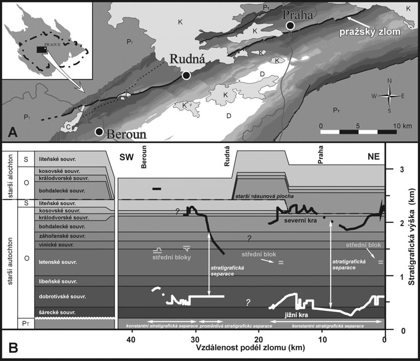
Pražský zlom je nejdelším zlomem v pražské pánvi a
má délku okolo 60 km. Tento zlom na povrch vystupuje v jediném
míste a to v Hloubetíne. Podle tohoto jeho jediného výchozu je
témer vertikální. V následujícím diagramu stratigrafické separace
si mužeme prohlédnout polohu severní a jižní kry podél
celého zlomu (~1600 m).
Pražský zlom a železnicní tunely pod
Vítkovem
Na pražský zlom narazili také stavbari pri ražbe tunelu
Nového spojení pod vrchem Vítkov. V letech 2005-2006 byly jako
soucást stavby Nového spojení v Praze proraženy dva paralelní
železnicní tunely pod vrchem Vítkov. Zhruba paralelne s osou
stavby probíhá pásmo pražského zlomu. Zlomové pásmo zasahuje
území pres 100 m široké. Ražba vítkovských tunelu byla
jedinecnou príležitostí ke studiu jednoho ze zajímavých úseku
pražského ordoviku v oblasti pražského zlomu.
 |
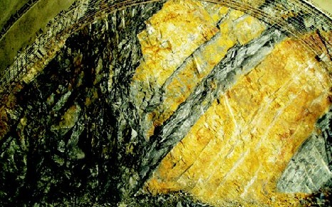 |
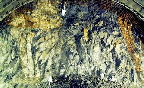
Na obrázcích si mužeme prohlédnout snímky celeb horní cásti
jižního tunelu, porízené behem ražby. (Polomer tunelového
oblouku je 6 m, smer pohledu od VSV k ZJZ. Foto E. Straka.) Jsou na
nich videt zlomy. Do tunelu se ale nechodte podívat, vše je
již odvrtáno nebo prestríkáno betonem.
Prírodní památka Pražský zlom
 |
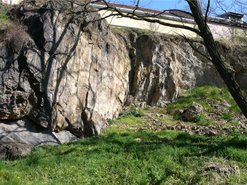 |
| (Foto: M. Štastný, 2007) |
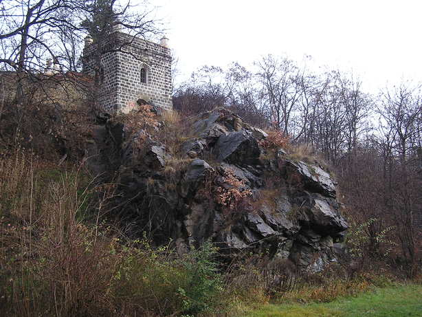
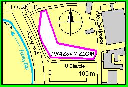
Prírodní památka Pražský zlom se nachází v Praze v Hloubetíne
na pravém brehu Rokytky na ZJZ od kostela sv. Jirí, S. od
hrište Slavoje Hloubetín, podél ulice U Slavoje. Jsou zde
zachovány ordovické kremence a bridlice. Tento skalní výchoz je
jediným prístupným odkryvem pražského zlomu. Na povrchu se
stýkají v jedné úrovni ruzne staré horniny. Chráneným územím byla
plocha vyhlášena v roce 1988. Rozkládá se na ploše
0,36 ha. Na skalním výchozu je postaven Hloubetínský zámecek.
Jihozápadní cást odkryvu smerem do údolí Rokytky je zrejme puvodní,
nenarušená težbou, zatímco jižní cást odkryvu
podél ulice U Slavoje byla narušena príležitostnou
težbou kremencu, ukoncenou nejpozdeji pred druhou svetovou
válkou.
Prírodní památka Pražský zlom je izolovaný výchoz skaleckých
kremencu, oddelených dislokacním pásmem pražského zlomu od
severneji položených jílovitých bridlic pravdepodobne
zahoranského souvrství. Plocha zlomu je viditelná na kremencích v
západní cásti odkryvu, a to na severním okraji výchozu skaleckých
kremencu.
Podle nalezené fauny a petrografického charakteru patrí jemne
slídnaté, hnedé, jílovité bridlice, tvorící podloží skaleckých
kremencu, zahoranskému souvrství. Skalecké kremence tvorí masivní
až nezretelné lavice, jejichž mocnost je ruzná
(nejmocnejší lavice má okolo 5 m). Místy jsou kremence
tektonicky podrcené v souvislosti s pohybem podél pražského
zlomu. Ve stratigrafickém nadloží jsou jílovité bridlice
dobrotivského souvrství. Vlastním postsedimentárním posunem podél
pražského zlomu došlo k zaklesnutí severní kry proti
jižní a tím se mladší zahoranské souvrství (beroun,
ordovik) stýká s horninami dobrotivského souvrství (beroun,
dobrotiv). Výška posunu je minimálne 900 m. Pražský
zlom mel v ordoviku a siluru velký význam pro vývoj pražské
pánve.
Pro zápis platného "cache found"
logu:
1) nám poslete e-mailem pres GC-profil odpovedi na následující
otázky:
- Jaká je délka pražského zlomu (v kilometrech)?
- Jaký je smer pražského zlomu (pomocí svetových
stran)?
- Kterým typem zlomu je pražský zlom podle pohybu oddelených
ker po zlomové ploše?
- Jakého rádu je výška skoku pražského zlomu
(jednotky, desítky, stovky ci tisíce/milimetru, centimetru, metru,
ci kilometru)?
- Na kterou svetovou stranu od pražského zlomu je
nadložní kra, která poklesla?
- Od waypointu PZ2 uvidíte plochou témer vertikální skalní stenu
(viz spoiler - v levé polovine fotky). Jaká je její horizontální
orientace - azimut (tedy úhel, který svírá tato stena se severním
smerem)? Merte z chodníku z vhodného místa v blízkosti lampy s
císlem 908487.
2) na stránku cache mužete uploadovat
fotografii vás s GPS a cástí prírodní památky Pražský zlom u
úvodních souradnic. Tato fotografie je nepovinná a není podmínkou
uznání logu.
Necekejte na schválení logu, muzete zalogovat "found" a poslat
odpovedi, provedeme následne kontrolu a pokud neco nebude v
porádku, ozveme se...
Prístup ke kešce
V Hloubetínské ulici je možné zaparkovat na nekolika
parkovištích, nejbližší ke kešce a asi i
nejprázdnejší je na souradnicích N 50° 06.200 E 014° 32.103
(waypoint PZP). Pujdete-li od tohoto parkovište ulicí U
Slavoje, budete na souradnicích N 50° 06.170 E 014° 32.052
(waypoint PZ2) po pravé strane míjet skály, které jsou soucástí
prírodní památky Pražský zlom. Poté sejdete po schodech a
dostanete se na úvodní souradnice N 50° 06.173 E 014° 31.990
(waypoint PZ1), odkud uvidíte fotogenictejší cást této
prírodní památky. Kdysi bývaly na obou místech, nad schody i pod
schody, cedule Prírodní památka, v dobe publikace kešky
zbyla po horní ceduli jen tycka, a po spodní ani ta ne.
Pokud pojedete MHD, vystupte na stanici Hloubetín metra B, pak se
mužete svézt ješte jednu zastávku na stanici Kbelská,
bud tramvají, napríklad linkou 3, nebo autobusem 110. Ze stanice
Kbelská mužete jít na úvodní souradnice (waypoint PZ1) po
chodnícku, který vede rovnobežne s Prumyslovou ulicí. Na
waypoint PZ2 se odtud dostanete po schodech nahoru.
V tráve v okolí skály u úvodních souradnic (waypoint PZ1)
mužou být klíštata, zejména v léte, ale pro splnení
podmínek logu není potreba scházet z chodnícku.
Podekování
Dekujeme geokamarádovi jarda3066 za korektury anglické cásti
listingu.
 |
EN: |
The initial coordinates are located in the position, where the
Prague Fault goes through. Its only exposure is accessible here,
the Natural Monument Prague Fault. First of all, we will say
something about the geological faults generally, then we will
mention the Prague Fault, and at the end we will describe the
Natural Monument Prague Fault.
Several words about the geologial faults
The fault is the disruption of tectonic origin. It is the
dislocation of rocks in the terrestrial crust, it interrupts their
primary continuity and the slip of adjacent blocks takes place
here. This slip leaves the noticeable marks sometimes. There are
smooth-faced planes (the tectonic slickensliding or the
faulting polish), or the systems of channels (tectonic
trails), which indicate the direction of movement of the
adjacent block. The rocks are crushed in the faults frequently and
they create the zones of tectonical breccias and
mylonites with the thickness of several metres or narrower.
The dip of the fault planes varies. Some of them are horizontal,
the others are vertical. The dislocations on the earth surface
present themselves as fracture lines with the length up to
several hundreds of kilometres. The large disturbances are formed
by the line of shorter faults, following each other and so they
mutually blend. In other cases, they consist of the system of
approximately parallel dislocations, which ramify frequently and
they create the massive fault zones or shear
zones.
Many of large faults are still tectonically active. For
example, the 1906 San Francisco earthquake was caused by a rupture
on the San Andreas Fault. This strike-slip fault goes along Pacific
coast of California, and is about 1300 km long. The earthquake
ruptured the northern third of the fault on a distance of 477 km.
The maximum observed surface displacement was about 6 m. This time
the magnitude was estimated to be 7.8. The earthquakes of magnitude
6.0 occur almost regularly at this fault, the last struck in the
small town Parkfield in California in 2004.
Two sides of a non-vertical fault are called the hanging wall and
footwall. Faults can be categorized into four groups based on the
sense of slip. A fault where the relative movement (or slip) on the
fault plane is approximately vertical is known as a dip-slip
fault. Dip-slip faults can be again classified into the types
"normal" and "reverse". Where the slip is
approximately horizontal, the fault is known as a transcurrent or
strike-slip fault. An oblique-slip fault has non-zero
components of both strike and dip slip.
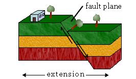 |
Normal Fault
In a normal fault, the block above the fault moves down relative to
the block below the fault. The hanging wall moves downward,
relative to the footwall. This fault motion is caused by tensional
forces and results in extension. [Other names: normal-slip fault,
tensional fault or gravity fault]
|
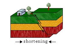 |
Reverse Fault
In a reverse fault, the block above the fault moves up relative to
the block below the fault. The hanging wall moves up relative to
the footwall. This fault motion is caused by compressional forces
and results in shortening. A reverse fault is called a thrust fault
if the dip of the fault plane is small, less than 30°. [Other
names: thrust fault, reverse-slip fault or compressional
fault]
If the angle of the fault plane is low (generally less than 20
degrees from the horizontal) and the displacement of the overlying
block is large (often in the kilometre range) the fault is called
an overthrust.
|
 |
Strike-slip Fault
In a strike-slip fault, the movement of blocks along a fault is
horizontal. The fault motion of a strike-slip fault is caused by
shearing forces. [Other names: transcurrent fault, lateral fault,
tear fault or wrench fault] |
 |
Oblique-slip Fault
Oblique-slip faulting suggests both dip-slip faulting and
strike-slip faulting. It is caused by a combination of shearing and
tension of compressional forces. |
The size of the movement on the fault planes can be various. The
movement can be imperceptible, the order of displacement magnitude
can be millimetres to centimetres, otherwhile the order can be
metres to kilometres. The size of the movement is expressed by the
size of the moving down one block relative to the second one
(vertical magnitude), or by the size of the relative
horizontal movement of the blocks (horizontal magnitude).
Vertical magnitude of the normal fault is also called the fault
throw.
Prague Fault
The Prague Fault is the large disruption of the earth crust in
NE-SW direction. It is possible to observe it from the Prague up to
Beroun region. On the map below the Prague Fault is highlighted by
the red line. The Prague Fault is considered as an important fault
active during Ordovician and Silurian periods. The northern block
moved down relative to the southern block with thousand metres
order of displacement magnitude.

The Prague Fault is the most important fault in the Prague
territory. Near the Prague it is possible to observe it from Rudná
through Motol, Žižkov, Hloubetín up to Kyje, where it
plunges below deposits of Upper (Late) Cretaceous. The maximal
vertical displacement on the fault amounts to 1700 m at
Žižkov in Prague, westward it slowly decrements. Havlícek
(1963, 1998) classified the Prague Fault as a normal fault, with
steep dip. It has been stated that the Prague Fault is dissected by
younger longitudinal thrusts named Liben Thrusts (Röhlich 1960,
Havlícek 1963, Vorel 1982), the displacement along one thrust may
be estimated only at hundreds of metres. Thrust planes are
documented in the road tunnel under Strahov, in the tunnel for the
interceptor K under Petrín, in the tunnel of the tube train of the
line A and B at the lower part of the Wenceslas Square, in the
cable tunnel in Jindrišská street, in the tunnel under
Vítkov hill, at Krejcárek under Žižkov and so on.
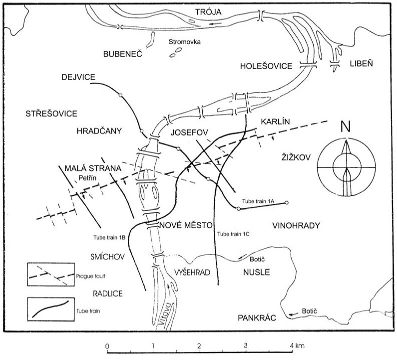
The Prague Fault is the longest fault in the Prague Basin and is
about 60 km long. The Prague Fault is vertical on the only
measurable outcrop in Hloubetín in Prague. On the stratigraphic
separation diagram on the following picture we can overlook
position of the north and the south block along whole fault (~1600
m). The stratigraphic height is on the vertical axis.
The Prague fault and the railway tunnels below Vítkov
hill
The builders hit into the Prague Fault during tunnelling the New
Connection below the Vítkov hill. Two parallel railroad tunnels
were born as a part of the New Connection structure under the
Vítkov hill in the years 2005-2006. The zone of Prague Fault is
situated nearly collinearly to the axis of the tunnels. The range
of the fault region is larger then 100 metres. The drilling of
Vitkov tunnels was the unique possibility to study one of the
interesting parts of Prague Ordovician in the region of the Prague
Fault.
 |
 |
On the pictures we can see the photos of the drift faces of the
upper part of the south tunnel. They were taken during tunnelling.
(The radius of the tunnel arc is 6 m, the view direction is from
ENE to WSW. Photo by E. Straka.) On the pictures you can see the
faults. Do not go to tunnels to see the fault, it was drilled off
or was resprayed by concrete.
The Natural Monument Prague Fault

 |
 |
| (Photo: M. Štastný, 2007) |
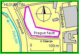
The Natural Monument Prague Fault is located in Prague in Hloubetín
on the right bank of Rokytka. It is in the WSW direction from the
St. Jirí church and in the N direction from Slavoj Hloubetín
playing area along the U Slavoje street. The quartz rocks and
bluestones are preserved here. This fault outcrop represents the
only accessible exposure of the Prague Fault. The rocks with
different age meet on the same level on the earth surface. This
surface was declared as the protected area in the year 1988. It
lies on the surface 0,36 ha. The Hloubetinsky manor is constructed
on the rock outcrop. The SW part of the outcrop in the direct of
the valley of Rokytka is original, undisturbed by mining, whereas S
part of the outcrop along the U Slavoje street was disturbed by the
quartzite mining, which was terminated before World War II at the
latest.
The Natural Monument Prague Fault is the separated outcrop of
Skalka quartz rocks, which are separated by the dislocation fault
belt of Prague Fault from the clay shale, which are situated more
to the north. These clay shale probables belongs to Zahorany
formation. The fault plane is visible on the quartzites in the west
part of the exposure, namely at the north border of the Skalka
quartzite outcrop.
According to the local fauna and the petrographic disposition, the
softly micaceous brown clay shale belong to the Zahorany formation.
The clay shale creates the bedrock of Skalka quartz rock. The
Skalka quartz rock constitutes solid banks, which thickness is
different (the value of maximum thickness of the bank is
approximately 5 m). The quartz rocks are tectonically broken
according to the movement along the Prague Fault on several places.
Clay shale of Dobrotivá formation are located in the stratigraphic
rock cover. Due to postsedimentation movement along the Prague
Fault, the moving down of north block relative to the south block
takes place. Thus the younger Zahorany formation (Beroun,
Ordovician period) meets with the rocks of Dobrotivá formation
(Beroun, Dobrotiv). The value of the fault displacement is
minimally equal to 900 m. During the Ordovician and Silurian
period, the Prague Fault was very important to the development of
the Prague Basin.
The way to valid "cache found"
log:
1) send us answers to following questions by e-mail using
GC-profile:
- the lenght of the Prague Fault (in kilometres);
- the direction of the Prague Fault (using cardinal points);
- into which group of faults (based on the sense of slip) does
belong the Prague Fault;
- the order of magnitude of fault displacement of the Prague
Fault (ones, tens, hundreds or thousands / milimetres, centimetres,
metres, or kilometres);
- at what cardinal point from the Prague Fault it is the hanging
wall, which moved down?
- From the waypoint PZ2 you will see the flat almost sheer rock
side (see spoiler - on the left half of photo). What is its
horizontal orientation (azimuth)? Measure from the pavement from
the suitable point in the vicinity of the lamp with number
908487.
2) you can upload a photo of you with your
GPS and a part of Natural Monument Prague Fault at the initial
coordinates to your log. This photo is optional, it is not
necessary for your valid log.
Do not wait to our confirmation, you can log found and send us the
answers. We will check your solution, if it will contain errors, we
will email to you ...
The approach to the cache
In Hloubetínská street you can park your geocar at several parking
areas. The parking area at N 50° 06.200 E 014° 32.103 (waypoint
PZP) has probably some free places and it is the closest one to the
cache. From here we can go along the street U Slavoje to the point
with the coordinates N 50° 06.170 E 014° 32.052 (waypoint PZ2). At
our right hand we can see the rocks, which form the part of the
Natural Monument Prague Fault. Then we continue down the stairs and
we come to the initial coordinates N 50° 06.173 E 014° 31.990
(waypoint PZ1). From here we can see more photogenic part of this
Natural Monument. Formerly, two marks "The Natural Monument" were
located here. One mark was placed above the stairs and the second
one was placed down the stairs. In the time of this cache
publication, only a rod above the stairs survived.
When you use the public transport, you can get off the subway line
B at Hloubetín station. Then you can take the tram line 3 or the
bus line 110. Get off at the next stop at the station Kbelská. From
the Kbelská station you can go to the published coordinates
(waypoint PZ1) along the pavement, which is parallel to the
Prumyslová street. To the waypoint PZ2 you can walk up the
stairs.
A plenty of ticks can be found in the grass in the neighbourhood of
the published coordinates (waypoint PZ1), especially in the summer.
To complete your mission, you don't have to leave the
pavement.
Acknowledgements
Thank geofriend jarda3066 for the correction of the English part of
the listing.
Literatura / References
- http://www.geology.cz/app/glok/glok_cz.pl?id_=214&tt_=z
- http://envis.praha-mesto.cz/rocenky/CHRUZEMI/cr2_cztx/CHU57.htm
- http://envis.praha-mesto.cz/rocenky/NEZIVA/kap13.htm
- http://www.iris.edu/gifs/animations/faults.htm
- Q.
Záruba, J. Vachtl, M. Pokorný, Základy geologie a petrografie pro
stavební fakulty, SNTL, Praha, 1974.
- O.
Zeman, Petrografie a regionální geologie Ceského masívu,
vydavatelství CVUT, 1994.
- Pavel
Röhlich, Structure of the Prague Basin: The deformation diversity
and its causes (the Czech Republic). Bulletin of Geosciences 82(2),
175-182 (5 figures). Czech Geological Survey, Prague. ISSN
1214-1119. (http://www.geology.cz/bulletin/contents/2007/vol82no2/bullgeosci200702175.pdf)
- Pavel
Hájek, Martin Štastný, MINERALOGY OF THE CLAY GOUGE ON
PRAGUE FAULT, Acta Geodyn. Geomater., Vol. 4, No. 3 (147), 33-37,
2007 (http://www.irsm.cas.cz/abstracts/AGG/AGG3_147/4_Hajek.pdf)
- Eduard
Straka, Pavel Röhlich, TEKTONICKÉ PORUŠENÍ ORDOVIKU V
TUNELECH NOVÉHO SPOJENÍ V PRAZE 3 (VRCH VÍTKOV) Tectonic
deformation of the Ordovician in the New Connection tunnels in
Prague 3 (Vítkov Hill), Geoscience Research Reports for 2007, Czech
Geological Survey, Prague, 2008, ISSN 0514-8057 (http://www.geology.cz/zpravy/obsah/2007/2007-16.pdf)
- Martin
Šindelár, Petr Budil, Radek Mikuláš, Eduard Straka,
Jirí Krupicka, ETAPOVÁ ZPRÁVA Z TERÉNNÍ DOKUMENTACE LINIOVÉ STAVBY
NOVÉ SPOJENÍ V PRAZE, Zprávy o geologických výzkumech v roce 2005,
53-57. (http://www.geology.cz/zpravy/obsah/2005/zpravy-o-vyzkumech-2005-str-053-56.pdf)
- M.
Knížek a R. Melichar, MYSTÉRIUM PRAŽSKÉHO ZLOMU
(BARRANDIEN),3. SJEZD CESKÉ GEOLOGICKÉ SPOLECNOSTI, VOLARY 19.-22.
ZÁRÍ 2007, pp. 37 (http://www.geologickaspolecnost.cz/soubory/dokumenty/volary-2007/abstrakty/3sjezdCGS_abstrakty
37.pdf)
- M.
Knížek, R. Melichar, J. Janecka, Diagram stratigrafické
separace - jednoduchá pomucka pro analýzu zlomu v barrandienu,
Spolocný kongres Slovenskej a ceskej geologickej spolocnosti, 2009,
pp. 96 - 97
- http://en.wikipedia.org/wiki/San_Andreas_Fault
- http://en.wikipedia.org/wiki/1906_San_Francisco_earthquake
- http://en.wikipedia.org/wiki/Parkfield_earthquake