Little Imber on the Down
Seven miles from any towne.
Ship bleats the unruly sounds.
Life twer sweet, with ne'er a vrown,
Oh let us bide on Imber Downe.
Thumbnail History of Imber (from the Wiltshire Council web site)
Imber is the ghost village of the Salisbury Plain. Kelly’s directory for 1939 tells us it has an ancient church and a Baptist Chapel, that it has an area of 3,052 acres and in 1931 its population was 152. It also says that the soil is flinty, the subsoil chalk and that the chief crops are wheat, oats, barley and pasture. Ominously it also records that the principal landowner is the War Office.
Although there is evidence of prehistoric and Roman settlement in the area, the first documentary mention of Imber is in 967, when it was part of an endowment to the Abbess of Romsey. It is mentioned in Domesday as being held by Ralph of Mortimer, but this probably only referred to that part of the village not held by Romsey Abbey. It has been estimated that the population at that time was about 50. By 1377 the population had risen to 250, probably remaining at that level till the nineteenth century. By 1801 it had risen to 331, by1851 it had reached a peak of 440. Then it commenced a decline, to 339 in 1881, 261 in 1901, till by 1931 there were just 152 inhabitants.
Imber was a community dependent upon agriculture. Those who were not directly employed on the land were in trades dependent upon it. The decline in population is also reflected in a decline in activity. The directory of 1867 lists 6 farmers, a tailor (and shopkeeper), a miller (and Innkeeper), a boot and shoemaker and a blacksmith (and shopkeeper). Whereas the 1939 directory lists 4 farmers, a smallholder, an innkeeper, a carpenter and a blacksmith.
The village was in quite an isolated position, sheltering in a fold in the downs some four miles from the nearest village. It was elongated in shape, its main street following the course of a stream known as “Imber Dock”. The only building still more or less intact is the church. This was described in the 1939 directory as “an ancient and beautiful stone building of various dates, mainly in the decorated and perpendicular styles. It has an embattled western tower with five pinnacles and containing five bells”. The description of the interior mentions the effigies of two knights (now to be seen in Edington church). The Baptist chapel, built in 1839, is also mentioned (this was demolished some time ago and only the graveyard remains). Besides a number of substantial farmhouses, the main building of note was Imber Court. This was the manor house, rebuilt in the eighteenth century, burnt down in 1920 and subsequently restored. Refreshment was supplied by the Bell Inn.
What happened to Imber? From the late nineteenth century military manoeuvres had been held on parts of the Salisbury Plain and in 1897 the War Office began purchasing land in the South East of the plain. The first world war and after saw an increase in the need for such land and between 1927 and 1932 the War Office purchased a substantial part of the north and west of the plain. This included most of the village of Imber and its inhabitants became tenants of the military. In the Second World War the need for training areas intensified, especially in the preparations for D-Day. On the 1st November 1943 the tenants were given just 47 days notice to quit. Many of them left believing that they had been promised a return after the war. This was not to happen and it has been a military training area ever since. Much of the old village has since disappeared. In a final irony the army has built a mock village, for training purposes, on the edge of the old one.
For those wishing to learn more of the village your local library or Amazon will be able to obtain a copy of "Little Imber on the Down" by Rex Sawyer for you.
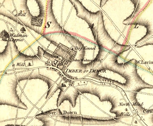
Imber in 1776
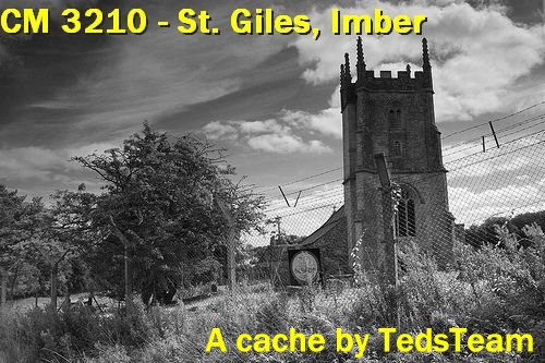
A short history of St Giles church
The church occupies the site of an earlier building dating from the mid-12th century. The nave was rebuilt towards the end of the 13th century and was followed, circa 1400, by the addition of the north and south aisles, the tower and north porch. At this time the nave roof was reconstructed. The chancel was rebuilt in 1849 at which time the north-east vestry was built.
The church was rich in fittings and furnishings which are now scattered among other churches in Wiltshire and Gloucestershire. However, some of the 13th and 15th century wall paintings survive.
The church served the inhabitants of Imber until the evacuation of the village in 1943.
During the early 1950s the War Office (now Ministry of Defence) undertook to keep the church in a modest state of repair until a decision was made as to its ultimate future. This undertaking came to an end in 2002 when responsibility for the building reverted to the Diocese of Salisbury. In 2005 this Grade I listed building was vested in The Churches Conservation Trust for preservation and repair. With assistance from the Ministry of Defence, the Trust has carried out a comprehensive campaign of repair and conservation to the building and its wall paintings.
There is a very informative leaflet available in the church
The cache
| Please Note: To obtain information to find this cache you will be entering a Military Training Area on which live firing and other pyrotechnics ARE used. The area is only open to the public at stated times. One of the safety rules for public access is:- Do not, (and ensure that children do not) approach, touch or pick up any metal objects lying on the ground. Please obey all bylaws and locally posted information concerning times when the area may be closed. These may be physical barriers, flags or lights.
You may find more information about MOD Managed Access Land HERE. And specifically about Salisbury Plain HERE
|
To find this cache you must first visit and enter the church and churchyard of St. Giles, Imber. However, as you'll have deduced from the above, the church is now situated in a MOD live firing range and access to it is somewhat restricted.
The following Imber Range opening dates have come from the MOD but ARE SUBJECT TO CHANGE. Obviously, the Church can only be open at some time during these dates/
| The EASTER opening dates for 2023 are :- |
| The CHURCH will be open fromm 11.00 to 16.00 on April 7th, 8th & 9th and 11.00 to 15th on April 10th |
|
|
IMBERBUS DAY
TBA. Access is by bus only from Warmister.See their website (www.imberbus.org) for details.
|
REMEMBRANCE DAY SERVICE
The VILLAGE will only be open for the church service. Access via Warminster ONLY (see below).
The CHURCH
TBA
The Service of Remembrance is to be held on Saturday November 12h. All those attending must be at the Waterloo Lines Vedette Post No 2 Warminster no later than 1020 hours for the escorted convoy to Imber church. The service will commence just before 1050 hours. |
|
CHRISTMAS opening dates are as follows:-
The CHURCH will be open as follows:
TBA
|
To find out more about the church and up to the minute news on when it is open, visit Imber Church Opening Times. Access to the church is free of charge.
Note that the church is not necessarily open at the same time as the village. Do your research to avoid disappointment.
DO NOT EVEN CONTEMPLATE ATTEMPTING TO ACCESS THE CHURCH AT ANY OTHER TIME - THIS IS A LIVE FIRING RANGE AND YOU MAY GET ARRESTED, SHOT OR BLOWN UP (or even all three!)
Having determined when you can gain access to the church it is wise to get to the village as early in the morning as possible. During its open days, Imber can attract large crowds and then it is impossible to get a true feel for your surroundings and what the village was like. Go early and enjoy the loneliness and tranquility.
OK, so you've arrived at the church. All you have to do is answer the following question before finally doing the calculations
|
IN THE CHURCHYARD
EITHER
Look for the headstone of John Meaden who died in 1906. At the foot of the stone is another to William Meaden who died in 2005. Let ABCD be the year William Meaden was born.
OR
Look for the headstone of "Floss Butcher" who died in 2012. Let ABCD be the year she was born PLUS 4.
|
INSIDE THE CHURCH (take a torch in winter - there is usually no electric lighting)
Locate the stone to John Wadman who died on the 3rd of October 1688. Let EF be "ye year of his age".
You will now need to do a bit of decoding. The answers to the next two questions are letters which you must translate to numbers by using the simple code of A=1, B=2 ... Y=5, Z=6
There is a plaque commemorating the restoration of the church in 1896. The names of the two churchwards are given and they are both called Dean. Let GH be the initials of the upper Mr. Dean and JK be those of the lower Mr. Dean.
Finally locate the war memorial. It is unusual in the it lists all villager's who served in the Great War, not just those who died. Interestingly it also marks the names of those who were injured and the poor man who was both injured and taken prisoner. Let LM be that poor man's initials
The cache is located on a public right of way, outside the firing range, at
NEW FORMULAE AS OF 17th DECEMBER 2013
N51 MF.G(D-C)(H-G-M) W 00(J-G) (K-H)(M-A).MC(F-J)
Checksum - the total of ALL digits in the final co-ordinates is 28
THE FINAL CACHE IS NOT ON MOD LAND AND AFFORDS GREAT VIEWS. IT IS NOT A C&D BUT THE WALK IS WORTH IT
CONGRATULATIONS TO THE WOBBLY CLUB ON BEING FTF - you must've been up with the larks
If you want to add this souvenir to you profile copy it from here
NOTE, the location of the souvenir changed on 16th January 2020. If you linked to the source location simply change "burbage-wiltshire" to "kinwardstone" in the URL.