Ye Olde Allington Multi-cache
-
Difficulty:
-

-
Terrain:
-
Size:  (small)
Please note Use of geocaching.com services is subject to the terms and conditions
in our disclaimer.
Allington Lock cache is back and now it's a multi!
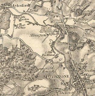
Anyone familiar with this area will know Allington is a suburb of Maidstone, located either side of the A20. However, Allington started life as a small village by Allington castle, by the river Medway and north of the modern Allington. In 1870 the village consisted of just 10 houses with a population of 66. Allington Castle was the birthplace of Sir Thomas Wyatt the poet, and his son Sir Thomas, who headed the insurrection against Mary I. More information about Allington can be found here: link.
Allington Lock was first built as a result of the Lower Medway Navigation Act of 1792. It was replaced in the 1840's and the current double set of locks were built in 1937. It is the first lock on the river (travelling upstream) and marks the river’s tidal limit.
This cache takes in the old village, the lock and the interesting boats moored nearby. There is limited parking outside of The Malta Inn car park(N51 17.762, E0 30.505)(The Malta Inn car park now appears to have ANPR), or alternatively at the park on the opposite side of the river (N 51° 17.467' E 0° 30.317'). Your total walking distance isn't much different from either location. You could also visit the nearby Museum of Kent Life or take a boat trip into Maidstone. It goes without saying but please take care of small children by the river - not all of the river bank has railings beside it.
Now for the important stuff: the clues to the cache!
The Boats - N51° 17.692' E0° 30.671'
An interesting range of boats - some old and some not as old as they look! Find the boat named Emanuelle, a Dutch barge, built in hijk.
The Sluice - N51° 17.745' E0° 30.405'
Plenty of places to sit around here and watch boats going by. When did the flood water here reach its highest level? Look carefully! (The internet will give you a much more recent date but you will need the one from the waypoint)The year was defg.
The Village - N51° 17.537' E0° 30.379'
Here you can see the entrance gate to Allington Castle and the old church (now a private residence). The number on the post box is ME16 abc.
Now use this formula to work out the final coordinates:
N51 17.(c-f)(b-k)(g+h+a) E0 30.((i-k)+f)(d+f)(k-f)
The cache is located in a public open space and can be accessed from either parking area (There is a gap in the fence). Keep an eye out for dog walkers though!
Additional Hints
(Decrypt)
Haqre n irel ynetr ebpx, oruvaq n oevpx