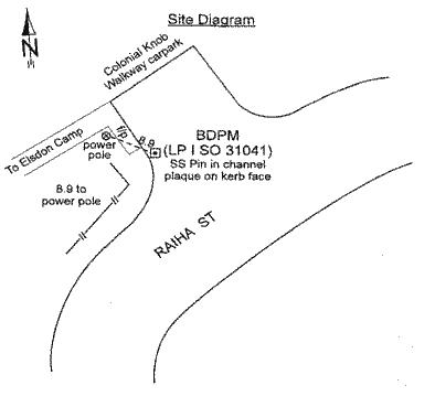
It's not an exciting location, just a tiny stainless steel pin
embeded in the kerb near the Elsdon Camp. The posted location will
get you close, and the map will help you refine your search till
you find it.
This cache is cloned with kind permission from M@ in Auckland
-see GCHQ2Y. He even shared his code and expertise to assist me in
setting this one up.
This site is
survey benchmark (BDPM) with an accurately determined position
that for the purposes of this exercise we will take as gospel. Linz
claims +- 0.01m placement accuracy, more than we will EVER get from
GPS I suspect ....
There once was a cache container nearby to keep things legal,
but the real objective of this cache is to learn about GPS error by
comparing the readings of different GPS units, at different times,
different conditions, etc. As a result, we can all learn about the
likely errors in placement or during the search for a cache.
Your web site log entry should contain the following
information. It MUST at least contain at least your lat/long
reading to constitute a find.
There are two ways to approach this:
1) Try you hardest to get as close to the target as you can with
your result. I dont intend it as a competition, and there are no
prizes, but this may appeal to some. (It really only makes sense to
log decimal degrees if you are serious about this option, hitting
the centre with decimal minutes is a bit of a Claytons.)
2) Treat the reading with the same degree of care as you
normally do on a placement or hunt. In this way you could learn
more about the likely errors you will encounter in your normal
cacheing activities.
Do both if you wish...
| Lat/Long: |
Ideally give your coordinates in decimal
degrees format, as this gives more precision than decimal
minutes.
|
| GPSr Make: |
GPSr Model / software version: |
| Time / Date: |
|
| EPE: |
Estimated Position Error |
| Waypoint Time: |
How long did you let the GPSr sit at this position
before taking the reading? Up to you if you average or not, (but
note it if you do please.) |
| Satelites in use: |
For each satelite with a fix, indicate:
and/or calculate the average reception.
or take a picture of the GPS display if you wish. |
| Extras: |
External antenna, car kit, any other comment you
wish |
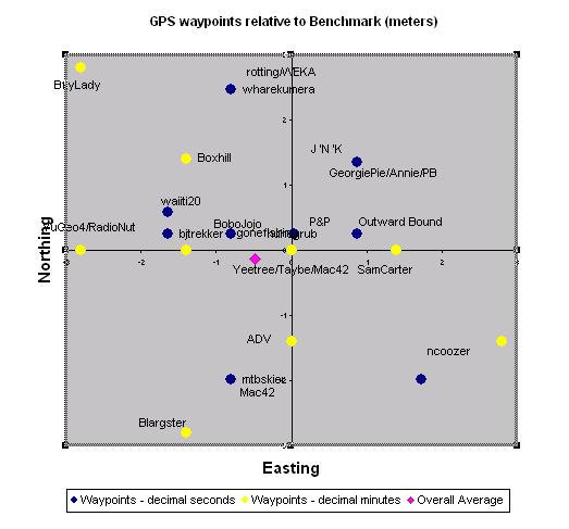
If I get enough interest and data to derive a statically
sensible answers, other graphs on EPE vs actual error, or
comparisons between GPS makes/models may appear, in the meantime
each log will be plotted on the graph below, showing their relative
positions from the benchmark coordinates.
The yellow blobs are those who logged lazily in decimal minutes,
and I expect there to be clusters of these if more of you choose
this option. The blue blobs are those who log correctly in
decimal degrees, and these should be more scattered in the fullness
of time. The pink blob shows the average of all logged finds.
What?
Oh, right, the physical cache - the repository for trinkets,
trash, log book and coins.... it was 25 m north(ish) from the pin
behind a post. small rectangular click-clack.Dont sweat if its not
here, seems to go missing regularly...
Pat "Jellybean" the donkey. By the time you have stood by the
benchmark for a while, he will have probably ambled over to check
you out. He doesnt bite much.