Quiet Breezes - 1st Indiana Wind Farm EarthCache
Quiet Breezes - 1st Indiana Wind Farm
-
Difficulty:
-

-
Terrain:
-

Size:  (not chosen)
Please note Use of geocaching.com services is subject to the terms and conditions
in our disclaimer.
The site of this earthcache is located in Earl Park, Indiana. It is
home to 87 wind mills with 1.5MW (megawatt) wind turbines. These
wind mills are providing an environment friendly source of
electricity. They were up and running in the Spring of 2008. There
are another 200+ windmills currently being installed around
Fowler.
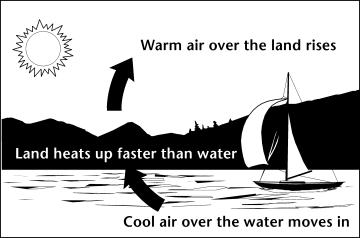
First off let's talk about wind. What is wind and what causes it?
Wind is air in motion. Believe it or not, the sun helps cause wind.
The sun heats up the earth, although it heats up the land and water
at different rates. The air above the land heats up quite a bit
faster. The hot air flows up into the sky and begins to cool. The
cooler air begins to flow out over the water. The cooler air begins
to settle downward exerting pressure on the air. This pressure
creates wind.
When you watch a weather report, did you ever wonder what they mean
by "gale" force winds? According to the Beaufort Scale, there are
actually four different kinds of "gale" classifications. They range
from 25.5 - 64 MPH. I've also heard people talk about wind using
the term knots, which turns out to be equal to 1.15 MPH. The chart
below will help you differentiate the two. 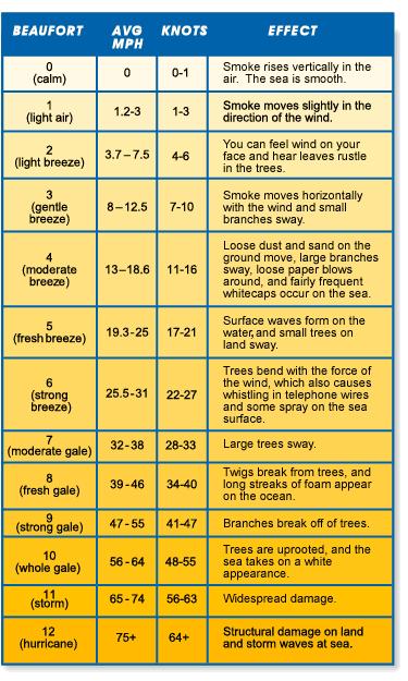
Wind power is a type of renewable energy. Renewable energy is
energy that regenerates itself or that cannot be depleted. In this
case it is created daily by sun rays. Just because you don't feel
wind at ground level, doesn't mean there is no wind 50' up in the
air or higher. Wind will never take over as our main source of
electricity, partially because the wind doesn't always blow.
However it is a low-impact source of energy and the more we can
take advantage of that the better of the environment will be.
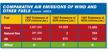
Unlike burning oil, natural gas, or coal, wind energy does not emit
pollution such as carbon dioxide, sulfur dioxide, nitrogen dioxide
or mercury. It was estimated that a 1.5 MW wind turbine taking the
place of a more common source of electricity generating source will
keep approximately 3,000 tons of carbon dioxide from the atmosphere
every year. The chart below demonstrates the differences in
emissions. So far the only environmental impact the wind farms
claim to have led to in some areas are changing birds flight paths
while migrating and the visual impact on the landscape (some people
like it, some don't).
Now let's talk about another important factor in selecting a
location, the land or terrain itself. Wind maps help in selecting a
site, but the actual terrain has a lot to do with it. Ideally your
location would be free from trees and buildings in all directions
and much higher than the surrounding area. Placing a wind farm in a
valley surrounded by trees and hills would not be a good choice.
Much of Indiana is glaciated, which causes it to be flat or having
some gentle rolls in the terrain. This glaciated area is what is
called the Tipton Till Plain (or Central Drift Plain). During the
Illinoian Age approximately 75% of the glacial deposits were left
in this area. Later, the Wisconsinan glaciers reached this area at
its furthest extents. These glaciers carried sediment along in them
and the deposits they left behind were called till, which is a
mixture of sand, silt, clay and boulders. Northern Indiana was
actually bedrock hills and valleys before the Ice Age. However the
till that was left behind leveled the terrain out in these parts
and gives us what Indiana is known for now, behing flat or gently
rolling.
As a guideline plains areas are the best for wind farm with roughly
93% of the area being exposed to the wind. Plains with hills are
rated at 79%, plains with mountains at 67%. Conversely mountain
summits have a rating of 3% beind exposed to the wind.
Finally, let's talk a little bit about the windmills you see around
you and their history. Windmills are not something new. People have
been milling corn and watering crops in Persia since the 1st
century with the use of wind mills. Most people think of Holland
when they think of windmills, however they were built in France,
England, and Asia in the 12th Century. The first electricity
generating windmill was actually built in the late 19th Century.
Ironically fossil fuel technology caused wind power to fall by the
wayside in the 19th and 20th centuries. But now with the price of
oil, environmental concerns, and wind turbines becoming more
efficient, wind power is once again alive!
The wind turbine is essentially made up of 5 main parts:
foundation, tower, nacelle, rotors, and the transformer. The wind
turns the rotor (or blades), which turns a generator (basically
copper wire and magnets) inside of the nacelle, which creates
electricity. The nacelle sits on top of the tower. The tower is the
long pole that gets the rotors up into the wind currents. The tower
sits on top of a foundation full of rebar and over 300 CY of
concrete. The transformer sits next to the tower and helps convert
the wind into energy.
2007 was a record year for the US wind energy industry. It
increased the nations capacity by 45% when it installed 5,244 total
megawatts. The US now has wind power in 34 states totaling 16,818
MW. In 2008 a little over 1% of our total electric supply will be
from wind farms (48kwh). It doesn't sound like much does it?
However that's equal to supplying around 4.5 million homes. As of
December 31, 2007, Texas led the way with 4,356 MW of wind power
capacity. There were only 6 states with more than 1,000 MW of
capacity (Texas, California, Minnesota, Iowa, Washington, and
Colorado). Experts are estimating that by 2015 we will be operating
at three times our current wind capacity.
Hopefully you learned a little something about wind and wind power.
Now for what you all came for, to get credit for this earthcache
you will need to answer some questions. Most of which can be
answered if you read this cache page. Answers need to be e-mailed
to the owner of the cache (within 48 hours of posting, same with
the pictures or the posting will be deleted - sorry, to many not
following up so far), DO NOT post on the website. The difficulty
level of 2 is just because of the math that is required. It might
be a little harder to calculate for some of the youngsters.
1. Post a picture of yourself on your log with any of these nearby
windmills in the background.
2. Estimate what Beaufort Scale reading the wind is while you are
at the cache, and tell me why you gave it that rating.
3. If a tri-axle dump truck hauls 20 tons per load, how many loads
of carbon dioxide is just one of the 1.5 MW wind turbines saving in
a year? (Extra credit, how many total loads for the entire 87 wind
mills in the wind farm per year - pretty impressive huh?)
4. If a 100 MW wind farm can power up to 45,000 houses a year,
approximately how many houses can this wind farm power per
year?
5. What makes up "till"?
6. Look at how the earth's formation is around here. Tell me what
about the land does or does not make this a good location for a
wind farm.
7. Finally, to prove you were at the coordinates, what day will
Memorial Day decorations be removed?
** As an added bonus, if we get some good pictures within the 1st
year from posting, maybe I'll have a little friendly photo contest.
I'll judge on 1. Best sunset / sunrise picture 2. Most creative /
crazy / original picture 3. Most people in the picture. Other
topics may come if I get some other ideas.
PLEASE NOTE: I will not be sending follow up requests for
answers any longer, if you don't complete the requirements, it will
be deleted. I've had to chase down to many people lately. Sorry
about that. To claim an Earth Cache you must follow through with
the requirements, not just visit the site.
Additional Hints
(No hints available.)