Rainy Lake Traditional Geocache
-
Difficulty:
-

-
Terrain:
-

Size:  (regular)
Please note Use of geocaching.com services is subject to the terms and conditions
in our disclaimer.
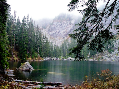
The trail to Rainy Lake is surprisingly well defined. Still, it is
not a maintained trail and is more challenging than your average
northwest forest trail. Expect 7-8 miles round trip and a gain of
2,800 feet. There was also a not-so-insignificant stream crossing
that may be better in the summer. Bring your gaiters, the 10
essentials, and a buddy for this one.
To get there, take I-90 to exit 34. Pick up the Middle Fork Road
and travel about 11 miles to the Gateway Bridge parking area at N47
32.865 W121 32.220 (Northwest Forest Pass required). Cross the
bridge and turn right downstream. At approximately N47 32.594 W121
32.656, find the junction for the trail to Rainy Lake. For the most
part the trail follows Rainy Creek to the Lake making for many
views of small and not so small waterfalls. At around 2,000 feet,
the trail reaches the boundary of the 1930’s clear cutting of
the valley floor and passes into old growth. The trail gradually
heads away from the creek to avoid cliffs and then at about 3,300
feet the trail takes a hard left and traverses ESE into the lake
basin.
We ran into some spotty satellite reception at the cache site,
which is reflected in the higher difficulty rating. But, no one
wants to hike all this way for a DNF, so check the descriptive
hint. You’re looking for an ammo can.
| WARNING: Cache seekers assume all risks,
responsibilities, and mental condition involved in seeking this and
any cache. Make sure you are prepared (ie bring a buddy and the
10
essentials) and that your skill level matches your
ambition. |
Additional Hints
(Decrypt)
Hcuvyy sebz gur ynxr, bss-genvy nobhg 30 srrg. Oruvaq n gnyy fant ba n ebpx funcrq yvxr n oybpx.