This EarthCache
does not require you to go into the Pit to log it as a find. Do not
take children or pets to this EC location. It’s a very dangerous
opening. There’s a traditional geocache at the bottom of the pit
that can be accessed by rappelling 100 "free fall" feet to the
bottom. To get back out you will need mechanical ascenders and
ascend 100 feet back to the opening. Do not even try climbing into
the opening. There is nothing to grab onto, or climb on. Its
impossible to climb out of the cave unless you have mechanical
ascenders or you are mechanically hoisted out by a cable
wench.
Wind Cave Pit is not widely known and reportedly has not been
explored since the mid 1980s.
It was once thought possible that Wind Cave Pit could connect to
Wind Cave itself but extensive exploration by several caving groups
concluded that it basically goes nowhere. Once on the bottom you
will find no leads. Those who have explored it in the past may have
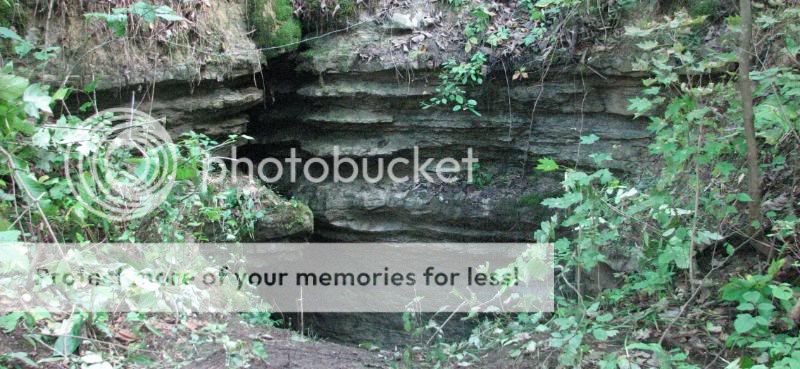
overlooked something. When you visit the EC site, all you will see
is the opening of the pit cave. Observation of Wind Pit Cave can be
done from a distance. Be warned that it’s a very dangerous opening.
If you get to close you could slip into the opening and plunge 100
feet resulting with serious injuries or death. There are bones of
animals lying at the bottom of the pit that are visual testimony to
what will happen if anything living falls into the pit.
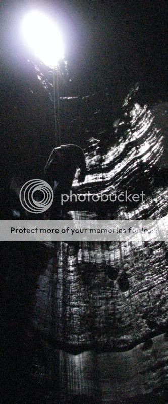
Geology of Wind Pit Cave
Wind Pit Cave, is classified as a "pit" cave, and a type of
natural cave which is a vertical shaft rather than a horizontal
cave passage. Pit caves typically form in limestone as a result of
long-term erosion by water. Pit caves can be open to the surface or
found deep within horizontal caves. A pit is generally categorized
as a vertical drop of any depth that cannot be negotiated safely
without the use of ropes or ladders.

In caving parlance, a domepit is a large vertical underground
shaft in which water flowing down to the water table at a lower
level has dissolved a cylindrical cavity in the rock.
Wind Pit Cave is formed in the St Louis Limestone formation. The
St. Louis Limestone is the principle cave forming units in Pulaski
County, constituting the Monteagle Limestone. The Monteagle
correlates to the upper two members of the Newman Limestone in
Rockcastle and Jackson counties, and itself is made up of two
member units. Overlying the St. Louis is the lowermost of these two
units, the Ste. Genevieve Member, equivalent to the Ste. Genevieve
of the Newman. Above is the Kidder Limestone Member of the
Monteagle. The St. Louis, Ste. Genevieve and Kidder members are
much thicker than their equivalents in Rockcastle and Jackson
counties due to a regional thickening of these rock units to the
south.
In Pulaski County the Mississippian and Pennsylvanian rocks
maintain their southeasterly dip. There is no significant break in
the structure until well into Wayne County. The normal variances in
the structures are due to the rises and swells of the sea floor
when these rocks were deposited.
These limestones exhibit similar characteristics as other neaby
types of Limestone in Kentucky, although they generally are
thicker. The thicker beds allow more variety in cave, development
throughout the section.
Wind Pit Cave exploration
Exploration into pit caves "vertical caving", also called "pit
caving", requires the use of equipment such as nylon kermantle rope
or cable ladders. More specialized caving techniques such as the
single rope technique are common practice and the preferred method
of pit exploration for cavers worldwide. The SRT involves the use
of nylon static rope and mechanical descenders/ascenders.
Vertical caving is a specialized sport that should be undertaken
only after acquiring knowledge of, and expertise in, proper
vertical caving equipment and its use. For obvious reasons,
vertical caving is more dangerous than "horizontal caving".
Vertical caving requires the intimate understanding of ropes,
knots, anchors, rappelling devices and ascending systems. Veteran
cavers typically are knowledgeable in self rescue techniques
including change-overs (the act of switching from rappel to climb
while on rope) and pick-offs (the act of rescuing a stranded caver
from their rope and returning them to the ground).

Cave history of Pulaski County
Although history is four dimensional, my knowledge of the
history of Pulaski County caves is pretty much linear, based on my
own limited experience.
Prehistoric: Many caves were used as shelter, particularly south
facing sites above streams such a Buck Creek or Cumberland. Springs
were also a source for water. From multiple artifacts plowed up in
fields near Short Creek, a settlement may have been built there.
Caves were also used as burial. We found vertebrae and other bones
in a cave overlooking the Cumberland that had been looted. Bowling
Alley Cave near Somerset was reputed to have an Indian scull in
it.
Late 18th and 19th centuries: Settlers used springs for water
and making whiskey, which was an important means of commerce. Salt
Petre was also mined, reportedly in Stab, Fossil, Sloans Valley and
Wind Cave and Dykes Petre Cave. Petre Pit in Whetstone community
had a well developed mine with remnants of vats and a water trough
still there in the 1970 when it was surveyed. Short creek had
several mills, the earliest reportedly dating to 1801. Fossil Cave
is also said to have had an overshot mill.
Early 20th Century: besides previous uses, caves were sometimes
visited recreationally, and some attempts were made to
commercialize at least two: Sloans and Stab. Blowing, Bob Hail,
Wind and Wells all show signs of early visitation. Hail and Cave
Creek Caves were probably also visited and may have had earlier
usage.
Mid-20th Century: two somewhat shady uses for caves developed.
Moon shining and arrowhead hunting, a value for artifacts made this
activity popular as a hobby and business. Stab Cave had been
abandoned for commercialization in the 30s but sporadic guided
tours of Sloans persisted into the sixties. At that time highway 27
was a direct route to Florida from Ohio, so the cave was a
tantalizing summer rest stop before air conditioning was widely
available in cars. Sloans was also mined for artifacts. In 1948
Lake Cumberland was built, within a few years flooding many caves
including lower portions of Cave Creek, Hail and Sloans.
About Wind Pit Cave
There is no fence or warning signs near the pit cave. It’s easy
to walk right by it if you weren’t looking for it.
Access to the pit is by following the old logging road up hill
from the parking area. Wind Pit Cave is on top of the hill! You may
have to bush whack the last 100 feet to find the EC site. In the
summer, chiggers and ticks are numerous and will devour you if you
don’t have the strongest bug repellant on. I made the mistake of
not wearing insect repellant and pulled over 150 ticks off of my
body and suffered nearly as many chigger bites.
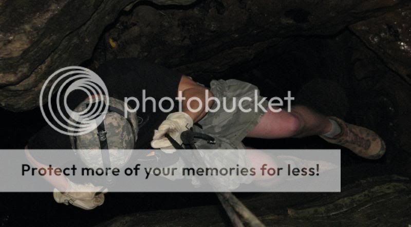
I have personally rappelled into the pit and found the
traditional cache Cavers Plunge (an extreme cache) GCRVXB. Its fun
to explore but can be very dangerous if precautions are not
taken.
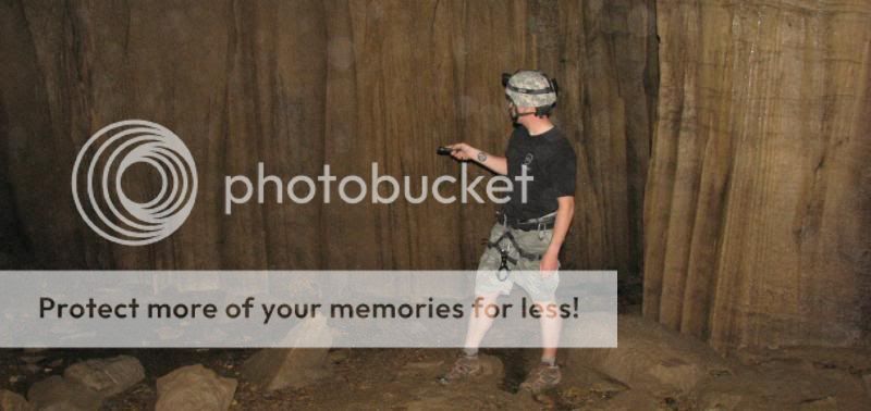
When at the site and before I did anything, I did a careful
check of the area and briefed the group I was with on what not to
do. I secured a safety line to myself by using a very sturdy tree
as an anchor line before approaching the pit.
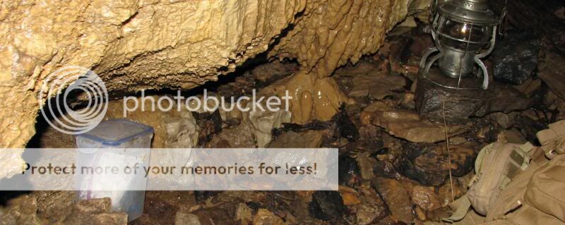
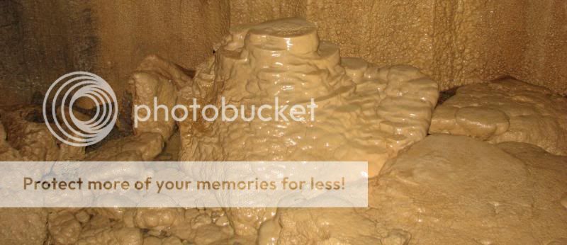
Once inside the pit cave, the ascent was incredible! At the
bottom I explored as much as I could and was careful not to damage
the artifacts on the pit cave floor. There are bones of numerous
animals that have fallen to their death here.
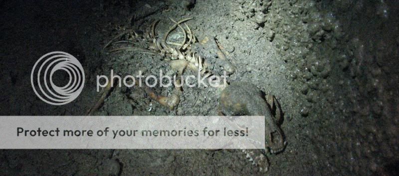
Wind Pit Cave is the venus fly trap for caves. Realize that Wind
Pit Cave has been here for thousands of years and what has fallen
into it's depths is collected on the pit cave floor.

Use good common sense when visiting. Do not be foolish and go
near the opening unless you are secured by a rope.
To get credit for this EC, post a photo of “you” ( a human face
of the cacher visiting the site) near the listed coordinates with
Wind Pit Cave in the background and please answer the following
questions.
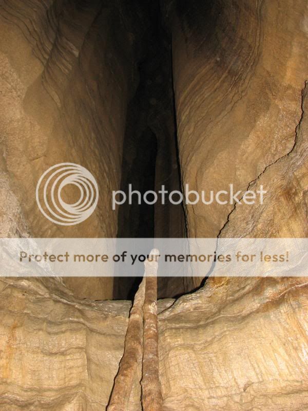
1. How wide and long is the opening of the pit?
2. Looking at the entrance, tell me what you think created
the opening.
This EarthCache
is rated a 5 star on terrain due to the hole being a dangerous trap
for those who get to close. Observe the hole from a safe distance
if you do not plan on rappelling in the pit.
Yep we know you are coming. Permission to enter the property
is allowed by the owner. Contact me if you want his name.
PLEASE NOTE:
Parking is limited. The provided parking coordinates is the best
place to park. The parking is located in front of Wind Cave. Access
to the EarthCache is by walking. You can not drive up to it. The
closest you can park to the EC before walking is about .20 (tenths)
of a mile.
The information
for this EarthCache is from the Kentucky Geological Survey and the
University of Kentucky Geology Department. Thanks to those who
enjoy EarthCaches and keeps Cav Scout placing
them.

| Cav Scout has earned GSA's highest
level |
 |
Do not log this
EC unless you have answered the questions and have a picture ready
to post! Logs with no photo of the actual cacher (human face
included) logging the find or failure to answer questions or
negative comments will result in a log deletion without notice.
Exceptions will be considered if you contact me first (I realize
sometimes we forget our cameras or the batteries die). You must
post a photo at the time of logging your find. If your picture is
not ready then wait until you have a photo.
Sources of
information for the EarthCache quoted from the librarian in the
Geology Department Library in Miller Hall, University of Kentucky.
I am by no means a geologist. I use books, internet, and ask
questions about geology just like 99.9 percent of the geocachers
who create these great Earth Caches. I enjoy Earth Caches and want
people to get out and see what I see every time I go and explore
this great place we live in.