Nestled in the suburbs of Chicago is a hidden treasure. Thousands of years ago, Native Americans lived along the West branch of the DuPage river. Three prehistoric Indian mounds remain and these are the only known mounds in DuPage County. These mounds were fully excavated and what remains is the mounds themselves. It is a beautiful area to visit. Please treat the area with respect. This land was formed by glacial movement and left behind moraines that supported the waters that sustained the people who lived here 1000 and 2000 years ago.

Winfield Mounds Map
Your Journey
You should park at the suggested parking waypoint. As you walk to the Winfield Mounds you will cross the DuPage River, see trees planted in a straight line (either as a part of a nursery in the past, or a part of reforestation in the 1970's), you will pass through Prairie land and a beautiful wooded area that used to be home to Native Americans. As you enter the woods after the walk through the prarie, you will see a large Oak tree to the west. This tree is an estimated 220 years old.
***As you walk past the large Oak tree, stop at these coordinates (N 41 52.805 W 88 09.579) and estimate the height of the moraine (river's surface to the path you are standing on) that was created by a glacial shift.
This walk will take approximately 40 minutes round trip or is a 20 minute bike ride. If you do bike, please walk your bike once off the Prairie Path.
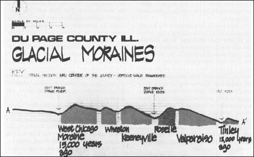
The Land - Glacial Moraines
Glacial Moraines are land formations that were created by the movement of a glacier. The moraines created in this area are key to sustaining life in the area of the Winfield Mounds.
The roots of both plants and people depend on soil. The earth’s deepest layer, over 4,000 feet deep is granite. The earth’s climate was tropical at one point in time, the land’s location closer to the globe’s equator and all continents were joined into one landmass called Pangea. When Pangea broke up 200 million years ago, North America drifted and tilted in a manner that exposed the northern part of Illinois above sea level and it became weathered down to it’s limestone base.
One million years ago, the DuPage vicinity looked much like the Galena area with high limestone hills and cliffs. During the Ice Age (Pleistocene Epoch), massive mountains of ice covered the region. Pressure from the weight of the mile-deep ice caused heat so intense that it melted the underside of glaciers and caused them to shift to the south. Land was leveled and flattened in it’s path and the glaciers brought along with them the erratic rocks that you will find in many earthcache locations. The last of the area’s glacier’s moved laterally as far as today’s West Chicago, it melted, brought along clay, sand and gravel and created the series of north-to-south ridges called moraines. The topography of DuPage is defined by the terminal moraines from west to east, now called West Chicago, Wheaton, Keeneyville, Roselle, Valparaiso, and Tinley.
Two other results of the glacial shift was the formation of the rivers. The West and East Branches of the DuPage River and Salt Creek followed the depressed areas between the moraines, where the meltwater was of such torrential force as to scour out the valleys. The gravel, the looser debris, was left strewn on the shoulders and floors of each valley. Such distribution accounts for the fact that 85 percent of the county's immediate subsurface consists mostly of clay, with scattered patches of silt and sand on upland moraines, while 15 percent consists of gravel along rivers and streams.
The glacial pressure cracked the limestone layer beneath the surface and created water-bearing layer called aquifers. The retreating ice sheet was followed by a dry period (hypsithermal) that lasted for several thousand years and provided the conditions necessary for prairie grass to spread and that distributed ground sand and silt containing nutrients that provided a richness of soil in this area. This rich soil created the base for fertile land for the animals and the Woodlands people who settled here. The prairie grass that you will pass on your way to the mounds is evidence of the aridity of the past.
By 4000 B.C., the climate became temperate, more like the conditions today. The DuPage vicinity became part of the “"Prairie Peninsula" in northern Illinois, for it is located on the edge of the prairie from the west and of the woodlands to the east, at the boundary of moisture streaming off the Gulf of Mexico and of the prevailing westerly winds. This intersection accounts for both the volatile weather and variety of plants. The hardwoods spread northward as moisture increased and would have displaced the prairie, but the introduction of people, newly arriving humans burned off the prairies to flush out game, leaving about 85% prairie and 15% oak and maple trees
The topsoil of DuPage is so rich because of the organic matter from prairie plants. Their roots go as deep as fifteen feet. This rich soil provided a plant life that was so critical for sustaining life in this area. One thousand years ago, the ridge of land that lay adjacent to the West Branch of the DuPage River was an ideal place to live. Food and water were readily available as were materials for building tools and household needs. The high grounds above the river provided good land for producing corn, beans and squash. There were animals available to hunt such as deer, elk, buffalo, ducks and geese. The river also allowed for trap and hook fishing of bass and sturgeon. There were raspberries, maple sap, rose hips and hickory nuts to gather.
As you can see, the glacial movement, creating moraines that created the West Branch of the DuPage river, along with the correct arid climate to create rich topsoil were key to sustaining life in this area.
To learn more about The People, The History of Mound Building and the Winfield Mounds, please visit this Letterbox:
Winfield Mounds Letterbox
Logging the Winfield Mounds Earthcache
1) Read the sign at the posted coordinates.
2) Then, at these coordinates (N 41 52.805 W 88 09.579) estimate the height of the moraine (river's surface to the path you are standing on) that was created by a glacial shift.
3) Observe and estimate the width of the river at this point.
4) What evidence exists here that proves that glaciers moved through this area?
Not requirements but you might want to...
1) Take look at the most prominent mound at N41 52.766 W88 09.645. If you walk 20-25 steps on the path to the south of the sign, you will come across a path to the east that will lead you to the mound.
2) It would be great (but is not required) if you would take a photo of yourself or your GPSr at the sign at posted coordinates.
Thanks
Two years ago, Abby and I went on a wonderful tour of the Winfield Mounds led by Jack MacRae of the Forest Preserve District of DuPage County. Thank you, Jack for your tour, for the article on the history of the Winfield Mounds and your permission to let me use the information in your article for this cache page.
Thanks to Amanda Hagen FPDDC for permission to have an earthcache at this site (permit number 285).
Thanks to GeoawareCA for publishing and TeacherMike for his assistance in the end.
Source: DuPage Roots by Richard A Thompson