 SK
SK
Po stránke prírodných krás je Liptov jednou z najkrajších oblastí Slovenska. Centrom Liptova je Liptovská kotlina, ktorá sa tiahne od Ružomberka po Štrbu v dlžke 50 km a maximálnej šírke 15 km.
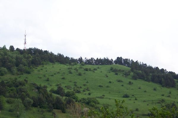
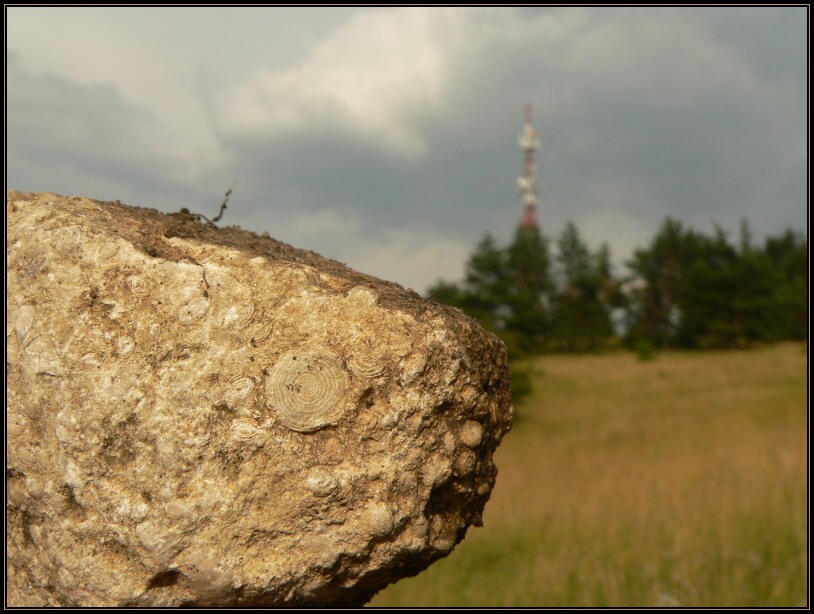
Obdobie tretohôr je pre vývoj Liptova a niektorých severných castí Slovenska osobité. Zaciatkom tretohôr sa tieto územia zacali naklánat na sever a ponárat pod more, ktoré tu vtedy existovalo. Územia dnešných Nízkych Tatier a Velkej Fatry mali už podobu horstva, aj ked ešte nie tak vysokého ako dnes. Vysoké Tatry boli len pahorkatinou, ktorú tretohorné more postupujúce zo severu postupne prelialo. Na dne Liptovskej kotliny, ktorá bola morskou panvou sa zacali usadzovat sedimenty. Typickým živocíchom pre tretohorné moria boli hlavne numulity. Je to vyhynutý jednobunkový živocích z rodu dierkavcov, ktoré si vytvárali schránky z uhlicitanu vápenatého a dosahovali velkost 1 mm až 15 cm. Významné nálezisko, kde sa dajú numulity na Liptove nájst, je pri Ružomberku na vrchole kopca Mních, v okolí veže vysielaca.
Vyskytujú sa tu najmä Nummulites perforatus sismondai, Nummulites millecnput, Numulites sariatus minor a Nummulites fabianii.
Na konci tretohôr bolo územie Liptovskej kotliny spod mora vynorené a odvtedy už bolo navždy súšou.
Trochu mysterie len pre Slovakov:
Povrava sa medzi ludmi z okolia, ze kedysi bol na tomto kopci klastor mnichov a templarskych rytierov. Odtial zrejme pochadza aj meno kopca "Mnich". A nielen to. Okolite kopce sa volaju Choc a Cebrat. Ich nazov vraj vznikol z vety:
Mnich chod zobrat...
Mnich-Choc-Cebrat
Seriozny archeologicky prieskum domnienky o klastore vyvratil. Ale predsa...tie brala na niektorych miestach tak velmi pripominaju ruiny a zaklady murov...
Podmienky zalogovania cache:
- priložit fotografiu z okolia vysielaca alebo nájdenej fosílie
- napísat odpoved na otázky: Ako vznikli skameneliny numulitov? Aké sú približne staré ich skameneliny?
 EN
EN
According to beauty of landscape, Liptov is the one of the most beautiful area in Slovakia. Centre of Liptov is Liptov basin stretched from Ružomberok to Štrba in length 50 kilometers and maximal width 15 kilometers.
Cenozoic period is individual for evolution of Liptov and other northern parts of Slovakia. Early in Cenozoic period these territories start lopsided to the North and immerge under sea, which existed here at that time.
Today’s land of the Low Tatras and Big Fatra were mountains but not so high as today. In the past the High Tatras were just heights, inundated by the sea northerly. At bottom of Liptov basin which were sea basin started to settle sediments. Typical sea animals for Cenozoic period were nummulites. It is extinct unicellular animal of the genus Foraminifera, which built their shells from calcite with size 1 millimeter to 15 centimeters.
Meaningful finding place where you can find a nummulites is near to Ružomberok on top of Mních hill by the transmitter. You can find here especially Nummulites perforatus sismondai, Nummulites millecnput, Numulites sariatus minor and Nummulites fabianii.
At the end of Cenozoic period was land of Liptov basin emerged from the sea and from that time is land forever.
To log cache you have to attached a photo of you with your GPS device or with fossil rock and answer educationnal questions:
- Describe the process of the creation of nummulite fossils
- What is the approximate age of fossil which can be found here?

 The most exciting way to learn about the Earth and its processes is to get into the outdoors and experience it first-hand. Visiting an Earthcache is a great outdoor activity the whole family can enjoy. An Earthcache is a special place that people can visit to learn about a unique geoscience feature or aspect of our Earth. Earthcaches include a set of educational notes and the details about where to find the location (latitude and longitude). Visitors to Earthcaches can see how our planet has been shaped by geological processes, how we manage the resources and how scientists gather evidence to learn about the Earth. To find out more click HERE.
