ILHA SABRINA

[S. Miguel – Azores]


EARTHCACHE 
PORTUGUÊS

A ILHA SABRINA
A luta entre o Mar e o Fogo.
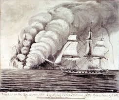
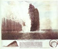
“No meio do oceano Atlântico, assim como em outros lugares da Terra, tem sido palco de uma luta insaciável entre o fogo e o mar, para dar origem a novos solos de cinzas e pedras que posteriormente serão devolvidos às profundezas que lhe deram origem. Ganhadores dessa lula, foram com certeza as nove ilhas e ilhéus açorianos, que depois de muita cinza e lava derrama, Era após Era, ergueram montanhas verdejantes sobre o majestoso oceano. Sorte menor teve a ilha Sabrina, que a sua conquista sobre as águas ferozes do mar durou apenas escassos meses. Tudo teve início em Janeiro de 1811, quando se deram os seus primeiros sinais de vida de uma nova ilha a surgir sobre as águas ao largo da ilha de S. Miguel, com bastante frequência até Junho borbulhavam gases emitidos pelo mar, acompanhados de abalos sísmicos, que deixaram a população assustada, derrubando casas, até que por fim, em Junho, dá-se uma violenta erupção submarina, que em poucos dias formou uma ilhota a aproximadamente 2 km da Ponta da Ferraria, na Ilha de S. Miguel. Dia após dia a ilhota foi crescendo, com sucessíveis explosões de escórias basálticas, cinzas e vapores, até atingir 90m de altura.
Por esta altura, um capitão de um navio inglês, James Tillard, pôde observar de perto, enquanto vigiava a costa de uma possível invasão francesa. Várias foram as tentativas de pisar aquele chão pouco consolidado, composto de escórias, ainda quentes, mas finalmente a 4 de Julho do mesmo ano, quando as erupções cessaram, pôde então, desembarcar na ilha, hasteando a bandeira britânica, tomando posse formal da ilha, batizando-a de Ilha Sabrina, nome do navio que comandava, HMS Sabrina. Daqui surgiu um grande conflito diplomático, entre Portugal e Inglaterra, que fico resolvido pelas forças da natureza: depois erupções cessarem, o mar começou a invadir a ilha, recentemente criada, erodindo toda a área, reduzindo-a uma pequena zona centrar por onde fumegava alguns gases. Oito meses depois o início da sua formação, em Outubro de 1811 já não restava qualquer vestígio de ilha ao largo da ilha de S. Miguel. Mas sabemos que a ilha Sabrina, dorme debaixo das águas do oceano, a a algumas dezenas de metros de profundidade, emitindo gases do interior da terra num cume situado a algumas centenas de metros de profundidade”.
Poderão ter ocorrido outras erupções submarinas nos Açores do tipo surtsiano após o povoamento, mas os Capelinhos, pela informação científica, e Sabrina, pelo incidente diplomático, tornaram-se nos dois casos mais famosos do Arquipélago deste estilo eruptivo!
TUFOS
Tufo:é designação comum dada a um vasto conjunto de rochas caracterizadas pela sua baixa densidade, reduzida consistência intergranular que se traduz na presença de grãos [ou partículas (clastos) de qualquer natureza]) facilmente desagregáveis.
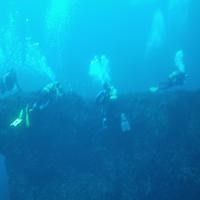
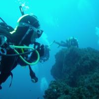
O MERGULHO
Esta earthcache tem um formato de uma multi-earthcache, com dois locais de mergulho (Way point 1 e GZ), que distam entre si cerca de uma milha náutica.
O mergulho avançado (nível 3 de experiência), tem de ser feito de escafandro.
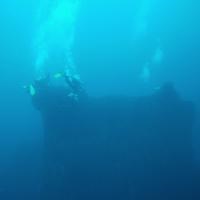
A zona do mergulho localiza-se em duas “baixas”, conhecidas no meio piscatório e junto dos entusiastas do mergulho com escafandro, como “Brilhante ou Sabrina” e “Lourenços”, situando-se a menos de duas milhas da costa, na zona da Ferraria.
São dois “cabeços”, relativamente próximos da superfície, que correspondem aos pontos de maior altitude, do que foi a ilha Sabrina.
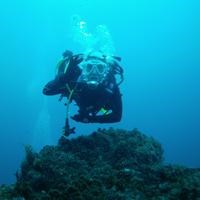
É uma zona onde é preciso ter muito cuidado, pois é um local que não fica “abrigado” pela ilha e que situa quase fora da “ponta da ilha”, sendo as correntes bastante fortes.
O mergulho neste local deve ser somente efetuado com mar calmo, pouco vento e de preferência com vento e corrente N/NE.
Recomendações:
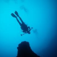
Convém sempre mergulhar acompanhado.
Tenha sempre em atenção, em primeiro lugar, a sua segurança!
PARA REALIZAR E REGISTAR ESTA EARTHCACHE:
Para realizar earthcaches “submarinas”, é necessário ir ao local, “ver bem” e estudar os fenómenos geológicos envolvidos…, aliás, como para qualquer outra earthcache… Devido às características destas caches, os owners recomendam que os “mergulhos” sejam bem planeados, com apoio de uma empresa certificada, tendo em atenção as condições meteorológicas (que, nos Açores, variam, por vezes, com grande rapidez) e que se mergulhe sempre acompanhado, como aliás “mandam as regras”.
PERGUNTAS:
Para “encontrar/registar” esta cache deverá: provar que esteve no local e responder às seguintes questões, enviando um email/mensagem de Geocaching, com as respostas, em português ou em inglês, para o nosso perfil.
Só depois, de enviar as respostas, e conforme as “guidelines” para as Earthcaches, deverá efetuar o seu registo!
Serão removidos todos os registos que não obedeçam a estes requisitos.
1. Estudando o tema geológico proposto nesta earthcache, responde às seguintes questões científicas e históricas:
a) Em que ano se deu a erupção que conduziu ao aparecimento da ilha Sabrina?
b) Caracteriza o tipo de vulcão que deu originou a ilha Sabrina? Diz se é conhecido, nos Açores, mais algum vulcão do mesmo tipo.
c) O fenómeno vulcânico que deu origem à Ilha Sabrina fica situado nas “fraldas” de um importante aparelho vulcânico. Qual?
d) Qual o fenómeno que levou ao desaparecimento desta ilha?
2. Observando o way point 1, “Baixa ou cabeço dos Lourenços”, responda às seguintes questões:
a) Descreve o cabeço lá existente, quanto à forma, comprimento, “tipo” de superfície e relevo.
b) A que profundidade média está este cabeço.
3. Observando o GZ desta earthcache, “cabeço Brilhante ou ilha Sabrina”. responda às seguintes questões:
a) Descreve o cabeço Brilhante, quanto à forma, comprimento, material que o compõe e “tipo” de superfície.
b) Caracteriza, do ponto de vista geológico, o “tipo” de material que compõe este cabeço.
4. TAREFA OBRIGATÓRIA:Deverá tirar uma foto sua, onde você apareça (ou com um papel/placa onde conste o seu nickname e a data da visita) e que comprove a sua presença no GZ desta EC - NÃO METASPOILERS. Esta foto deverá ser colocada no seu registo ou enviada por email ou sistema de mensagens de Geocaching, para o owner!
AGRADECIMENTOS:
Agradecemos a especial colaboração dos amigos mergulhadores João Gonçalves e Emanuel Cabral (Nélinho).

Não responderemos ao seu contato, a não ser que haja algum “problema” com as suas respostas ou registo.


SABRINA ISLAND
[S. Miguel - Azores]
ENGLISH

EARTHCACHE
SABRINA ISLAND
The struggle between the sea and the Fire.
"In the middle of the Atlantic Ocean, as well as in other places on Earth, has staged an insatiable struggle between the fire and the sea, to give new soil ash and rocks which will later be returned to the depths from which they originate. Winners of this fight, were certainly the nine Azorean islands and islets, which after much ash and lava pours, age after age, raised green mountains of the majestic ocean. Less fortunate was the island Sabrina, that his conquest of the fierce waters of the sea lasted only a few months. Everything started in January 1811, when it gave its first signs of life in a new island to emerge over the waters off the island of São Miguel, quite often until June bubbling gases emitted by the sea, accompanied by earthquakes who left the frightened population, knocking houses, until finally, in June, a violent underwater eruption happened, which in a few days formed a small island about 2 km from Ponta da Ferraria, on the island of São Miguel. Day after day the island was growing, with successor explosions of basaltic slag, ash and vapors to reach 90m in height.
By this time, the captain of an English ship, James Tillard, was able to observe closely, while guarding the coast of a possible French invasion. There were several attempts to step on that little consolidated ground, consisting of slag, still warm, but finally the July 4 of that year, when the eruptions ceased, could then land on the island, flying the British flag, taking formal possession of the island , baptizing them to Sabrina Island, ship name who commanded, HMS Sabrina. It came a major diplomatic conflict between Portugal and England, I get resolved by the forces of nature: after ceasing eruptions, the sea began to invade the island, newly created, eroding the whole area, reducing it to a small area where focus smoked some gases. Eight months after the beginning of its formation in October 1811 no longer remained any trace of island off the island of São Miguel. But we know that Sabrina Island, sleeps beneath the ocean waters, a few tens of meters deep, issuing land inside the gas a ridge situated a few hundred meters deep. "
there might have been other underwater eruptions in the Azores of surtsiano type after the settlement, but the Capelinhos by scientific information, and Sabrina, the diplomatic incident, have become the two most famous cases of the Archipelago of this eruptive style!
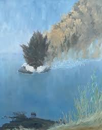
Sabrina Island: was formed by basaltic slag and despite having reached about 100 meters high, was quickly destroyed by sea erosion, so that in October 1811, there was only a shoal in the area where once had been the cone.
The area continues to release a large volume of gas visible to rise through the water column.
TUFO:
Tufo:it is common name given to a wide range of rocks characterized by their low density, reduced intergranular consistency that translates into the presence of grain [or particles (clasts) of any kind]) easily desagregáveis.
DIVING:
This EarthCache has a shape of a multi-EarthCache, with two dive sites (Way point 1 and GZ), that are distant from each other about one nautical mile.
The advanced diving (level 3 experience), must be made diving.
The diving area is located in two "lows", known in the fishing environment and among diving enthusiasts with diving as "Brilliante or Sabrina" and "Lourenços", standing less than two miles from the coast, in the area of Blacksmithing.
There are two "bollards", relatively close to the surface, which correspond to the points of higher elevation than was Sabrina island.
It is an area where you need to be very careful because it is a place that is not "sheltered" by the island and lies quite outside the "tip of the island", and the very strong currents.
Diving on this site should only be done with calm sea, little wind and preferably with wind and current N / NE.
Recommendations:
You should always dive together.
Always make sure,first comes your safety!
TO PERFORM AND LOG THIS EarthCache:
To perform "underwater" EarthCaches, you must go to the site, "see well" and study the geological phenomena involved ... Moreover, as for any other EarthCache ... Due to the characteristics of these caches, the owners recommend the "dips" are well planned with the support of a certified company, taking into account the weather conditions (which, in the Azores, vary, sometimes very quickly) and that immerse always accompanied, as indeed "send the rules."
QUESTIONS:
To "find / register" this cache must: prove that visited the site and answer the following questions by sending an email / message Geocaching, with answers (in Portuguese or in English, only) to our profile.
Only later, sending the answers, and as the "guidelines" for EarthCaches should make your registration! They will be removed from all records that do not meet these requirements.
1. Studying the geological theme proposed this EarthCache, answer the
following scientific and historical issues:
a) In what year was given the eruption that led to the birth of the
island Sabrina?
b) what features did the volcano that gave rise to the island Sabrina have?
Is some other volcano of the same type known in the Azores?
c) The volcanic phenomenon that gave birth to Sabrina Island is located
in the "baby" of a major volcanic apparatus. Which?
d) What is the phenomenon that led to the disappearance of this island?
2. Watching the way point 1, "Down the hill or Lourenços", answer the
following questions:
a) describe the existing hill there, in form, length, "type" surface and relief.
b) The average depth of this hill.
3. Watching the GZ this EarthCache, "hill Bright or Sabrina island"
answer the following questions:
a) Describe the Bright hill of shape, length, material that composes
and "type" of surface.
b) Features of geological point of view, the "type" of material that
makes up this hill.
4.
TASK (not optional): You must take a picture of yourself, where do you show up, (or with a paper / plaque with your geocaching nickname and the date of the visit) and that proves your presence in the GZ of this EC - no spoilers please. This photo must be placed in your log or sent by email or Geocaching messaging system, to the owner!

We do not respond to your touch, unless there is a "problem" with their answers or register.
AGRADECIMENTOS:
We appreciate the special collaboration of the divers friends João Gonçalves and Emanuel Cabral (Nelinho).