You will need a compass for answering the questions; binoculars may be helpful.
The Little Sugar River flows into the Sugar River about 5 miles to the east of this location. The Sugar River valley is mostly sand deposited as outwash from the glacier when it was at the Johnstown Moraine near Verona. As the Sugar River valley filled with sand, water in the Little Sugar River was dammed. Eventually, glacial meltwater stopped depositing sand in the Sugar River and the valley of the Little Sugar River filled with sediment until it was level with the Sugar River floodplain. This resulted in a stream with a very low gradient which caused the stream to meander (wind back and forth) more than most streams. Sediment continues to be added to a floodplain surface when the river floods.
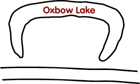
An oxbow is a U-shaped bend in a river or a separate body of water next to a meandering river. It is created over time as erosion and soil deposits change the course of a river.
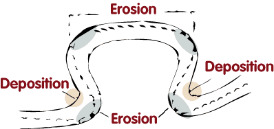
1) On the inside of the loop, the river travels more slowly leading to deposition of silt.
2) Meanwhile water on the outside edges tends to flow faster, which erodes the banks making the meander even wider.
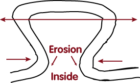
3) Over time the loop of the meander widens and the neck narrows. If a flood occurs at this stage, the neck may vanish altogether. Check the
USGS Water Resources website for a history of the water flow along the Sugar River floodplain near Broadhead.
4) Then the meander is removed from the river's current and the horseshoe shaped oxbow body of water is formed and the river becomes straighter at that point. The oxbow lake begins to fill with sediment. The sediment buildup will be silt during those times when the area is flooded. When it is not flooded, the sediment will primarily be organic matter. Eventurally the lake may be completely filled in. The formation of and filling in of oxbows can occur over a time period of a few years to several decades or longer, depending on the frequency of floods and presence of springs.
 IATCC is the cache designation to highlight a series of EarthCaches along the Ice Age National Scenic Trail grouped into a special category called "ColdCache."
The Ice Age Trail is one of eleven National Scenic Trails designated by the National Park Service. This unique trail is entirely within the state of Wisconsin and follows along the terminal moraine of the most recent glacier which retreated about 10,000 years ago.
This project is supported by the Ice Age Trail Alliance (IATA). The goal is to bring more visitors to the trail and promote public awareness, appreciation, and understanding of Wisconsin’s glacial landscape.
The IATA has created an awards program to encourage visits to the trail and ColdCache sites. This awards program is separate from, and in addition to, any other Geo- or EarthCache awards program.
A current list of approved ColdCache sites can be found on the “IATCC Bookmark List”. More information on the Ice Age Trail Atlas, the Companion Guide, the ColdCache Project and Awards Program can be found on the “ColdCache Webpage”
References:
Geology of the Ice Age National Scenic Trail; by David M. Mickelson, Louis J. Maher Jr., and Susan L. Simpson
Mussouri Botanical Garden (from MBGnet; http://www.mbgnet.net
The Geocache Notification Form has been submitted to Brad Bates of the Wisconsin DNR. Geocaches placed on Wisconsin Department of Natural Resource managed lands require permission by means of a notification form. Please print out a paper copy of the notification form, fill in all required information, then submit it to the land manager. The DNR Notification form and land manager information can be obtained at:
www.wi-geocaching.com/hiding
- When you approach the oxbow from the west (River Road), what are the coordinates where the oxbow is first visible? And when is it first visible from the east (Silver Road)?
- AS you view the oxbow from various locations, is the open or closed side of the oxbow closest to the trail? Based on this information and looking closely at the diagrams; where is the river in relation to the trail?
- Assuming that only floods of greater than 8,000 cubic feet per second cover the floodplain of the Sugar River near Broadhead; a) how many times has this happened since records were maintained (beginning in 1914)?; b) when was the last flood of greater than 8,000 cubic feet per second?; c) what effect would this flood history have on the oxbow