Located near the summit of Slieve Muck in the Mourne Mountains,
at a height of 2200 feet, there are several possible approaches.
The simplest is to park at N54 09.662 W6 03.305. Across the
road a stile will bring you to a wall which you can follow to the
summit. The parking spot is already at a height of some 1200 feet
leaving just 1000 feet to climb.
Alternatively this cache could be combined with several others,
Do an ascent,
Lough Shannagh aspect,
Lake of the Foxes and
Spelga to give a circular route.
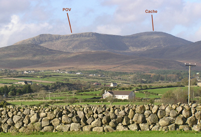
To appreciate where the cache name comes from you need to
approach from the southeast. Muck is a long mountain stretching
south from its summit, with a gentle slope to the west which
provides the many streams making it the source of the river Bann.
To the east is a sheer drop. Viewed from some distance, and in the
right light, this vertical section appears to have the letters POV
carved into it. Local imagination easily extends this to be the
Poverty Mountain.
When I first climbed this mountain I assumed that it got the
name, Muck, from the extremely wet conditions when approached from
the east, following the Mourne Wall. I have since learned that
Slieve Muck means 'mountain of the pig'.
Not buggy friendly.
The cache is a small tab-lock box wrapped in a black cover sheet.
Please dress appropriately for a mountain walk where the weather
can change suddenly.
