
 As
you embark or continue your journey to discover and explore
beautiful and historic rocks, waterfalls, peaks, creeks and other
wonders, please keep in mind that these places need to remain wild
and protected so that they may be enjoyed by others for generations
to come. Please be diligent in respecting these sites by doing the
following:
As
you embark or continue your journey to discover and explore
beautiful and historic rocks, waterfalls, peaks, creeks and other
wonders, please keep in mind that these places need to remain wild
and protected so that they may be enjoyed by others for generations
to come. Please be diligent in respecting these sites by doing the
following:
- Please keep trash with you at all times, do not leave it behind
in these pristine places.
- Bury human waste 6 inches deep, make certain you are at least
50 paces away from any water source and PLEASE bring your toilet
paper and sanitary items back out with you.
- Keep food and all scented items on your person at all
times.
- Support wildlife by allowing them to find their own food, do
not feed them.
- Allow plants to grow and water to stay clean by staying on
trails, bike paths and roads.
Thank you, Yosemite Wilderness Management
The hike to examine the joints of the Sierra Batholith is
classified as a strenuous one. There is a significant elevation
gain and many steps. The last restrooms and water are at Vernal
Fall.
The coordinates for this EarthCache only take you to the final
climb to Nevada Fall. Nevada Fall is the first of three sharp
descents from Little Yosemite Valley to Yosemite Valley that are
called the Giant’s Staircase. These three descents are only
part of a series of glacial steps that start at the base of Mount
Lyell and extends 21 miles to Yosemite Valley. In that distance
there is a 7,600 foot elevation drop.
The Sierra Nevada Mountains are composed of the more than 100
individual plutons that are collectively called the Sierra
Batholith. The batholith solidified deep underground
between the Late Jurassic to Early Cretaceous (between 184 to 132
million years ago). As the rock above the pluton was eroded and the
Sierra Nevada were uplifted, joints formed in the rock.
Joints are natural cracks that form in rock. There is usually
little if any movement along a joint, which is what distinguishes a
joint from a fault. Joints form from changes in pressure or
stresses, placed on the rocks. These stresses include stretching,
compression, and relaxation.
Relaxation joints form from the removal of stress. Rock deep
underground has the weight of all the rock above it pressing down
on it. As erosion removes the rock from above, the weight of the
rock is reduced. This reduction in the weight on the rock allows it
to expand, similar to the way a squished sponge would expand after
the weight is taken off of it. However, rocks are much more brittle
than a sponge, so they fracture creating joints. Because joints are
locations where the rock has already broken, joints are areas of
weakness.
Millions of years later, during the Wisonsonian Glaciation that occurred between
70,000 and 10,000 years ago (divided into the Tahoe, Tenaya, and
Tioga glaciations in the Sierra Nevada) glaciers eroded the various
features found throughout Yosemite.
The Merced Glacier filled Little Yosemite Valley and flowed down
into Yosemite Valley along the path of the Merced River. Before
glaciation, the valley had an initial slope as shown by the dotted
line (AA) in the figure below (Mathes1930). As the glacier flowed
over the joints in the granite, those areas were eroded at a faster
rate than the areas with fewer joints
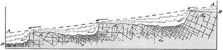
(Matthes 1930)
Logging questions:
- The text "GC2M27Q Yosemite Giant's Staircase" on the first
line.
- The number of people in your group.
- Compare the amount of jointing in the valley walls (be sure to
look up the sides) to the amount of jointing at the top of Nevada
Fall?
- When heading back down, take the approximate coordinates of
where the jointing that allowed Vernal Fall to form.
The following sources were used to generate this
cache:
- Matthes, Francois. 1930 USGS. Geological Survey
Professional Paper 160 Geologic History of the Yosemite Valley.
http://www.nps.gov/history/history/online_books/geology/publications/pp/160/index.htm
Last Updated: 28-Nov-2006
- Kiver, Eugene and David Harris. 1999. Geology
of U.S. Parklands Fifth Edition, John Wiley & Sons,
Inc.