

The third annual Delaware Challenge
is back: First State Challenge 2011 sponsored by Delaware
Geocachers! Now its moved to a fall event.
There are about 20 new caches
spread across the state of Delaware by volunteer cachers to give
you an appreciation for the great areas of the First State. These
should all be fairly easy to find as they are either small or
regular size with a maximum rating of 2/2.
To complete this challenge and be eligible for a small Challenge
tag & certificate at the challenge event, you must complete the
following:
1. You must find and log ALL FSC-2011 caches- both at the cache
location and online.
2. Record the code phrase written in the log book of each hide and
email your completed list of all FSC-2011 code phrases to
FSC2011@aol.com
3.For your convenience, there is a form on the Delaware Geocaching
Website at First State
Challenge 2011 - Form although the use of this form is not
required.
4. There will be a Challenge Event (12/10 in Dover) open to all
cachers. At this event, those that have been verified as completing
the challenge, will be eligible for a small Challenge tag and
Completion certificate.
5. The small Challenge tags are limited to the
first 100 cachers who complete the challenge.
6. More information can be found on the Delaware Geocachers
FSC-2001 Page First State
Challenge 2011 or on the forum page
First State Challenge 2011 Forum
Description: Picture from Pomeroy and Beers 1868 Atlas of
Delaware
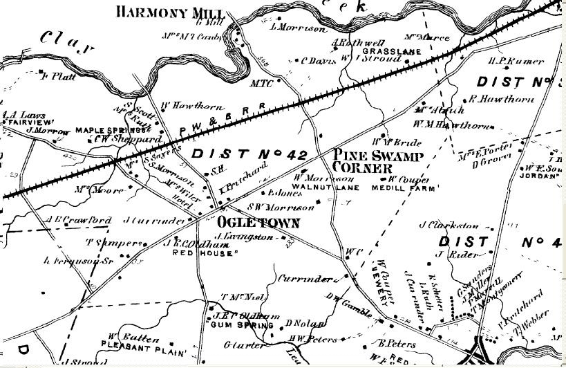
Ogletown, Delaware was a small hamlet that grew up around the
intersection of the "Great Road from Christiana Bridge to Head of
Elk", now Rts 4 and 273, where Thomas Ogle had built a house and
tavern around 1739. Maps from the 1800's show an inn and six or
seven houses around the intersection and by 1868, a school.
The history of the area goes back much further than the 1800s.
Archeological surveys show a number of prehistoric sites in the
area. Several of the prehistoric sites were "Procurement Sites",
but along Paradise Lane and at The Dairy Queen site were larger
archeological finds that may have been "Base Camps". Datable
artifacts found at these sites include items which date back to the
Archaic (6500 to 3000BCE) and Woodland I (3000 BCE to BC 1000)
periods, making this a very important historic area.