 Der Weissestein
(Text in Englisch und Deutsch / text in english and german)
Deutsch /
German:
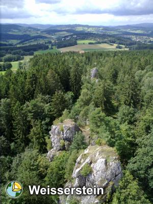
Auf diesem geologisch interessantem Felsaufwurf tront eine
Burgruine, Burg Weissenstein. Ein interessanter Lehrpfad führt
durch den Wald rund um die Quarzformation. Er bietet geologische
und geschichtliche Informationen der hiesigen Region und gehört zum
Naturpark Bayerischer Wald.
"Teufelsmauer, Hexenwerk - die volkstümlichen Bezeichnungen für den
Pfahl (von lat. pallidus = bleich, fahl) lassen erkennen, daß die
bizarren weißen Felsen schon früh die Phantasie der Menschen
beschäftigten.Fast schnurgerade verläuft der Pfahl auf einer Länge
von über 150 km von Fürholz bei Freyung im Unteren Bayerischen Wald
bis nach Schwarzenfeld in der
Oberpfalz.
Der milchig-weiße Pfahlquarz besteht zu 95-98% aus Kieselsäure (SiO
). Gelbliche bis schwach rötliche und graue Farbvarianten werden
durch geringe Anteile von Eisenverbindungen und Verunreinigungen
durch Pfahlschiefer verursacht.
Wegen seiner relativ hohen Verunreinigung wurde der Pfahlquarz von
den Glashütten nur ausnahmsweise für die Glasherstellung benutzt.
Eine wesentlich bedeutendere Rolle spielte er als Schotterlieferant
für den Straßenbau im Bayerischen Wald. Heute ist der Pfahlquarz zu
einem gesuchten Rohstoff der chemischen Industrie geworden. Zum
Beispiel wird aus Quarz gewonnenes Reinst-Silizium für die
Mikrochip- und Solarzellenherstellung verwendet." (von Tafel 2 des
Burglehrpfad Weissenstein")
"Der Pfahl ist mit über 100 km Länge eine der bedeutendsten
tektonischen Strukturen in Bayern. Die hydrothermale Quarzfüllung
der Bruchstruktur bildet häufig Härtlinge. Die ca. 30 m hohen
Zinnen des Weissensteins wurden durch pleistozäne Erosion
freigestellt und bilden eine der markantesten Formen im
Pfahlverlauf."
(Dr.Glaser
in:
(
visit Link))
Um den Cache loggen zu dürfen müsst ihr folgendes
machen:
1) Korrekte
Antworten auf folgenden Fragen finden und an uns schicken
(
GC-Email).
a) Wie ist diese geologische Formation
entstanden?
b) Welche Gesteinsart fasst
den
Quarz-Pfahl
ein?
c) Wieviele Zinnen und Fenster kann man vom Standort
der
Infotafel am Burgturm
sehen?
2) Sofort (ohne auf unsere Bestätigung zu
warten) Loggen ein Foto mit euch und dem Weissenstein
hochladen.
Sollten Eure Antworten nicht korrekt sein, melden wir uns!
Sollte nach unserer Email keine korrekte Antwort kommen (so in 3-4
Tagen) löschen wir den Log!
Englisch / English:
On top of
this geologically interesting accumulation of rocks, we find the
ruin of the castle "Weisserstein". An interesting educational trail
leads through the forest around this formation of quartz. It offers
geological and historical information of the region and belongs to
the natural reserve "Bavarian Forest".
The traditional terms "Devil's Wall" or "Witches' Deed" indicate
that these white and bizarre rocks have been of great interest in
early history already. On a distance of about 150 km, the pale of
quartz leads straight up from Fürholz near Freying in the "Lower
Bavarian Forest" to Schwarzenfeld in the Oberpfalz.
The milk white pale is composted of 95-98% silicic acid (SiO).
Yellow to faint red and grey colours are induced by bound
fractions of iron and the pollution by the pale slate.
Because of its high grate pollution, the pale quartz was used only
exceptional for glass production. It had an essential
importance
as
gravel
for
roadworks in the bavarian region. Today the pale is a demanded
material by the chemical industry, to produce cleanest silicia for
microchips or solar cells for
example.
With
its length of more than 100km, the quartz pale is one of the
most
important
tectonic structures in Bavaria. The hydrothermic content of
quartz in
the break structure often forms hardened rocks.
The about
30m measuring battlements of the "Weissenstein" were
isolated
by
pleistocenic erosion and shape one of the most prominent forms in
the
course of
the quartz pale.
To log the cache you will have to proceed als follows:
1) find
correct answers to the following questions and send them to
us (
GC-Email)
.
a) How have this geological formation come into
existence?
b) The quartz pale is surrounded by which kind of
rock?
c) How many battlements and windows on the castle tower
are to be seen from the position of the info
panel?
2) log and
upload a photo of yourself and the
Weisserstein