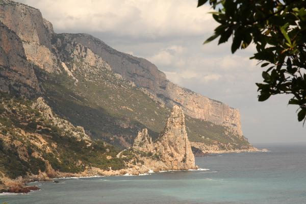
The "Perda Longa" is a pyramidal
monolith which rises perfectly vertical from the sea level. It
dates back to the mesozioic age. It is placed in the first part of
the coastline between Santa Maria Navarrese and Capo di
Monte Santo which is characterized by a high cliff which
exceeds 280 meters in height.
The ancient sailors choose "Perda Longa" as a
datum-point because it determines the south end of the Supramonte
region which they called "Guglia", "Aguglia" or Agugliastra" (which
meens small tower) because of its peculiar shape.
"Agugliastra" seems to be the origin of
today's name of this region: Ogliastra.
From this point one has a fantastic view
along the hole cliff of the eastern cost of this Region of
Sardegna.
To get to the coordinates you can go there by
car, or you may take a 2 hours hike from "Santa Maria Navarrese"
throught" a fantastic nature.
And don't forget to stop looking at your GPS
and enjoy the country side!
To log this cache you have to do send us the
following information in an email (please don't write them in the
log entry):
1. Of what kind of rock is the "Perda
Longa" build?
2. How high is the monolith?
3. Send a picture of you and your GPS with
the "Perda Longa" in the background.
Have fun!