
 There is no need to reach the exact coordinates. Somewhere along the Queen Kaahumanu Highway near the coordinates the climate changes from one dominated by the rain shadow to one free of the rain shadow. You will be locating the coordinates where you think the change occurs (+ or – a half mile or so).
A rain shadow is the dry area on the leward side of a mountain or mountain range. A rain shadow is formed when tall mountains force wet moist air up. As the air moves up, it expands due to the decreased pressure and cools. This phenomenon is called Orographic Cooling (See Hawaiian Orographic Cooling).
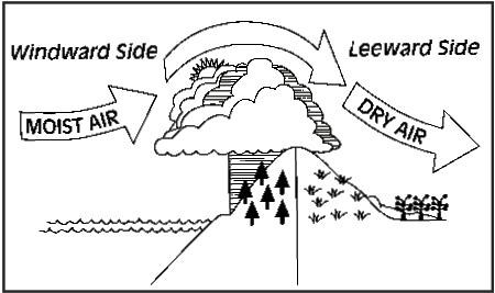
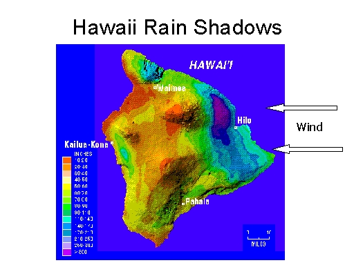
Mauna Kea and Mauna Loa force the warm moist trade winds from the west up and over their 12,000+ height. As the air masses gain altitude, they cool forming clouds and rain on the eastern slopes of Hawaii. The area just west of Hilo receives almost 300 inches of rain per year (the purple area in the figure). Then on the western side, the air descends and warms providing little rainfall. Some of the areas on the western side of the island receive only about 9 inches of rain per year (the red areas).
The rain shadow has a profound affect on the erosional rates and biota of the area. Obviously the areas that receive a lot of rain have lush green plants, while the areas with little rain look much like desert. You will also see steep and deep canyons with regularly flowing rivers (See Pololu Valley) on the wet side. The dry side will have ephemeral streams and valleys that are more likely eroded by infrequent flooding.
Many of the rain shadows around the world are formed by long and wide mountain ranges. Thus to see both the wet and dry sides usually requires quite a bit of driving and the changes are very gradual. However, the Hawaiian volcanoes create a very sharp contrast over a very short distance while driving along Queen Kaahumanu Highway.
Rain shadows are used by geologists in reconstructing paleoenvironments and paleogeography. As geologists get clues about the presence of ancient mountain ranges and latitudes they can predict which of the surrounding areas received more or less rainfall. Or the reverse, if they find a sediments from a dry environment they may postulate that a mountain range existed in a certain direction that blocked rain fall. Geologists may also expect different types of erosion on either side of these mountain ranges, constant water flow and a lot of biotic activity on the wet side, and infrequent high-flow events on the dry side.
For the logging requirements post your answers in the log:
- The text GC5D7EE Hawaiian Rain Shadow Along Queen Kaahumanu Highway on the first line
- The number of people in you group.
- Send me the coordinates of where you think is the transition from the dry to wet side of the rain shadow (this will be +- about 0.5 mile).
- What features did you use to determine the transition?
- Is there a mountain feature that coincides with the transition?
The above information was compiled from the following sources:
- http://www.trishock.com/academic/mountain.shtml
- http://www.theweatherprediction.com/habyhints/33/
- http://www.theweatherprediction.com/habyhints2/502/


Find more Earthcaches