VOLCÁN OSORNO - LOS LAGOS
English Version:
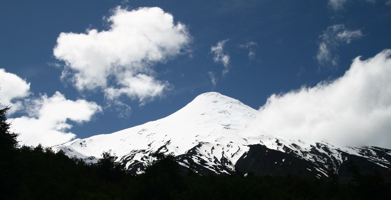
Volcán Osorno is a 2,652 m (8,701 feet) tall conical
stratovolcano lying between the provinces of Osorno and Llanquihue,
in Los Lagos Region of Chile. It stands on the southeastern shore
of Lake Llanquihue, and also towers over Todos los Santos Lake.
Osorno is known worldwide as a symbol of the local landscape, and
is noted for its similar appearance to Mount Fuji.
Osorno is one of the most active volcanoes of the southern
Chilean Andes, with 11 historical eruptions recorded between 1575
and 1869. The basalt and andesite lava flows generated during these
eruptions reached both Llanquihue and Todos los Santos Lakes. The
upper slopes of the volcano are almost entirely covered in glaciers
despite its very modest altitude and latitude, sustained by the
substantial snowfall in the very moist maritime climate of the
region.
This stratovolcano, also called a composite volcano, is a tall,
conical volcano composed of many layers (strata) of hardened lava,
tephra, and volcanic ash. Such volcanoes are characterized by a
steep profile and periodic, explosive eruptions. The lava that
flows from them is viscous; it cools and hardens before spreading
far. The magma forming this lava is classified as felsic, having
high to intermediate levels of silica (as in rhyolite, dacite, or
andesite), unlike less viscous mafic magma, which forms shield
volcanoes (such as Mauna Loa in Hawaii), having wider bases and
more gently sloping profiles. Although stratovolcanoes are
sometimes called composite volcanoes, volcanologists prefer
stratovolcano because many other volcanoes have a composite
(layered) structure — they are built up from sequential
outpourings of eruptive materials. Stratovolcanoes are one of the
most common types of volcanoes.

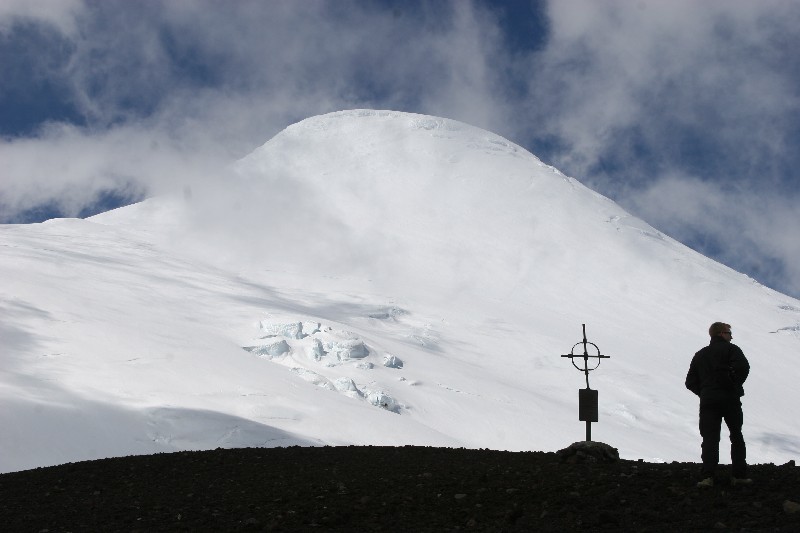
To log this Earthcache answers the following questions by
mail:
1. Estimates: How many parasitic cone can you see from the
coordinates and into which direction?
2. Exactly at the coordinates is a cruz. Which date is on
that.
3. Upload a photo with you and your GPS in the hand in front of the
volcan.
All other logs will be deleted.

Deutsche Version:
Volcán Osorno ist ein 2,652 m hoher kegelförmiger Stratovulkan
und liegt zwischen den Provinzen Osorno und Llanquihue in der Los
Lagos Region von Chile. Er liegt am südöstlichen Ufer des Lago
Llanquihue und ragt auch über den Lago Todos los Santos empor.
Osorno ist weltweit als Symbol der Chilenischen Kraterlandschaften
bekannt und wird wegen seiner Ähnlichkeit auch Fuji genannt.
Osorno ist einer der aktivsten Vulkane der südlichen
Chilenischen Anden, mit 11 aufgezeichneten, historischen Ausbrüchen
zwischen 1575 und 1869. Die während dieser Ausbrüche erzeugten
Basalt- und Andesite-Lava-Flüsse erreichten sowohl den Lago
Llanquihue, als auch den Lago Todos los Santos. Die oberen Abhänge
des Vulkans sind fast gänzlich von Gletschern bedeckt, trotz seiner
sehr bescheidenen Höhe und Breite. Das liegt am hohen
Schneefallaufkommen in diesem sehr feuchten Seeklima der
Region.
Dieser Stratovulkan, auch Schichtvulkan genannt, ist ein großer,
kegelförmiger Vulkan, der aus vielen Schichten gehärteter Lava,
Lockermasse Tephra, und vulkanischer Asche besteht. Solche Vulkane
werden durch ein steiles Profil und periodische, explosive
Ausbrüche charakterisiert. Ursache für ihre Entstehung ist vor
allem der Kieselsäure-Gehalt des Magmas. Dadurch ist das Magma
relativ zähflüssig – fließt also nicht sehr weit und bildet
dicke Lavaströme. Es handelt sich dabei meist um differenziertes
Magma, also Magma, das sich aus basaltischem Magma entwickelt hat
oder um Magma, das durch Einschmelzung des unteren Teils der
Erdkruste entsteht. Es ist relativ kalt. Der hohe Gasanteil
bewirkt, dass die Eruptionen explosiv verlaufen und zwar meist im
Wechsel zwischen austretendem Lockermaterial, genannt Tephra
(Bomben, Lapilli, Aschen), und Lava.
Um diesen Earthcache loggen zu dürfen, beantworte folgende
Fragen per mail:
1. Schätze: Wie viele Nebencrater siehst du von den Koordinaten aus
und in welche Richtung?
2. Genau an den Koordinaten befindet sich ein Kreuz. Welches Datum
steht darauf?
3. Lade ein Foto zum Log hoch, mit dir und deinem GPS in der Hand
und dem Vulkan im Hintergrund.
Alle anderen Logs werden gelöscht.