The Tara River Canyon EarthCache
-
Difficulty:
-

-
Terrain:
-

Size:  (not chosen)
Please note Use of geocaching.com services is subject to the terms and conditions
in our disclaimer.
The Tara River Canyon (Montenegrin: Kanjon Tare),
also known as the Tara River Gorge, is the longest canyon in
Montenegro and Europe and the second-longest in the world. It is xx
kilometers long and is x.xxx meters at its
deepest.
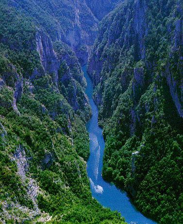
"The jewel of Europe", violent, clear and wild Tara is a huge water
mass made from snow and rain. The Tara River CanyonIt belongs to
the National park ‘Durmitor". It rises from the mountain range in
the northern part of the country and it flows 140km. It meets the
Piva river and together they make the Drina river, one of the
longest and water-richest rivers in the Balkans. For centuries,
with its strength the Tara river has been hollowing out a soft
limestone surface giving it a sculptural form full of gorges, large
rocks or chasms. Century-old earth erosion has created xx km long
canyon, the second largest canyon in the world after the Grand
Canyo of the Colorado. At some places, it is up to x.xxx m deep.
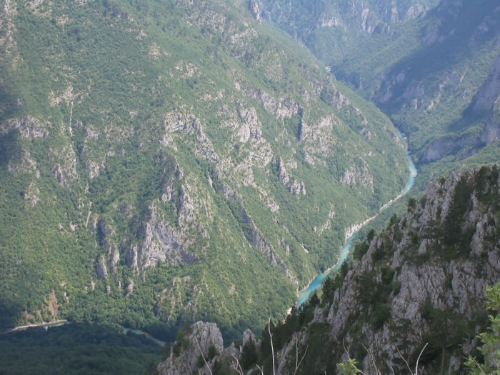
Its banks are steep, covered with a forest rising from the canyon’s
cold and depth. River TaraOnly at some places does the furious Tara
give the impression of being a calm river. The rare places that
might be crossed are called fords. Near Bistrica, the Tara riverbed
is so narrow that local people used to jump across it when
necessary. This unusual place is called Djavolje lazi (Devil’s
lanes). Around the river, the vegetation is very dense: black pine,
eastern hornbeam, black ash, elm, linden, and in higher areas,
above the rocks, one can see cork oaks, hornbeams, maples, beeches.
In the areas over than 1000m, fir and spruce forests can be found.
The black pine forests are of a special value. "Crna poda (Black
poda)" is the most valuable black pine forest with unusually high
trees. Some trees are almost 50m high and 400 years old.
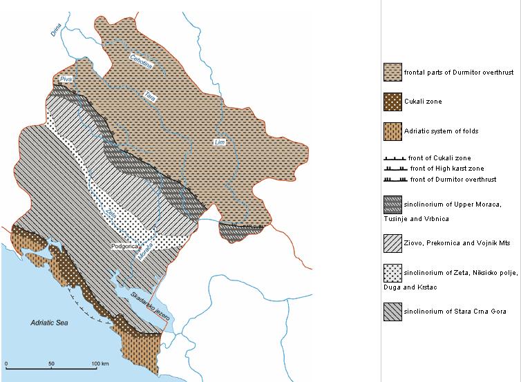
Over two-thirds of the territory of Montenegro belongs to the
karst of south-eastern Dinarides. The karst in Montenegro differs
along the territory, by its distribution and position, its position
in relation to the non-karstic terrain and the Adriatic sea, and by
its occurrences (various forms and dimensions) and processes. This
comes as a consequence of diverse sedimentation conditions, as well
as different geologic evolution of individual parts of the Dinaric
geosyncline (both in space and time). A segment of the Dinaric
geosyncline which forms the terrain of Montenegro, is predominantly
(on two thirds of the territory) built up of limestone and dolomite
sediments (from Devonian; to the nowadays). Since the end of
Devonian period (ending phase of Caledonian orogeny), it has been
uplifted and lowered by numerous phases of Hercynian and Alpine
orogeny. Due to epeirogenic and orogenic movements in different
geological times, since the end of the Devonian period to the final
uplifting of Dinaric geosyncline, when present territory of
Montenegro (end of Middle Miocene) has been formed, some parts of
the geosyncline bottom have been, more or less, uplifted and
lowered. This caused favourable conditions for sedimentation of
different products, among which were dominant those who have formed
limestones and dolomites of great thickness and distribution. It is
easily noticeable that the epeirogenic and orogenic movements have
been advancing from north-east to south-west. During those
movements, there were relatively quiet periods when small islands
existed, protruding above the sea level as islands. The climate was
also variable, but mostly favorable for the development of
karstification. Simultaneously with these movements, particularly
during the Laramidian orogeny (Upper Cretaceous - Lower Paleogene),
the folding, faulting, overthrusting and even movements which
caused creating of nappes occurred. As a result, the rock porosity
increased favouring the karstification process and forming today's
karst - a geological product of very complex and enigmatic
occurrences and processes.
If you want to log this cache, you have to
complete three tasks.
Send me (through my profile):
1) How long is the canyon created by the
erosion (in km) ?
2) What is the deepest place of the canyon (in meters)?
3) Take a picture of you on the river (or on the brigde) and upload
the image accompanied with the photoplace coordinated to your
log.
Additional Hints
(No hints available.)